Openstreetmap-carto: Strange rendering of amenity=toilets as a brown circle at zoom level 19
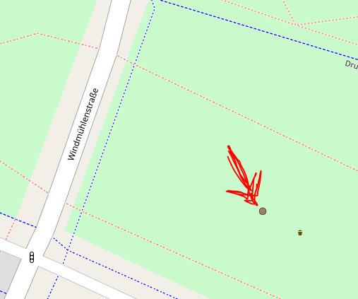
Since the last update (v4.7.0), amenity=toilets are rendered as a brown circle instead of the toilets symbol at zoom level 19 (but not at zoom levels 17–18):

I suspect this to be a bug, because I couldn't fine a reference in the change log (and this change doesn't seem to make sense).
 ghost
ghost
All 18 comments
Could you post a link to this location? Otherwise it'd be hard to investigate it.
 kocio-pl
on 29 Jan 2018
kocio-pl
on 29 Jan 2018
The screenshot was from here:
but it seems to affect all amenity=toilets.
ghost
on 29 Jan 2018
I don't see this effect wnywhere. Could you post which rendering server are you being served by?: http://tile.openstreetmap.org/cgi-bin/debug
Mine is orm.openstreetmap.org .
kocio-pl
on 29 Jan 2018
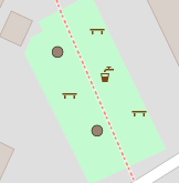
Same with playgrounds:
https://www.openstreetmap.org/#map=19/49.99088/8.27042
Unfortunately I have just redrawn the plaground, so probably you won't see it any more.
 geowas-github
on 29 Jan 2018
geowas-github
on 29 Jan 2018
Please also report which server did such rendering, I suspect this the source of the problem.
kocio-pl
on 29 Jan 2018
How do I see this?
geowas-github
on 29 Jan 2018
Through the link I included:
kocio-pl
on 29 Jan 2018
orm.openstreetmap.org
geowas-github
on 29 Jan 2018
I have seen this just for a moment with orm, but now it's gone. I will check it again tomorrow.
kocio-pl
on 29 Jan 2018
I don't see this effect wnywhere. Could you post which rendering server are you being served by?: http://tile.openstreetmap.org/cgi-bin/debug
scorch.openstreetmap.org
There are even leisure=pitch + sport=table_tennis nodes rendered as brown circle:
ghost
on 30 Jan 2018
Same thing with the access=permissive + barrier=gate.
Link to node history
 alexander-ii
on 30 Jan 2018
alexander-ii
on 30 Jan 2018
For the record, bicycle_parking at z=19 is also concerned but surprisingly, not all are modified (related to the cache?). At z=18, the correct icon appears.
Example : https://www.openstreetmap.org/node/4693394595
z=18

z=19
 jragusa
on 30 Jan 2018
jragusa
on 30 Jan 2018
Looks like a real style bug, I guess v4.7.1 would be needed soon...
So the first thing is to find the faulty commit.
kocio-pl
on 30 Jan 2018
Might it be related to the entrances query?
        (SELECT
            way,
            tags->'entrance' AS entrance,
            access
          FROM planet_osm_point
          WHERE tags->'indoor' = 'no'
            OR tags->'indoor' IS NULL)
         AS entrances
Seems very general to me, and this block in entrances seems to only filter on the access tag:
#entrances {
  ...
 [zoom >= 19] {
    ...
    ["access" = "yes"],
    ["access" = "permissive"] {
      marker-fill: @entrance-permissive;
    }
    ["access" = "no"] {
      marker-fill: @entrance-normal;
      marker-file: url('symbols/rectdiag.svg');
    }
  }
  ...
}
 zerebubuth
on 30 Jan 2018
zerebubuth
on 30 Jan 2018
This was my primary suspect, thanks for taking a look at it!
In case this is a real reason, the question is if it can be fixed soon ( @tpikonen ?) or it should be just reverted?
kocio-pl
on 30 Jan 2018
I confirm that the access tag is responsible of the bug because bicycle_parking without this tag are correctly rendered.
jragusa
on 30 Jan 2018
Yes, the bug is where @zerebubuth indicated. I'll prepare a PR soon.
 tpikonen
on 31 Jan 2018
tpikonen
on 31 Jan 2018
Ok, please test PR #3048 if you can. Entrances and toilets with permissive access now render correctly here, but it would be nice to get a confirmation.
tpikonen
on 31 Jan 2018
Related issues
 polarbearing
·
5Comments
polarbearing
·
5Comments
 dktue
·
4Comments
dktue
·
4Comments
 Tomasz-W
·
4Comments
Tomasz-W
·
4Comments
 HolgerJeromin
·
3Comments
HolgerJeromin
·
3Comments
 meased
·
3Comments
meased
·
3Comments
Most helpful comment
I confirm that the
accesstag is responsible of the bug becausebicycle_parkingwithout this tag are correctly rendered.