Openstreetmap-carto: Render highway=service thinner
As it is a lot of people are not adding the type of service road because rendering of the specific tags is to thin. So it would be good if parking aisles and driveways were just rendered the same width as regular service roads. Or if that doesn't work maybe at least a little thicker then they are currently rendered.
 Adamant36
All 41 comments
I am not surprised by that. Is it a single person or something on a larger scale?
 matkoniecz
on 25 Aug 2019
matkoniecz
on 25 Aug 2019
It's on a large scale. At least here in America. Especially in shopping centers.
It seems like people will either tag parking aisles as such but not be specific when tagging the driveways or they just strip the parking aisle/driveway tags if they are there so both render wider. Every time I've messaged someone who removed the tags they have said it's because they are rendered to thinly. Although I normally wouldn't advocate for rendering to be changed based on the wishes of people who are removing good tags to make things look better, I do feel like the rendering is a little thin as it currently is.
Here's some examples of driveways not being specifically tagged but parking aisles having it. Maybe I haven't 100% zeroed in on the specifics of the problem or the solution yet. Maybe driveways should just be rendered thicker then parking aisles or something. That would likely increase more specific tagging of those things, but wouldn't solve removal of the tags on parking aisles though.
https://www.openstreetmap.org/#map=18/38.44178/-122.74906
https://www.openstreetmap.org/#map=19/38.81277/-77.18536
https://www.openstreetmap.org/#map=18/38.81069/-94.49292
https://www.openstreetmap.org/#map=17/40.03053/-75.62325
https://www.openstreetmap.org/#map=18/34.18267/-86.85056 (here the driveways are tagged as minor roads)
Adamant36
on 26 Aug 2019
I think there's a lot of confusion around the parking aisle and driveway tags.
The service=parking_aisle wiki page says:
The main way(s) on the parking lot, for entering and connecting multiple parking_aisle, should be mapped with highway=service, only.
Personally I follow this, which sometimes means stripping the tag where someone has applied it to an entire car park. As for driveways, I don't see any obvious driveways in the areas you have linked. The service=driveway wiki page says:
Generally speaking, in or around a parking lot (amenity=parking) – use highway=service without service=* on the entrance and exit ways, as well as any way that forms the "trunk" or perimeter of the lot, connecting multiple parking aisles (service=parking_aisle)
I must admit the very thin rendering looks pretty bad when one of these ways meets the endpoint or corner of a thicker way. I think it looks good when they are perpendicular though.
 kymckay
on 26 Aug 2019
kymckay
on 26 Aug 2019
I don't see the advantage your suggestion would bring. service=* tagging on highway=service is very common (10M of 26M features) so it is important to consider this in rendering. More than two classes for service roads however are hardly feasible in rendering. Hence the differentiation in major and minor. And driveways are often the most minor of all minor service roads.
 imagico
on 26 Aug 2019
imagico
on 26 Aug 2019
I also agree that it's helpful to render minor service roads thinner, especially driveways and parking aisles, which are not very important on a general map. I find it surprising that some mappers are mistagging features because of this rendering, since it seems like a clear improvement to have thinner private driveways.
 jeisenbe
on 26 Aug 2019
jeisenbe
on 26 Aug 2019
Please note that service=driveway is frequently associated with access=private (25 %) which also decreases their readability.
 jragusa
on 26 Aug 2019
jragusa
on 26 Aug 2019
I think it's more confusing that we have two widths for highway=service to begin with, one for highway=service without service= and one for highway=service with service=. In my experience this has led people to tag narrow roads with highway=service instead of using a width= tag, just because highway=service is rendered narrower than highway=residential.
If we were to increase the width of highway=service with service=, cities where people have mapped the individual driveways to people's residences will look super funny, if not downright obtrusive.
 Prince-Kassad
on 26 Aug 2019
Prince-Kassad
on 26 Aug 2019
The main way(s) on the parking lot, for entering and connecting multiple parking_aisle, should be mapped with highway=service, only.
If that's the case then I don't think the wiki should say driveways are used for tagging the main service roads leading to a business property. It's never tagged that way and if it was you'd have weird rendering/tagging like service=driveway -> highway=service -> service=parking_aisle or thin -> thick -> thin rendering. Which makes no sense.
To my knowledge the main ways on the parking lots in America have always been called driveways anyway or else where does the driveway end and the service road begin? Like on the driveway wiki it says they "may end at or pass the entrance." Which sounds exactly how a service road is being described in the quote above. The road that passes the stores entrance is the main way.
Adamant36
on 1 Sep 2019
My 2¢:
I'd agree that parking aisles should render the same width as highway=service, perhaps with a slightly different fill color or casing. These tend to have two lanes or about 6 m in width and usually don't end in a dead end.
But driveways are often intended to be the "last mile" in the road network, have 1 lane or are about 3 m wide and end at am entrance of a house, garage or dock. I'd keep them as today's or a render them _slightly_ wider (~1/2 residential's width).
(If you have mapped a driveway that leads to another way, probably it shouldn't have been mapped as a driveway, methinks.)
 IgorEliezer
on 1 Sep 2019
IgorEliezer
on 1 Sep 2019
Many parking aisles are only 1 lane wide, and only 3 or 4 meter wide,
e.g. in Asian cities where spaces is at a premium. These are the ways
that directly access each parking space, not the main way entering the
parking lot. Since they are also terminal parts of the routing
network, I think it's reasonable that they are rendered as minor
service ways, like private driveways.
jeisenbe
on 1 Sep 2019
My thing is that if driveways are higher on the road importance hierarchy then highway=service or service=parking_aisle like it sounds on the wiki then they should render thicker both of them. Otherwise, the wiki needs to changed to reflect the fact highway=service is the most important and the differences between both of them need to be made clear. I don't care which one is changed though. As long as one of them is. Since it's obvious from the mass amount of miss/random tagging and unclear definitions that there is a problem with the current situation. Whether it be rendering or the definitions of the tags.
Adamant36
on 1 Sep 2019
I am trying to check if I am understanding situation correctly - not sure whatever it reached point of tagging discussion that should happen elsewhere or it it something that should still happen here.
if driveways are higher on the road importance hierarchy then highway=service
driveways are not higher on the road importance hierarchy than highway=service without service tags
I don't think the wiki should say driveways are used for tagging the main service roads leading to a business property
I am pretty sure that there is difference (both in importance and mapping) between
- road leading to large parking complex like at https://www.openstreetmap.org/?mlat=50.08894&mlon=19.89951#map=18/50.08894/19.89951 (tagged highway=service)
- road leading to individual business property (that may have small parking) like at https://www.openstreetmap.org/?mlat=50.05898&mlon=19.92347#map=19/50.05898/19.92347 (tagged highway=service service=driveway)
https://www.openstreetmap.org/#map=19/38.81277/-77.18536
https://www.openstreetmap.org/#map=18/38.81069/-94.49292
https://www.openstreetmap.org/#map=19/38.81275/-77.18489
What is wrong with mapping here? Seems correct to me as far as service roads go. I see problems just one or two roads - looks like typical first pass mapping to me, not indicator systematic mistagging.
I would consider it as indicator of mapper who adds data without checking what exactly was mapped rather than indicator of systematic mistagging.
https://www.openstreetmap.org/way/601345828#map=19/34.18294/-86.84973
Here problem is opposite than reported - service=parking_aisle was used where it should be just highway=service
https://www.openstreetmap.org/#map=18/38.44178/-122.74906
And this one is simply highly incomplete.
Since it's obvious from the mass amount of miss/random tagging
In case of mass amount of wrong mapping - can you link cases where there was recently mapped area where mapper systematically refused to use (or removed) service=driveway or service=parking_aisle? Not just where mapper should be more careful and missed tag on very small part of ways?
https://osmus.slack.com/archives/C029HV951/p1567324710077100 - I asked on US slack for more feedback because for me it seems to not be reporting a real issue but I may be simply biased because it is well suited to situation in my region
matkoniecz
on 1 Sep 2019
On Sun, Sep 1, 2019 at 3:51 AM Mateusz Konieczny notifications@github.com
wrote:
I am trying to check if I am understanding situation correctly - not sure
whatever it reached point of tagging discussion that should happen
elsewhere or it it something that should still happen here.if driveways are higher on the road importance hierarchy then
highway=servicedriveways are not higher on the road importance hierarchy than
highway=service without service tagsI don't think the wiki should say driveways are used for tagging the main
service roads leading to a business propertyI am pretty sure that there is difference (both in importance and mapping)
between
- road leading to large parking complex like at
https://www.openstreetmap.org/?mlat=50.08894&mlon=19.89951#map=18/50.08894/19.89951
(tagged highway=service)- road leading to individual business property (that may have small
parking) like at
https://www.openstreetmap.org/?mlat=50.05898&mlon=19.92347#map=19/50.05898/19.92347
(tagged highway=service service=driveway)One source of confusion is that the editors urge mappers, when mapping
highway=service, to select a value forservice=*.
The way I see highway=service used around here, the hierarchy tends to
run:
Most significant: The absence of service=*, which tends to be used for
farm roads that serve multiple properties but otherwise go nowhere (most
often these are privately maintained with the landowners sharing the
costs), roads on large industrial facilities and other private campuses,
and similar 'leaves' in the highway network. The final tier of 'this is a
road' where 'residential' and 'unclassified' are not appropriate.
Intermediate significance: 'service=driveway' - used around here for the
entrances and exits of business properties, the main way that connects a
bunch of parking fields, etc; and service=alley.
Lowest service=drive_through (often located in a parking lot, and usually
accepting just a regular car), and service=parking_aisle.
Mappers tend to choose one or the other of these, (most often driveway)
simply because, when offered the choice, they pick one. I'm not aware of
anywhere else in the data model where the absence of a tag denotes a way of
greater significance. If we had things like service=agricultural or
service=industrial to handle the (often access=private or
access=destination) ways that are common in some places, we might have less
confusion.
In colloquial use in the US, it's not too uncommon to hear the large
service ways called 'driveways' - "Smith Drive is the shared driveway for
four farms in Berne Township" (And said driveway is big enough to allow two
large farming vehicles to pass abreast - so it would be at least
'unclassified' if it actually went anywhere and weren't
'access=destination').
>
>
https://www.openstreetmap.org/#map=19/38.81277/-77.18536
https://www.openstreetmap.org/#map=18/38.81069/-94.49292
https://www.openstreetmap.org/#map=19/38.81275/-77.18489What is wrong with mapping here? Seems correct to me as far as service
roads go. I see just one or two roads - looks like typical first pass
mapping to me, not indicator systematic mistagging.https://www.openstreetmap.org/way/601345828#map=19/34.18294/-86.84973
Here problem is opposite than reported - service=parking_aisle was used
where it should be just highway=servicehttps://www.openstreetmap.org/#map=18/38.44178/-122.74906
And this one is simply highly incomplete.
Since it's obvious from the mass amount of miss/random tagging
In case of mass amount of wrong mapping - can you link cases where there
was recently mapped area where mapper systematically refused to use (or
removed) service=driveway or service=parking_aisle?—
You are receiving this because you are subscribed to this thread.
Reply to this email directly, view it on GitHub
https://github.com/gravitystorm/openstreetmap-carto/issues/3850?email_source=notifications&email_token=AABU6UPHPBU37L43PDAAUL3QHNX7JA5CNFSM4IPKC532YY3PNVWWK3TUL52HS4DFVREXG43VMVBW63LNMVXHJKTDN5WW2ZLOORPWSZGOD5T4YLA#issuecomment-526896172,
or mute the thread
https://github.com/notifications/unsubscribe-auth/AABU6UJRZHVPDH53VI2T2QTQHNX7JANCNFSM4IPKC53Q
.
--
73 de ke9tv/2, Kevin
 kennykb
on 1 Sep 2019
kennykb
on 1 Sep 2019
One source of confusion is that the editors urge mappers, when mapping
highway=service, to select a value forservice=*.
A while ago I proposed on the tagging list to introduce a generic service=* value for the 'major' service roads, to avoid that emptiness.
 polarbearing
on 1 Sep 2019
polarbearing
on 1 Sep 2019
service=parking_aisle are frequently closely spaced in parking, if you increase their width you may clutter the parking, especially if amenity=parking_space are also mapped
jragusa
on 1 Sep 2019
driveways are not higher on the road importance hierarchy than highway=service without service tags
Most of the problems I'm seeing have to do with business parks/shopping centers. The way I've always seen highway=service used is as a generic service way catch all when people don't what specific service=* tag to use or when when they just don't feel like adding the extra details (like how shop=yes or other similar "generics" are currently being tagged). A lot it I think comes from @kennykb's points. There really should be a generic service=* tag to avoid the emptiness as @polarbearing suggests. Also though, people are consciously choosing to remove the service=* tags when they are there because highway=service renders thicker then service=*. Which are rendered to thinly IMHO and also in the opinions of many of the people I've messaged about it who have removed the tags. So, I do think the current rendering is a problem and should be changed if it's also a tagging issue or not.
That said, if you go by the wiki and look at driveways as the service roads that lead to a business and highway=service as the roads that connect to parking aisles it does sound like driveways are higher on the road property there. As they would have more lanes, inflow/outflow traffic, connect to major roads (when service roads don't) etc. Like the wiki says driveways "typically branche from a bigger road." Which sounds more important to me then service roads that are "used for access to parking" or as @kennykb says above about them "farm roads that serve multiple properties but otherwise go nowhere" and "roads on large industrial facilities and other private campuses." Both definitions I agree with and they also both seem to align with the wiki. Like a service road going between buildings on a college campus but not connecting to the larger road network in any meaningful way at all isn't more important then a driveway a large shopping center that connects to a major secondary road.
Btw @jragusa, now that there's been some discussion about this, it seems to be more about the rendering of highway=service compared to service=driveway (at least for me) then parking aisles. I agree making parking aisles thicker might clutter things up to much. I don't think that would be the case with driveways though and there should be a way to tell them apart from parking aisles when they are mapped in business or industrial parks besides removing the service=driveway tags. If my point above about priority is correct driveways should be rendered thicker then both parking aisles and highway=service also. I'll probably update the title of the issue after a few more comments to reflect it.
Adamant36
on 1 Sep 2019
To my knowledge the main ways on the parking lots in America have always been called driveways anyway or else where does the driveway end and the service road begin?
American English calls all sorts of access roads “driveways”, and I often see this usage reflected in misuse of the service=driveway tag.
Like on the driveway wiki it says they "may end at or pass the entrance." Which sounds exactly how a service road is being described in the quote above. The road that passes the stores entrance is the main way.
I’m the one to blame for that passage on the wiki, which is based on a previous wording. But please consider the passage in the context of the full page. I wanted to emphasize that driveways generally dead-end, but I didn’t want someone to untag a short service=driveway just because it happens to loop back around to the main road or a parking lot. Here’s the image that the wiki page gives as an example of a driveway that passes the entrance (under the porte-cochère) and rejoins another roadway:

I think it’s entirely appropriate for larger parking lots, such as around this mall, to have ways not tagged with service=* or with service set to something else like collector that doesn’t already have other meanings.
Distinguishing higher-traffic service roads from lower-traffic parking aisles and driveways enables renderers to reduce visual clutter at lower zoom levels. It also enables routers to reduce _aural_ clutter. Many drivers find it insults their intelligence when a navigation application tells them to turn right then left then right on unnamed aisles in a parking lot, so these applications can suppress instructions for parking aisles and driveways but retain them for other service roads.
Meanwhile, making driveways wider or more prominent would have an adverse visual impact on residential areas where a driveway leads up to each house.
 1ec5
on 2 Sep 2019
1ec5
on 2 Sep 2019
I also agree that rendering parking aisles/driveways thinner is beneficial and reduces clutter because there are so many of them in cities. Service roads without service=* usually span longer distances, thus are important to be emphasized on the map.
I don't understand why mappers would reduce parking aisle tagging just because "they are rendered too thin". The width of the road rendering was never intended to somehow match the real width of the road. While that would be nice, that would be based on the 'width' tag, not just the road class. As was pointed out, in some countries aisles are 6 m wide, in others they are just 3m wide.
Looks like the mappers are mapping for the renderer (which one?) and didn't really understand the OSM semantical tagging.
 aceman444
on 2 Sep 2019
aceman444
on 2 Sep 2019
I also agree that rendering parking aisles/driveways thinner is beneficial
Then it should be beneficial to render highway=service thinner also since they are mapped in exactly the same situations as service=driveway is in cities. Where they are exactly the same distance. Rendering isn't based on distance anyway though. For instance compare how long some track roads are but also how thin their rendering is. There's zero correlation there. I took parking aisles out of it though just to appease people with your opinion. Driveways versus normal highway=service is the main issue anyway. As I said already above.
Looks like the mappers are mapping for the renderer (which one?) and didn't really understand the OSM semantical tagging.
Like I also said above, there should be a visual way to tell driveways apart from parking aisles (the actual physical things that exist on the ground next to each other) in business areas without the only option being stripping the service=driveways tags to do so as is currently going on. As much as it might be tagging for the render, which I'm 100% against, it's for a specific valid (in my opinion) reason in this case. Which is why I opened this issue. It's either a problem with definition between service=driveway versus highway=service (as I outlined above and know one has a good answer for) or with rendering (which is my guess because I've discussed it with the people who are doing the tag stripping). Either way, it needs to be dealt with. Personally, I'd prefer on the rendering side. Maybe driveways could use slightly different color then parking aisles. I don't really care. Although I've heard repeated complaints about the width. So that's I'm saying needs to be changed. It doesn't mean other options couldn't be explored though. Just don't shot the messenger in the meantime ;)
Adamant36
on 2 Sep 2019
As thinner service roads take up less space and look better, I always thought that Carto is doing another influence here - motivating mappers to put service road classification.
This is because relying on _service_ tag to be not filled to get some classification is in my opinion wrong - because when _service_ tag is missing, it is not clear if service classification is missing, or it was checked and identified as _service=[null]_.
 tomass
on 2 Sep 2019
tomass
on 2 Sep 2019
@matkoniecz, any updates from the slack channel about this by any chance? I tried to create an account, but I guess it wouldn't let me.
Adamant36
on 6 Sep 2019
https://wiki.openstreetmap.org/wiki/List_of_OSM_centric_Slack_workspaces has an invitation link (overcomplicated registration is probably needed to limit spam)
matkoniecz
on 7 Sep 2019
Reviewing the discussion above, it appears that there is consensus that driveways and parking aisles ought to be de-emphasized in the rendering, and the current thinner style is effective for this. There is currently some discussion on the tagging list about when to use service=driveway or not, but based on the current tagging system our rendering matches the most common practice. Therefore, I am closing this issue as declined.
jeisenbe
on 8 Nov 2019
Reviewing the discussion above, it appears that there is consensus that driveways and parking aisles ought to be de-emphasized in the rendering, and the current thinner style is effective for this.
That doesn't address the rendering of highway=service though. Which was the main point of the issue. What about rendering them thinner since they don't seem to be more important in the road network then the other two? Also, the mailing list discussion only deals with the use of the driveway tag in residential areas, which wasn't my issue, and it hardly discusses how they compare to highway=service. Plus, it just went off topic to paid mapping. So, I'd appreciate it if you re-opened the issue until it's actually figured out. Since I don't think it is.
Adamant36
on 9 Nov 2019
What about rendering [
highway=servicewithoutservice=*tag] thinner?
Are you requesting
1) Removing the difference between the two types of service roads and highway=service ways without service=* tags be rendered the same as highway=service + service=driveway?
2) Adding a 3rd category of rendering, to render highway=service ways without service=* tags be rendered wider than highway=service + service=driveway but narrower than those with some other set of service=* tags
3) Rendering highway=service ways slightly thinner, which would make them less similar in width to residential/unclassified but more similar to minor-service features like service=driveway, service=parking_aisle?
I don't think any of these 3 options would work well. Option 1) was rejected by several contributors who commented above.
Currently this is the width used for the 8 types of roads with white or light gray fill
class | width (pixel) z16 | z17 | z18 | z19 | z20 | ground width z20 @ 0° in m
-------|-------|-------|-------|-------|--------|--------------------
tertiary | 10 | 18 | 21 | 27 | 27 | 4.05m
tertiary link | 7 | 12 | 13 | 16 | 16 | 2.4m
residential+* | 6 | 12 | 13 | 17 | 17 | 2.55m
road | 3.5 | 7 | 8.5 | 11 | 11 | 1.65m
service | 3.5 | 7 | 8.5 | 11 | 12 | 1.8m
minor-service | 2 | 3.5 | 4.75 | 5.5 | 8.5 | 1.275m
(*residential is the same as living street and pedestrian)
There is no room for a clearly-distinct 3rd width of service road between service and minor-service at z16 or z17, because only a few pixels of width separate the two types there.
Similarly, making service narrower would make it too similar to minor-service at these zoom levels.
At z20, the current service z12 pixel wide rendering is only 1.8 meters wide at the equator, so it is already narrower than most roads that are passable by motor vehicles.
So options 2) and 3) are probably not feasible, based on this analysis.
jeisenbe
on 9 Nov 2019
Similarly, making service narrower would make it too similar to minor-service at these zoom levels.
Well, from some quotes above
I must admit the very thin rendering looks pretty bad when one of these ways meets the endpoint or corner of a thicker way.
Which I agree with and would be fixed by making them the same width.
There's also
I think it's more confusing that we have two widths for highway=service to begin with, one for highway=service without service= and one for highway=service with service=.
Again, the answer here would be making them the same width.
Along with
I'd agree that parking aisles should render the same width as highway=service, perhaps with a slightly different fill color or casing.
Again, the answer is making them the same width.
As thinner service roads take up less space and look better, I always thought that Carto is doing another influence here - motivating mappers to put service road classification.
Again, the answer here would be making them the same width.
And finally (semi-related)
Please note that service=driveway is frequently associated with access=private (25 %) which also decreases their readability.
The answer here would be making them slightly bigger.
So, going by the comments it seems like
This is actually a problem
They should be rendered as the same width
The width should be slightly wider then service=driveway currently is (per the last comment)
rendering them in a slightly different color then each other is a possible way to tell them apart instead of width that wouldn't have it's problems (my guess is that it would also help with the miss-tagging, or tag stripping, that is currently going on).
Adamant36
on 9 Nov 2019
I consider the differentiation between major and minor service roads as beneficial. Adding a different colour increases confusion and wastes a colour value. Different width works fine for me.
polarbearing
on 9 Nov 2019
Adding a different colour increases confusion
I know it's slightly different, but in iD Editor driveways are colored light brown and it doesn't cause any confusion. It's obvious what kind of service road something is from context. The different distinctions in rendering don't actually add anything to the map except inconstancy IMHO. Anyway, it's easy to say that about something that hasn't been tested. But go ahead and opt for the status quo. Doing so doesn't resolve the issues about the current rendering that me and others have brought up though. Maybe if your going to shot down the solutions we propose you could at least suggest your own. You know "offer suggestions as to how things may be improved" and all that.
Adamant36
on 9 Nov 2019
Mind that highway=service, along with access=no + psv=yes, is used for bus or trolleybus tracks. They are currently rendered thinner than the residential ways.
 Local: https://www.openstreetmap.org/#map=19/-23.66806/-46.53250
IgorEliezer
on 9 Nov 2019
in iD Editor driveways are colored light brown
As you recognise yourself, iD is an editor, not cartography. In JOSM I have several settings to colour-code roads depending on my editing goals. I can colour-code addresses matching street names, or maxspeed, or visualise turn:lanes. These are editing tools, not cartography.
As it is a lot of people are not adding the type of service road because rendering of the specific tags is to thin
This is your top post argument, do you have any evidence that people are doing that, and how many? You cannot count me in, as I _do_ add 'parking_aisle' to parking aisles _because_ they render thinner than the access road into the lot. And because the tagging is considered correct, of course.
Maybe if your going to shot down the solutions we propose you could at least suggest your own.
In my foreign speaker's grammar book, 'going to' requires the infinitive, so I am not familiar with your subtle differences in meaning when using the past. I am not shooting anything. I just see no problem with the current width distinction, thus I am not obliged to propose anything different. I propose to keep it as it is.
polarbearing
on 9 Nov 2019
I consider the differentiation between major and minor service roads as beneficial.
@polarbearing, read @tomass' comments, https://github.com/gravitystorm/openstreetmap-carto/issues/3798#issuecomment-552167837 and https://github.com/gravitystorm/openstreetmap-carto/issues/3940#issuecomment-544351803, and tell me what you think. I agree with the idea that there can't be "major" and "minor" service roads when highway=service is not actually it's own road type, but a default, catch all, for when someone doesn't define the type of service road. Therefore, rendering as if it's a "major" road, compared to driveways or parking aisles, is wrong.
IMHO It's not a true individual road type that is distinct from the service=* values or let alone a "major" road type compared to them. Which is why people have repeatedly used it as a tag in cases where "this service road looks wider then the others, and highway=service renders the widest. So, I'll just go with that." Even in cases where service=* tags were already used. I've seen it done repeatedly and had plenty of conversations about it.
My experiences aside though, there's more then enough comments here that there is issues with how highway=service is currently rendered. Along with, IMHO, enough comments that it is ill defined and miss-used as a tag in general, including in the recent tagging mailing list discussion about it, to warrant rethinking how it's currently rendered. I was under the impression that the style doesn't generally render ill defined, miss-used tags. Let alone render them in a way that leads to the tag being favored over other, more accurate ones.
Btw, OsmAnd renders them exactly the same. It's not confusing and looks better then the style IMHO.

Compared to
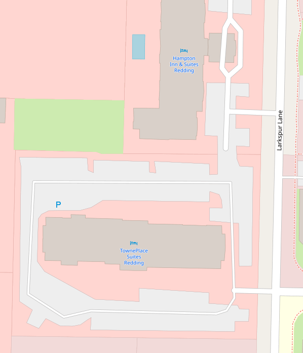
Also, that spot here is a good example of exactly what I'm talking about. Both parking lots are mapped by the same user and are totally inconsistent with how highway=service should be used. For instance the little nub "driveway" going into TownePlace Suites Redding is tagged as highway=service when it shouldn't be. Notice the wiki says highway=service is "commonly used for access to parking, driveways, and alleys." Yet I frequently see it miss-tagged the way it is there and at the other hotel. Other examples are easy to find. People just don't seem to use the driveway tag in commercial or retail areas at all.
Adamant36
on 10 Nov 2019
People just don't seem to use the driveway tag in commercial or retail areas at all.
It's because those are not driveways, as per service=driveway on the wiki:
Generally speaking, in or around a parking lot (amenity=parking) – use highway=service without service=* on the entrance and exit ways, as well as any way that forms the "trunk" or perimeter of the lot, connecting multiple parking aisles (service=parking_aisle)
However, I agree that the service=* tag is highly misused - for example the way tagged as a parking aisle in your screenshot is not a parking aisle. I actually like the thinner rendering because it makes such mis-tagging obvious.
kymckay
on 10 Nov 2019
It's because those are not driveways
So, there's no such thing as driveway in a commercial or retail area then? What about the examples given in the last two photos of the service=driveway article? It seems like the first one with the over hang in front of the building and the white car on the left would be comparable to the service road in front of Hampton Inn and Suites Redding in my example. Also the wiki page says "It typically branches from a bigger road and leads toward an entrance to a specific destination (building, etc.). It may end at or pass the entrance." Which in this case would be the entrance to the Hampton Inn and Suites Redding building would it not? That's exactly the situation the second to last image on the wiki shows. It's not "in or around a parking lot."
Adamant36
on 10 Nov 2019
Compared to
I would argue the confusion here stems from the use of service=parking_aisle being incorrect as shown, since it also acts as a "trunk" road for the property (for lack of a better term). The wiki pages for service=parking_aisle and service=driveway have extensive guides regarding correct and incorrect usage of the tag that are worth reading through carefully.
 btwhite92
on 10 Nov 2019
btwhite92
on 10 Nov 2019
I agree with the idea that there can't be "major" and "minor" service roads when highway=service is not actually it's own road type, but a default, catch all, for when someone doesn't define the type of service road.
Ideally that would be the case, but then we’re missing a suitable tag for the perimeter/“trunk” roads around a parking lot. I’m not surprised, because we tend to have tags for things that English has words for.
What about the examples given in the last two photos of the service=driveway article? It seems like the first one with the over hang in front of the building and the white car on the left would be comparable to the service road in front of Hampton Inn and Suites Redding in my example.
Yes, the little spur that goes under the porte-cochère should be tagged service=driveway according to the examples. But I don’t think people are avoiding that tagging practice because of this renderer’s treatment of driveways. If anything, the thinner treatment would be an incentive to tag a driveway in this case.
Rather, I think the impediment (at least in English-speaking countries) is that the tags don’t match colloquial English usage 100%. If I were to take 10 native American English speakers to this Hampton Inn and asked them what they’d call that spur, a few might say “driveway”, a few more might hesitate and still come up with “driveway” because of my impatient glare, and a few more would say they have no word for it.
I don’t know about you all, but I didn’t learn the terms “parking aisle” and “porte-cochère” until I started micromapping parking lots. If the problem is that service=driveway is underused, then the solution is to improve documentation and make it more discoverable to mappers, not to erase the distinction that tag produces in rendered output.
1ec5
on 10 Nov 2019
@btwhite92 ,
I would argue the confusion here stems from the use of service=parking_aisle being incorrect as shown, since it also acts as a "trunk" road for the property (for lack of a better term).
According to the wiki "A parking aisle is a service road that passes between one or two rows of parking spaces providing direct access for a motorized vehicle to enter and leave a parking space." Which is what roads do. They aren't roads "commonly used for access to parking." They are roads through the parking. Everyone will see it differently though. That's the problem.
The wiki pages for service=parking_aisle and service=driveway have extensive guides regarding correct and incorrect usage of the tag that are worth reading through carefully.
I directly quoted the article for service=driveway in my last response, but OK. The problem must be that I'm reading it wrong or not "carefully" enough. Right 🤷♂ Also, calling the service=driveway article "extensive" is laughable at best.
Ideally that would be the case, but then we’re missing a suitable tag for the perimeter/“trunk” roads around a parking lot. I’m not surprised, because we tend to have tags for things that English has words for.
I think part of the problem is that "a suitable tag for the perimeter/“trunk” roads around a parking lot." isn't really a type of road as much as a description of a property of already existing road types. For instance, plenty of "trunk roads around the perimeter of a parking lot" in America have parking spots or are just wider road, smaller parking lots the main one. So, highway=service isn't appropriate for them if they are around the perimeter of something or not. It's the difference between tagging something based on it's position in relation to something else, which is wrong tagging in my opinion, versus tagging based on the actual purpose of the object on the ground. Aside from it being "around the perimeter" how do you tell what constitutes a "trunk road" anyway?
Yes, the little spur that goes under the porte-cochère should be tagged service=driveway according to the examples.
I agree. Except everyone seems to see it differently unfortunately.
If anything, the thinner treatment would be an incentive to tag a driveway in this case.
In every conversation I've had about people say that rendering of service=driveway and service=parking_aisle is to thing, not visible enough, etc etc. What ever the on the ground situation was. The people here who prefer it seem to be outliers. I agree parking aisles shouldn't be as thick highway=service, but that doesn't mean they couldn't be rendered a little thicker. Ultimately I'd like to see them are rendered somewhere in a workable middle of how they currently are.
If the problem is that service=driveway is underused, then the solution is to improve documentation and make it more discoverable to mappers, not to erase the distinction that tag produces in rendered output.
I appreciate your attempts to clarify the service=driveway article. Obviously it's helpful to do that kind of stuff. However detailed the documentation is though, it's still worth asking if the distinction between "major" and "minor" service roads in rendering is really helpful, useful, and let alone an actual thing or not. It's as much about highway=service as it is service=driveway and if there is a need to render it uniquely from the others or not when it's not really a unique road type. To me it's comparable to shop=yes (which rendering is being removed for) building=yes (which removing rendering for was also briefly discussed). See some of the comments @tomass in #3798.
At least rendering should reflect the fact that highway=service is used in a ton of situations where people didn't feel like adding a service=* tag, but service=driveway or service=parking_aisle would have been more appropriate. It currently doesn't. Even if you clarify the wiki article for service=driveway until its crystal clear, people are still going to just not add the tag when they probably should because it's not required that they do. Otherwise, shop=yes wouldn't be the 7th most used shop tag, even though its pretty obvious when to use more specific values (same goes for building=yes. Which is used on a ton of buildings that are obviously houses). So a better wiki definition will only go so far. At some point rendering should also matter. In the case of @matkoniecz
requesting rendering of shop=yes being modified the response wasn't "your just not reading the wiki carefully enough").
Adamant36
on 10 Nov 2019
For anyone interested, this is a chart of the tagging usage of service=* versus service=driveway and service=parking_aisle. Also, according to tag info about 38% of highway=service objects have service=* tags. It's hard to tell how many of the uses of highway=service without the added service=* tags are due to lax mapping or people preferring the wider rendering highway=service. Still though, id find it hard to believe that anywhere near 62% of the usages of highway=service alone tagged that way because they are "trunk roads."
Logically, if highway=service was used with highway=parking_aisles in situations where it should be, there would be exponentially more uses of service=parking_aisle out there then just highway=service alone because there are many more of them in real life compared to trunk roads and also driveways, but only 14% of highway=service tags have service=parking_aisle added to them (despite having a pretty in-depth wiki article btw). So there's clearly a problem here. It's obviously not related to the depth of wiki articles IMHO. All the conversations I've had and examples I've seen point to rendering being a major part of it (yes language differences etc etc and whatever matter to, but those things don't negate the role rendering also plays).
Say you put all that aside though, at least highway=service shouldn't be rendered as if it's a unique, separate thing from the service=* values when it's not being used that way in the vast majority of cases. How many things have @imagico and others here shot down rendering for because the tagging wasn't used correctly, no matter what the wiki said? Why should this be any different? Think about it. Id like a better answer then "your just reading it wrong." I'm not even suggesting that highway=service not be rendered either. Just that it not be favored in rendering. I see no good argument why it should be. Especially consider the vast majority of it's use doesn't even fit "a trunk road" or whatever the wiki says its usage should be.

Also note the usage of highway=service is on a clear upswing while service=driveway and service=parking_aisle isn't. Highway=service is clearly the favorite of the three by a wide margin and becoming more so as time passes. I wonder why that would be? Must just be completely random, or maybe they are building more "trunk roads" then driveways or parking aisles. Can't partly be rendering though? 🤷♂
Adamant36
on 11 Nov 2019
highway=service shouldn't be rendered as if it's a unique, separate thing
We are not doing this.
All highway=service ways are rendered the same, except for those which are also tagged with service=parking_aisle, service=drive-through, or service=driveway - these three tags cause highway=service ways to render at a later zoom level and thinner.
All of these three tags are fairly consistently used for short, less important highway=servicefeatures, though there is some confusion in North America due to the wider meaning of the word "driveway" in American English (it has a clearer definition in British English, as on the tag page)
There is currently no common way to tag a "major" or "main" highway=service feature. Any new tags should be discussed on the Tagging mailing list, and documented on the wiki via the Proposal process
jeisenbe
on 11 Nov 2019
usage of highway=service is on a clear upswing while service=driveway and service=parking_aisle isn't
This is incorrect, the use of service=parking_aisle and service=driveway is increasing faster.
According to taghistory, In January 2016 there were 2.0 million service=parking_aisle ways and 2.2 million service=driveway ways, compared to 14.0 million highway=service overall.
In January 2018 usage had increased to 2.8 million service=parking_aisle ways (40% increase), and 3.4 million service=driveway ways (55% increase), compared to 19.1 million highway=service ways (36% increase).
So in 32.4% of highway=service had either service=driveway or service=parking_aisle as of January 2018, an increase from 31.4% in January 2016.
Now (Nov 2019) there are over 9.5 million service=parking_aisle + service=driveway and 27.6 million highway=service ways, so the percentage is up to 34.5%
jeisenbe
on 11 Nov 2019
All of these three tags are fairly consistently used for short, less important highway=service features, though there is some confusion in North America due to the wider meaning of the word "driveway" in American English (it has a clearer definition in British English, as on the tag page
I'd assume a lot of the people involved in the conversation here and in issue #3798, along with the mailing list discussion are none American and even they can't conclusively say when a driveway, parking aisle, or plain service road should be used. So I don't think it's just an issue with American English. Even if it was though, I think tagging semantics is a different thing to a rendering discussion anyway. Generally, I'm pretty sick of things being blamed on American English. There's plenty of tags that are used consistently, largely due to good rendering IMHO, despite slightly different meanings in different languages. So, I don't see how it's relevant. Know where did anyone that I have talked to say they removed the service=driveway tags they didn't understand the English meaning of "driveway." You also have zero evidence as to that being the reason people are mapping driveways and parking aisles as only highway=service .
We are not doing this.
There is currently no common way to tag a "major" or "main" highway=service feature.
So then I guess @polarbearing's comment "I consider the differentiation between major and minor service roads as beneficial" is wrong then. Along with @imagico's "More than two classes for service roads however are hardly feasible in rendering. Hence the differentiation in major and minor." Personally, I thought way to do it was by tagging highway=service alone for "major" service roads and adding service=* values for minor ones. I guess I'm wrong though? or highway=service isn't a "major" service road, but is just rendered like one (according to @polarbearing Et al)? I'm not how you can render something that there is no way to tag properly in a specific way. Which has been my argument from the start of this. I think your comment just confirms it.
This is incorrect, the use of service=parking_aisle and service=driveway is increasing faster.
My bad on that. Going by your percentages it does seem they are both increasing faster then highway=service. Although, that still doesn't negate the fact that highway=service is more then likely being used in a ton situations where it could be tagged more precisely and there must be a reason for that.
Adamant36
on 11 Nov 2019
However detailed the documentation is though, it's still worth asking if the distinction between "major" and "minor" service roads in rendering is really helpful, useful, and let alone an actual thing or not. It's as much about highway=service as it is service=driveway and if there is a need to render it uniquely from the others or not when it's not really a unique road type. To me it's comparable to shop=yes (which rendering is being removed for) building=yes (which removing rendering for was also briefly discussed). See some of the comments @tomass in #3798.
For what it’s worth, other data consumers are also distinguishing parking_aisle, drive-through, and driveway from bare highway=service ways. The distinction between major and minor service roads appears to have arisen independently, suggesting to me that it is a useful distinction and not just something wikignomes like me ginned up.
(As you’ve noticed, I’ve struggled to come up with a good definition for these “trunk” service roads. Looking around, it seems the Waze community has some ideas. A year ago, they did an about-face, going from “do not map every single [parking aisle]” to “map each aisle of the parking lot”. The old guidance described some specific instances that weren’t considered parking aisles or driveways.)
Although, that still doesn't negate the fact that highway=service is more then likely being used in a ton situations where it could be tagged more precisely and there must be a reason for that.
Not enough return on investment would be my guess. I could use the architectural building=* tags if I’m in the right mood and concentrate hard enough, but I don’t get any instant gratification from seeing it rendered any differently. An organized mapping team that focuses on service roads could find plenty of additional tags to attach to every road, but for efficiency’s sake, they may try to minimize the number of keys mappers have to consider. (This is a real phenomenon.)
I’m sympathetic to the idea that bare highway=service should unambiguously mean “service=_unspecified_” rather than potentially “service=_no_word_for_this_yet_”. We just need to find a good word for those things that aren’t parking aisles, driveways, or drive-throughs that data consumers seem to treat differently than these minor service road types.
1ec5
on 11 Nov 2019
Related issues
 Tomasz-W
·
4Comments
Tomasz-W
·
4Comments
 dktue
·
4Comments
dktue
·
4Comments
 wielandb
·
3Comments
wielandb
·
3Comments
 kocio-pl
·
4Comments
kocio-pl
·
4Comments
 d1g
·
4Comments
d1g
·
4Comments
Most helpful comment
Reviewing the discussion above, it appears that there is consensus that driveways and parking aisles ought to be de-emphasized in the rendering, and the current thinner style is effective for this. There is currently some discussion on the tagging list about when to use service=driveway or not, but based on the current tagging system our rendering matches the most common practice. Therefore, I am closing this issue as declined.