Openstreetmap-carto: Further clean-up mid zoom levels
Some ideas to further clean up the mid zoom levels:
Current:

Dropping buildings from z13:

Dropping footways from z13:

Dropping buildings and footways from z13:

 matthijsmelissen
All 52 comments
Some more ideas for changes to z13:
- Drop service roads
- Drop pedestrian roads
- Different rendering of pedestrian
- Drop playground outlines
- Different rendering of cycleways
- Lighten up the color of trams

matthijsmelissen
on 6 Aug 2018
I like these ideas. I also don't see big difference between images, which is good, because I feel this is just tuning proposition, not a big redesign. It's a hack to make #2896 less severe.
Buildings are not too big on z13, they only make the view brownish, so they might be shown later.
Footways can be annoying on z13, especially on cemeteries or allotments.
I'm interested how would you like to show pedestrian or cycleways.
Could you give the link to the code so I could make more testing? It would be also good to test it in more places you know, so the testing would be independent.
 kocio-pl
on 6 Aug 2018
kocio-pl
on 6 Aug 2018
Code is at https://github.com/matthijsmelissen/openstreetmap-carto/commits/z13-cleanup - but note this is still very early phase.
matthijsmelissen
on 6 Aug 2018
My remarks:
- trams could be even more lighten up
- cycleways with changed rendering looks like water
Please add test renderings from other places, because just one is not enough for such a big change.
 Tomasz-W
on 6 Aug 2018
Tomasz-W
on 6 Aug 2018
Dropping footways from z13:
Current footway zoom level is a balance between urban and rural/remote areas with both sides about equally badly rendered. This will improve styling a bit in cities and make it noticeably worse in the countryside. Note #211 and comments like https://github.com/gravitystorm/openstreetmap-carto/pull/747#issuecomment-50230004
 matkoniecz
on 6 Aug 2018
matkoniecz
on 6 Aug 2018
Drop pedestrian roads
Before seriously considering that change I think that #1964 "highway=pedestrian not shown at z12" should be closed as rejected. Personally I would reject both rendering highway=pedestrian at z12 and not rendering it at z13 (well, I already did it once, that is why I decided to leave potential closing #1964 for others)
matkoniecz
on 6 Aug 2018
Please add test renderings from other places, because just one is not enough for such a big change.
I'm in favour of sharing work in progress early and often. That has as a consequence that early presentations of ideas are necessarily basic :). We'll definitely study how this works on multiple places before merging this. You probably didn't mean it like that, but please be careful of not sounding too demanding :).
matthijsmelissen
on 6 Aug 2018
sent from a phone
On 6. Aug 2018, at 00:01, Matthijs Melissen notifications@github.com wrote:
Drop pedestrian roads
from this list, dropping the display of pedestrian roads on z13 seems the most problematic. It will lead to gaps in the road structure in some places.
 dieterdreist
on 7 Aug 2018
dieterdreist
on 7 Aug 2018
I'm happy to test it more when the idea will be more or less settled. Let me know then.
kocio-pl
on 7 Aug 2018
If you drop buildings from zoom level 13, you should have a look at cities which have all buildings mapped but no landuse=residential. This is an issue most mappers are not aware of because the tiny buildings on z13 combined with many residential streets give a similar impression than the grey polygon fill colour of landuse=residential. On the other hand, dropping buildings on z13 might drive mappers to fill the gaps in the residential landuse to make the map look nice.
Countries with lots of manual mapping (in contrast to the imported Netherlands) are worth to be looked at. I would recommend to look at Munich, Hamburg, Dortmund and Rome.
 Nakaner
on 8 Aug 2018
Nakaner
on 8 Aug 2018
I think that poor rendering of residential areas without mapped landuse is not a problem, it is rather a benefit.
matkoniecz
on 8 Aug 2018
sent from a phone
On 8. Aug 2018, at 10:01, Michael Reichert notifications@github.com wrote:
If you drop buildings from zoom level 13, you should have a look at cities which have all buildings mapped but no landuse=residential.
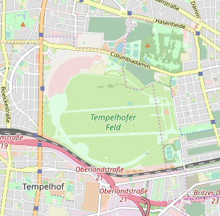
+1, I also suggest to look at huge buildings, for which z13 is already too late and creates a strange change when zooming from z12 to 13, e.g. the former Tempelhof airport, industrial buildings and so on.
dieterdreist
on 8 Aug 2018
As requested - former Tempelhof airport at z13 with current cleanup code (which BTW shows buildings on z15+, not z14+):
Before

After
kocio-pl
on 9 Aug 2018
Center of Rome at z13:
Before
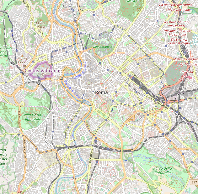
After

kocio-pl
on 9 Aug 2018
Warsaw at z13
Before
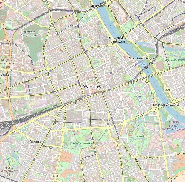
After

kocio-pl
on 9 Aug 2018
Dortmund at z13
Before

After

kocio-pl
on 9 Aug 2018
Hamburg at z13
Before

After

kocio-pl
on 9 Aug 2018
London at z13
Before

After

kocio-pl
on 9 Aug 2018
To be honest, I think that the removal of the buildings at these zoomlevels is going to be _highly_ controversial in the community. Showing buildings at a relatively early stage is one of the key benefits and differences with many other (vector) map styles of this style. I think you should announce this in some more open way than just in this repository if you desire to have real input on this idea.
 mboeringa
on 9 Aug 2018
mboeringa
on 9 Aug 2018
On z13 there are only single examples of buildings really visible, the rest is just making brown noise and is not really useful.
kocio-pl
on 9 Aug 2018
I agree Z13 is a kind of "breaking point" for displaying buildings. Still, there are many large structures that will disappear too. Hence I do think it wise to announce this wider if you truly wish to have more input on this major change.
mboeringa
on 9 Aug 2018
I guess it'll be mostly some industrial buildings, but I like showing industrial landuse instead more (south Hamburg looks better IMO) and this is still not that big change for me. But that's not my issue and you can do what you consider to be good.
kocio-pl
on 9 Aug 2018
sent from a phone
On 9. Aug 2018, at 12:42, kocio-pl notifications@github.com wrote:
On z13 there are only single examples of buildings really visible, the rest is just making brown noise and is not really useful
There are both, a few individual buildings that are recognizable and patterns of urban structure that are very useful for reading the city.
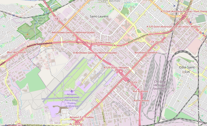
In some areas, the map would become extremely worse than it is now, for example: https://www.openstreetmap.org/#map=13/45.4815/-73.7089
I partly agree that the buildings are not very readable at z13 currently, but from my point of view this originates from the poor contrast with typical urban landuses and could be fixed with a darker building fill (also depends on latitude and building sizes and urban structure (detached/attached)).
dieterdreist
on 9 Aug 2018
For me it's the same as Hamburg case - looks better when I see the industrial area instead of all the industrial buildings:
Before
After

kocio-pl
on 9 Aug 2018
sent from a phone
On 9. Aug 2018, at 16:45, kocio-pl notifications@github.com wrote:
For me it's the same as Hamburg case - looks better when I see the industrial area instead of all the industrial buildings:
Before
After
I see the industrial area in both, but for me removing the buildings reduces the information content significantly, e.g. for orienteering. It depends what you want from the map of course. Less content is usually cleaner, agreed.
dieterdreist
on 9 Aug 2018
I'm not convinced by orienteering at all - first, there are multiple outdoor maps which might be better for this task, second - with proper landuse you should know that there is a industrial area around.
z13 would be the only zoom level where you can recognize different landuses without building clutter (z12 has general gray for builtup areas, z14 would have all the buildings) and I like this idea.
kocio-pl
on 13 Aug 2018
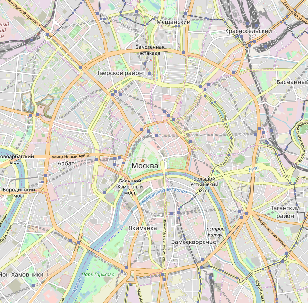
Another example - Moscow:
Before

After
kocio-pl
on 14 Aug 2018
If you drop the footways wouldn't it bad to have a good overview of the hiking ways in the wild?
 ximex
on 22 Aug 2018
ximex
on 22 Aug 2018
@ximex That ship has already sailed, I think. Since https://github.com/gravitystorm/openstreetmap-carto/pull/747 back in 2014 it's been impossible to use this style for a hiking map to visualise e.g. a 20km walk.
For good or ill the focus of the developers of this style is on central European cities (just look at the screenshots in the thread so far). People tend to scratch their own itch; that's understandable. It's not possible to have one map style that works well for every use case since some are contradictary (in fact, some of the goals of https://github.com/gravitystorm/openstreetmap-carto/blob/master/CARTOGRAPHY.md are too to some extent).
 SomeoneElseOSM
on 22 Aug 2018
SomeoneElseOSM
on 22 Aug 2018
It's not possible to have one map style that works well for every use case since some are contradictary (in fact, some of the goals of https://github.com/gravitystorm/openstreetmap-carto/blob/master/CARTOGRAPHY.md are too to some extent).
You are right if you say _it is not possible to have one map style that works well for every use case_ but i think you can also clearly say that it would be possible to do much better than this style does right now. The documented goals could be pretty helpful for that but practically it turned out to be unrealistic in most cases that they would actually help.
I should however mention that the goals were written when development here was still based on consensus so the spectrum of perceptions and priorities at least to some extent ensured some balance between the goals and some counterweight to special interests and narrow priorities.
 imagico
on 23 Aug 2018
imagico
on 23 Aug 2018
I believe the main obstacle for better coexistence of big cities and outdoor rendering is #1957 "equalizing" ticket being unresolved.
I think about "WMAs" (well-mapped areas), which are located in the big cities where mappers were active, that they make the biggest difference. They start to be very rich, because this is the reality, which was not well covered by mappers just a few years ago. We could rely on this incompleteness up to some point and render whatever was available without critically rethinking the whole system for years. But this is no longer true and the WMAs begin to be drastically more dense than outdoor areas. This is nobody's fault, it's just the unexpected consequence of the success of OSM in gathering all kind of data. Of course, we might stay with what we were showing before, but it's just closing eyes to avoid noticing the constant change of OSM data. Something like taking the snapshot of some past moment and refusing to take more current ones, just because it's more familiar for cartographers than trying to face these new challenges.
I like the outdoor rendering and when it doesn't hurt, I'm happy to make it also rich. There are places where we outperform typical (if not all) outdoor maps with details, like for example here:
https://www.openstreetmap.org/#map=17/47.35137/8.49157
But without some kind of equalizer (making rendering aware of a place context), it's absolutely not possible to find a visual balance between rural/urban environments. And when this inevitable moment of clash comes, I tend to care more about proper depicting WMAs than the outdoor.
Why?
There are already many outdoor maps in the wild, including some based on OSM data (Hike&Bike, OpenTopoMap, cycling maps etc.), which are better suited for such tasks as hiking, precisely because they are very limited by design. General, rich map is just not a competitor for them. And I don't even mention primary solution for such activities, which are Garmin-like devices packed with vector maps and geolocalization included.
Choosing the outdoor advantage is not just trying to play the wrong game, it also means clutter for WMAs with no hope for being readable. And these are the places where a lot of people might be interested in looking at the map. Rendering problem in the middle of Andes is still a problem, but for example visual mess in London is just much worse.
The last argument is that there are no special maps of WMAs. There might be hand-crafted maps of specific places, but no other general map style to reflect data richness. I believe they deserve to be shown as good as it's possible.
kocio-pl
on 23 Aug 2018
@kocio-pl - if that is the dominant opinion among currently active developers you should change the cartographic guidelines because what you write is fundamentally and ostentatiously in conflict with them.
imagico
on 23 Aug 2018
Could you point out these conflicts, at least the main ones?
I'm not sure whose opinion might it be beside myself, and this is kind of very fresh vision I got just recently as a result of experience with developing this style. As you probably remember, I'm OK with the goals that got into the guidelines and also I was quite sure they are still valid for me lately, I just have different interpretation of them and my goals were mainly related to the teamwork, not to the code or cartography. That's why I was not able to draft my view until now.
kocio-pl
on 23 Aug 2018
No, i won't discuss the goals yet again just to have you cherry pick the ones you like on a per-case basis and interpret them to support your interests while dismissing the rest. The guidelines are very clear in describing how they are meant to be used and my suggestion is that if you don't use them this way you should remove or change them. Saying you are OK with the goals if there is no need or even incentive to actually work towards the goals in substance is kind of cheap.
As said above already it is clear to me now that it was unrealistic that the guidelines would do any good with the current development model.
imagico
on 23 Aug 2018
OK. I just thought that if you see conflicts, you can show them, because I don't see them:
- "There is no fixed order of priorities" - maybe I could argue with this sentence, because "rich map" is more important to me than the rest, but "not fixed" means that prioritizing them myself is allowed, so I guess no conflict here.
- You have interpretation of "rich map" (more or less "the map is already rich, don't add more things") which is as good as mine ("the goal of a rich map is still ahead of us and it's just not possible to render thousand keys") - both are not violating "very clear" rules, so maybe they're not as clear as you'd like to, but there's no conflict for me with what is written.
- "These rules are not set in stone, they can change and they may not be followed in all cases" - so even written guidelines are not so strict after all and no need to change them.
You gave a written set of "dots", but no higher level idea than them (even if you have some in your head, I don't know that). I just connect these dots in some pattern and I have wrote about my higher level idea here, which explains how I see the dots. This is not contradicting in my view and I still prefer to do the team job than rephrase guidelines. However I think about writing some diary entries about how do I see this project now and what I've learned while developing it.
UPDATE: my first diary entry on this subject, which is just a copy of my long comment, has been published.
kocio-pl
on 23 Aug 2018
I think you just perfectly made my point.
imagico
on 23 Aug 2018
Well, now I really don't know what do you mean, because I have just shown it's not contradicting, as you claim.
kocio-pl
on 23 Aug 2018
2018-08-23 15:01 GMT+02:00 kocio-pl notifications@github.com:
>
- "These rules are not set in stone, they can change and they may not
be followed in all cases" - so even written guidelines are not so strict
after all and no need to change them.
if we hold up this way of reading, I agree with Christoph it would be more
honest to abolish all rules all together, because if you reserve the right
to not act according to them in some cases, you end up in the same
situation as not having them and being frank about this seems more
transparent.
dieterdreist
on 24 Aug 2018
OK, it sounds reasonable to me. I don't think abolishing is the right way, rather rearranging.
Anyway I need some time to gather all my experiences and write about them. Another thing is if other people will agree with my visions and goals. But discussion about such things should go to #1975, not in this ticket, so let's continue this thread there.
kocio-pl
on 24 Aug 2018
Any chance of getting rid of streams at Z13? They are way to prominent at that level in places where there are a lot of them. Plus, %99 of the time they aren't major features like roads or landuse. A lot of them are pretty tiny and don't have water most of the time. Otherwise, they would be tagged as rivers.
 Adamant36
on 13 Sep 2018
Adamant36
on 13 Sep 2018
A lot of them are pretty tiny and don't have water most of the time.
Note that it strongly depends on a region.
don't have water most of the time
Are such waterways already tagged with intermittent=yes?
matkoniecz
on 13 Sep 2018
@matkoniecz, of course it does. As does everything though. Although if they aren't small features, they can/should still be tagged as rivers. Your the one that told me as much in the first place. According the wiki, a stream is something a healthy person can jump across. From the research I have found, the world record for jumping distance is 29 feet 4 inches (the width of a residential street btw). That was a long jump expert. So what could a normal person jump? Like 10 feet? Id hardly call anything 10 feet or less then that a major feature. Personally, I think its a dumb way to classify something, as a 12 foot wide waterway that can't be jumped over shouldn't be classified as a river, but any complaints I have about it clearly don't matter and I don't have a better idea anyway.
Either way, making them not view able on z13 would at least fit with @kocio-pl's "mapping things based on size" thing. Plus, know one is going to be concerned with a 5 foot wide dry creek at that zoom level. Especially since it gets in the way of seeing track/residential roads. Really, Id put them in the same category as driveways/parking isles/general service roads/power lines etc in importance and size. None of which are shown yet at z13.
And yes they are tagged as intermittent. It doesn't make a difference and probably makes it worse in some places if anything.
Adamant36
on 13 Sep 2018
Footpaths and track roads also become visible at z13. Most streams are as
wide as a footpath, and many are as wide as a track road. Streams can be
several kilometers long, depending on rainfall. Considering that even a
full-size screen view is only a few kilometers across at z13 in the high
latitudes, it is useful to be able to see these for planning outdoor trips
in rural and wilderness areas. So I don't think it makes sense to avoid
rendering streams at z13, if footpaths and tracks are shown then (and they
should be)
However, I would agree with not rendering intermittent streams until z14.
(Ideally intermitttent streams could be still be rendered at z13 only in
desert or semi-arid regions, but I don't believe this is feasible.)
Joseph
On Thu, Sep 13, 2018 at 12:34 PM Adamant36 notifications@github.com wrote:
@matkoniecz https://github.com/matkoniecz, of course it does. As does
everything though. Although if they aren't small features, they can/should
still be tagged as rivers. Your the one that told me as much in the first
place. According the wiki, a stream is something a healthy person can jump
across. From the research I have found, the world record for jumping
distance is 29 feet 4 inches (the width of a residential street btw). That
was a long jump expert. So what could a normal person jump? Like 10 feet?
Id hardly call anything 10 feet or less then that a major feature.
Personally, I think its a dumb way to classify something, as a 12 foot wide
waterway that can't be jumped over shouldn't be classified as a river, but
any complaints I have about it clearly don't matter and I don't have a
better idea anyway.Either way, making them not view able on z13 would at least fit with
@kocio-pl https://github.com/kocio-pl's "mapping things based on size"
thing. Plus, know one is going to be concerned with a 5 foot wide dry creek
at that zoom level. Especially since it gets in the way of seeing
track/residential roads. Really, Id put them in the same category as
driveways/parking isles/general service roads/power lines etc in importance
and size. None of which are shown yet at z13.And yes they are tagged as intermittent. It doesn't make a difference and
probably makes it worse in some places if anything.—
You are receiving this because you are subscribed to this thread.
Reply to this email directly, view it on GitHub
https://github.com/gravitystorm/openstreetmap-carto/issues/3331#issuecomment-420872442,
or mute the thread
https://github.com/notifications/unsubscribe-auth/AoxshESOZ2yB4Z-MkEYPZdOruZLSuQk9ks5uadJOgaJpZM4VvihV
.
 jeisenbe
on 13 Sep 2018
jeisenbe
on 13 Sep 2018
@jeisenbe, I could go with that. My main issue is with intermittent ones.
Adamant36
on 13 Sep 2018
Great. Do you have a link to a place where too many intermittent are
displayed, currently?
I wonder it they might be due to bad data imports in some places.
I recall that the hills in Southern Oregon show too many streams, but they
are all from automated imports.
It looks like every low spot was shown as a stream, though many of these
only flow with the biggest winter storms:
https://www.openstreetmap.org/#map=14/42.2655/-122.9990
On Thu, Sep 13, 2018 at 1:27 PM Adamant36 notifications@github.com wrote:
@jeisenbe https://github.com/jeisenbe, I could go with that. My main
issue is with intermittent ones.—
You are receiving this because you were mentioned.
Reply to this email directly, view it on GitHub
https://github.com/gravitystorm/openstreetmap-carto/issues/3331#issuecomment-420879421,
or mute the thread
https://github.com/notifications/unsubscribe-auth/AoxshF9Yf6VxUYDGr8BaOjmfD5vec3Mlks5uad6rgaJpZM4VvihV
.
jeisenbe
on 13 Sep 2018
@jeisenbe, Sure. There's this gem of an area in northern California that's a lot like the example you gave. Its probably from the same bad import you linked to. The NHD data that it is based on used LIDAR to map stream and its still considered an experimental technique. So it probably never should have been imported. https://www.openstreetmap.org/#map=13/40.0469/-122.6407
Although I agree that was from a bad import and most of those probably aren't streams, I was advised by people on the forum not to delete them unfortunately. So I just have to live with it. Therefore, I am more talking about places like here https://www.openstreetmap.org/#map=13/40.4339/-122.3867, here https://www.openstreetmap.org/#map=13/40.5482/-122.4785,
here https://www.openstreetmap.org/#map=13/40.5298/-122.1973, https://www.openstreetmap.org/#map=13/41.0175/-122.1381 etc.
It would also be useful further up north in areas like above the lake here https://www.openstreetmap.org/#map=13/40.9137/-122.1505, most of those places do actually have streams as mapped. Although they hardly count as geographical features and are dry 99% of the time. They still can't be deleted though and cause problems with viewing things like track roads that intersect them at that zoom level. Although a case could be made that southern Oregon/northern California is an exception due to the overall denseness, I still think there would be merit to not displaying intermittent streams at z13 in areas where they are not as thick/is deserts/etc. As they still aren't major features or high priority in most cases. If they have water year round fine though. I can see merit in that.
Adamant36
on 13 Sep 2018
Although I agree that was from a bad import and most of those probably aren't streams, I was advised by people on the forum not to delete them unfortunately.
Nobody can tell you to "not delete them". This is OSM, nobody is really in charge.
If this data is from
- a poorly/undocumented or poorly executed import
- the data license is unclear
- the data entered is disputable or simply bad geometrically or otherwise
then please do remove or enhance the data by editing it. Leaving rubbish just because the data appears "detailed" or extents over large areas / involves many features, is ultimately of help to nobody (and certainly not to any data consumer or cartographer wishing to use the data)
mboeringa
on 13 Sep 2018
@mboeringa, Thanks. Although I completely agree with you, according to Frederik Ramm the number one rule of OSM is not to do anything that upsets people and more then likely its not worth the judgmental messages I'll probably receive afterwords from people like him or @matkoniecz, who disagree with us, for doing something I was told not to. Bad imports aside, I still think there is merit in not showing intermittent streams at z13.
Adamant36
on 13 Sep 2018
sent from a phone
On 13. Sep 2018, at 03:35, Adamant36 notifications@github.com wrote:
Plus, %99 of the time they aren't major features like roads or landuse.
they are significant features for reading the landscape as they tell the elevation / structure
dieterdreist
on 13 Sep 2018
If you verify every stream on good aerial imagery, I don't see an objection
to removing features that clearly do not exist. However, it is pretty
difficult to disprove the exitence of an intermittent stream from aerial
imagery alone, so caution is reasonable.
I believe marking the imported streams as "intermittent", when they cannot
be verified on satellite imagery, would be acceptable. I'll probably be
more inclinded to do it myself, if it means they won't render on z13, so
good call on that.
On Thu, Sep 13, 2018 at 3:33 PM Adamant36 notifications@github.com wrote:
@mboeringa https://github.com/mboeringa, Thanks. Although I completely
agree with you, according to Frederik Ramm the number one rule of OSM is
not to do anything that upsets people and more then likely its not worth
the judgmental messages I'll probably receive afterwords from people like
him or @matkoniecz https://github.com/matkoniecz, who disagree with us,
for doing something I was told not to. Bad imports aside, I still think
there is merit in not showing intermittent streams at z13.—
You are receiving this because you were mentioned.
Reply to this email directly, view it on GitHub
https://github.com/gravitystorm/openstreetmap-carto/issues/3331#issuecomment-420899061,
or mute the thread
https://github.com/notifications/unsubscribe-auth/AoxshE5eaUmO-JxZbztzdiBOx2Jm-h1tks5uafwhgaJpZM4VvihV
.
jeisenbe
on 13 Sep 2018
- Buildings - I don't see them as a problem. IMHO all above examples look better with them, but that may be just me. With vector tiles we could remove buildings for rendering efficiency reasons but that's not an issue with raster tiles. We could perhaps use transparency instead of contrast to reveal more of the underlying landuse color (that could also be helpful with tunnels under buildings etc) but I don't think building are currently too prominent.
- Paths - I am not a fan of red and blue rendering. It is indeed a bit too prominent at lower zoom levels but that could be avoided by rendering paths in white - less prominent, more consistent with roads, more consistent with other maps.
One more thing: removing information (here: buildings) with an intention of forcing mappers to add alternative information (landuse) is _bad_. We are an open data project so even a hint of coercion can be very damaging.
 andrzej-r
on 27 Sep 2018
andrzej-r
on 27 Sep 2018
Thanks for all feedback.
I don't think I'm able to come up with a good idea for cycleways now, so I'm leaving these outside scope for now.
matthijsmelissen
on 7 Oct 2018
Related issues
 FTno
·
4Comments
Tomasz-W
·
4Comments
FTno
·
4Comments
Tomasz-W
·
4Comments
 HolgerJeromin
·
3Comments
HolgerJeromin
·
3Comments
 MarkusStue
·
4Comments
kocio-pl
·
4Comments
MarkusStue
·
4Comments
kocio-pl
·
4Comments
Most helpful comment
I think that poor rendering of residential areas without mapped landuse is not a problem, it is rather a benefit.