Openstreetmap-carto: Add rendering to landcover=grass and landcover=trees
landcover= was proposed by @dieterdreist in 2010, and two of the values are in significant use meanwhile, landcover=trees (9632) and landcover=grass (6273). Landcover= is an orthogonal definition to landuse=*, allowing to map the physical cover as opposed to the actual use of the land.
The reason that these two values are flying already, is that the current use of landuse=grass and landuse=forest is a misnomer in many cases where small areas covered with grass or trees within a real landuse are to be tagged. CF the recent discussion on the tagging list.
I guess the key needs to wait for the database layout change, however I suggest that we already discuss how to render. My proposal is, initially, to render the same as other grass rendering (see #1372) and wood/forest.
 polarbearing
All 113 comments
I have no definitive opinion on this at the moment but the mere use numbers say very little about how widely these tags are accepted in mapping and what they are used for.
It would be important to:
- know how many of the features with this tag carry another area tag we already render and which would therefore not be rendered differently.
- know how many mappers are using this tag - spatial distribution in taginfo indicates concentration on central Europe for both tags but this might be by just a handful of mappers or thousands.
- have a clear definition of the tags on the wiki including practical instructions when to use these tags and not more established ones.
Especially the last point is important IMO since we should not support meaningless proliferation of tags, i.e. creation of synonyms without a difference in meaning in practical use. Especially for trees the different opinions on the meaning of common tags seem to already cover what landcover=trees is meant to indicate. See also xkcd.
 imagico
on 13 Jan 2017
imagico
on 13 Jan 2017
sent from a phone
On 13 Jan 2017, at 20:19, Christoph Hormann notifications@github.com wrote:
Especially the last point is important IMO since we should not support meaningless proliferation of tags, i.e. creation of synonyms without a difference in meaning in practical use.
IMHO there will indeed be not so much difference because of people abusing landuse=forest or natural=wood for any spot with more than 1-2 trees, because it's the only way to map groups of trees that is supported by this style (needless to point out that this is tagging for the renderer in its purest form), although the word "forest" implies more than just some trees (think soil, microclimate, etc.). Landuse=grass is another glorious fail, whatever definitions are written in the wiki, it just doesn't make sense on a semantic level, grass is not a use, and the originally defined scope (grass as part of highways) would better be expressed by landuse=highway and a landcover tag.
 dieterdreist
on 13 Jan 2017
dieterdreist
on 13 Jan 2017
Objects with this key were last edited by 1 080 different users. = 216 full hands.
polarbearing
on 13 Jan 2017
because it's the only way to map groups of trees that is supported by this style
Don't put this all on this style. Styling decisions here affect mapping practice but they are not the only influence.
This style aims to support mappers in consistent use of tags. But it should not be our aim to push new tags against existing ones in pursuit of more systematic key semantics. So if landcover=grass and landcover=trees are actually improvements over existing tags both in definition and in practical use (like leaf_cycle/leaf_type compared to wood=*) we should support them but not if they are just a rebranded version of the smallest common denominator of natural=wood/landuse=forest and natural=grassland/landuse=grass/meadow.
So the question to ask is probably: Does landcover=trees indicate anything that is not also indicated by natural=wood and landuse=forest?
Personally i think it is more important to show additional tags specifying additional information on such areas (like the mentioned leaf_cycle/leaf_type) but that of course in no way conflicts with the subject of this issue.
would better be expressed by landuse=highway and a landcover tag
We don't currently render landuse=highway i think but in general if we add rendering of landcover=grass and landcover=trees i don't think this should supersede other area tags we render (like natural/landuse/leisure etc.)
imagico
on 13 Jan 2017
The issue probably is that if you have some main landuse (e.g. residential or farmland) and you put a patch of trees onto it via landuse=forest, but logically you still want the original landuse to be at that spot logically (even more supported by the transparent forest rendering now (e.g. you can have trees and water at the same place)). But algorithmically, you can't have 2 landuses at the same place, so probably the forest wins in applications. Landcover fixes this problem, you can have a semantical landuse at a place, but there is physically a patch of trees (landcover). I support the idea of the new tags.
 aceman444
on 13 Jan 2017
aceman444
on 13 Jan 2017
@polarbearing - that is a useful first indicator but number of people who last touched a feature with a certain tag is not the same as the number of active users of course.
@aceman444 - within this style the key used does not really have an influence here - we order by way_area independent of the key used. So if we'd add support for rendering landcover=trees it would not matter if you'd tag an area natural=wood or landcover=trees - it would render the same. I don't know of any other applications that have a problem with overlapping areas using the same key either, this happens so often in real life data that such an application would be pretty useless.
imagico
on 13 Jan 2017
I liked the more comprehensive proposal by Rudolf more. It's also based on scientific classifications categories.
 jojo4u
on 13 Jan 2017
jojo4u
on 13 Jan 2017
@imagico but logically it is nonsense to have overlapping areas, unless they really have both properties (like natural=water+natural=wood). But you can't have landuse=residential+landuse=forest at the same spot. That such data exists looks like bad mapping, sometimes caused by the bad existings tags (like you only have landuse=grass at your disposal, natural=grass is something else).
aceman444
on 13 Jan 2017
Please leave the tagging discussion out of this.
imagico
on 14 Jan 2017
we should not support meaningless proliferation of tags, i.e. creation of synonyms without a difference in meaning in practical use. Especially for trees the different opinions on the meaning of common tags seem to already cover what landcover=trees is meant to indicate.
👍
 pnorman
on 14 Jan 2017
pnorman
on 14 Jan 2017
sent from a phone
On 14 Jan 2017, at 14:47, Paul Norman notifications@github.com wrote:
Especially for trees the different opinions on the meaning of common tags seem to already cover what landcover=trees is meant to indicate.
I think we can say that we don't have any clear idea how to tag the difference of a forest and a group of trees. We also can't tell whether there are actually trees currently or if the whole forest has been cut down recently and is currently being reforested. At most our "forests" can be either some trees or an area with forest landuse. Personally I would be interested to change this and get to clearer definitions when to apply which tags, and I feel that I'm not alone here, but as long as being more accurate (by omitting the landuse=forest tag) will lead to vanishing the objects from the main map it is unlikely that more than a handful of hardcore mappers will do it
dieterdreist
on 14 Jan 2017
I feel this is result of taking this purpose to the extreme:
It's an important feedback mechanism for mappers to validate their edits and helps to prevent unfavorable fragmentation of tag use.
Guarding against unfavorable fragmentation is so hard, that we forget it can be favorable in some cases (like making important changes in tagging without breaking things). And because this style is not only about "consuming" data, but also about giving feedback, it's in effect _invalidating_ any change.
 kocio-pl
on 14 Jan 2017
kocio-pl
on 14 Jan 2017
I feel this is result of taking this purpose to the extreme
So far i don't think anyone has suggested anything extreme in this thread.
imagico
on 14 Jan 2017
Do you consider any fragmentation favorable at all?
kocio-pl
on 14 Jan 2017
I think i made my view quite clear:
we should not support meaningless proliferation of tags, i.e. creation of synonyms without a difference in meaning in practical use.
This style aims to support mappers in consistent use of tags. But it should not be our aim to push new tags against existing ones in pursuit of more systematic key semantics.
If and how this applies to the tags suggested in this issue i don't know yet - which is why i mentioned above that additional information would be important.
imagico
on 14 Jan 2017
I understand only that you are trying to keep things consistent (and that was clear from the beginning). But I still don't know if you ever consider any tag fragmentation useful (in particular to help make tag change smooth)?
kocio-pl
on 14 Jan 2017
The term is from @nebulon42 IIRC - in the context it is used in there i read it as meaning the same as what i described with _meaningless proliferation of tags_.
imagico
on 14 Jan 2017
A couple of considerations here:
- Like others pointed out: landuse=forest and landuse=grass are more or less de-facto already used as "landcover". I know there are issues, but I do think this is the general trend.
- Many other styles interpret these tags in a similar way as Carto. Making a breaking change - or at least one that potentially has a big impact on how people will tag these features in the future - in Carto, will mean a lot of others styles will need to follow suit. Therefore, this is not just about this style, but a wider issue.
What I totally miss in the discussion regarding landuse / landcover, is that the main problem regarding the current use of landuse=forest/grass is not so much the fact that people use it as landcover while the word "landuse" reflects a legal or administrative status related to some "boundary", but that there is no tagging scheme for these type of "administrative boundaries" not in the hierarchy of "countries/states/districts/provinces etc"...
Instead of developing an alternative landcover=x, I think it would be more logical to develop a new tagging scheme for these types of "administrative / legal / management / toponym boundaries" currently not supported in any of the regular tagging schemes.
 mboeringa
on 14 Jan 2017
mboeringa
on 14 Jan 2017
My question was as wide as possible and I still don't understand: is there anything that could be more important to you than strict consistency? I try to get where the common ground could be, and what circumstances could be legitimate as an exception from this rule? I understand you don't find such exception now - but what would be enough for you to accept it?
kocio-pl
on 15 Jan 2017
Can we have some examples of this where landcover and landuse are used in parallel? Note that the Netherlands had a not-so-good import so this might not be the best example.
I'm in particular in interested in the intended usecase of the people who liked this issue - @kocio-pl, @d1g, @stragu, @de-vries, and @Tomasz-W.
My personal opinion: I don't see a real difference between landcover=grass and landuse=grass. Note that the latter is about 500 times as popular.
 matthijsmelissen
on 22 Jul 2017
matthijsmelissen
on 22 Jul 2017
@math1985 For me, it's about mess with tags in OSM. Tags for physical covers of ground (eg. grass, meadow, etc.) should be separated from tags describing usage of this terrain (non-physical, eg. residential, industial, etc.). It wasn't separeted at the beginning, so now a lot of mappers are confused by mixed functions of this 3 keys: landuse=, natural=, surface=*. In this situation, I think that allowing landcover tags is a step in good direction, and a chance to get rid of doubts for mappers in future.
More here: http://wiki.openstreetmap.org/wiki/Landcover
 Tomasz-W
on 22 Jul 2017
Tomasz-W
on 22 Jul 2017
@math1985 maybe e.g. if you want a patch of grass (or trees) in a landuse=residential, having landuse=grass inside landuse=residential is a bit against logic. Every spot should probably only have a single landuse defined, not a stack of landuses. Would you exclude that patch of grass from the residential landuse via a multipolygon? No, nobody does that. Using landcover solves this problem. There can be a landuse defined for a spot, but there may be different things on the ground in reality.
You can see this already in carto where landuse=forest was actually changed to mean landcover and now draws trees on top of residential landuse, water, whatever.
aceman444
on 22 Jul 2017
I still don't think I fully understand this. Do you guys propose replacing the tag landuse=grass entirely with landcover=grass? Or are there situations were landuse=grass is appropriate?
matthijsmelissen
on 23 Jul 2017
Honestly, I don't think this is going to solve anything. The problems of missing administrative / legal / management / toponym "boundary" types not defined in the Wiki, are not going to be solved.
The main Wiki page of the landcover key (http://wiki.openstreetmap.org/wiki/Landcover) itself is poor as well. It doesn't actually list a good consistent tagging proposal, but instead resorts to listing existing practices and displaying a series of (international) classifications of landcover (NLCD92, LCCS), that have no real relation with OpenStreetMap and current mapping practices. This is highly confusing and will lead to inconsistent tagging, it is simply unclear what any user should do with this information only superficially related to OSM.
Only on second inspection can you end up on the proposal pages, that seem better defined. However, again, the pages don't solve the "boundary" type problem. They even re-define tags like landuse=forest as going to be deprecated by landcover=trees. This misses the whole point of administrative or legal boundaries (e.g. _forest area X managed by company or government agency Y and named Z_).
It is likely that we will end up with just another key that has the same problems as the existing natural and landuse keys, that is: administrative, management and legal boundaries and landcover tags intermingled and tagged on the same OSM node / way / relation features.
Considering this switch will have a huge impact on many map styles, and leads to even more fragmentation in tagging practices in a likely _long_ transition period, I am not convinced of its merits given these unsolved shortcomings.
mboeringa
on 23 Jul 2017
I've made initial coding for this issue, but it's not working currently and I plan to take a second look later, so it's still not ready for PR:
https://github.com/gravitystorm/openstreetmap-carto/compare/master...kocio-pl:landcover
kocio-pl
on 16 Sep 2017
@kocio-pl Please note that we haven't decided on whether or not to implement this. I'm inclined towards a no.
matthijsmelissen
on 16 Sep 2017
I'm fully aware of it, but given that the issue is still not closed as "wontfix" I just wanted to try, because sometimes the discussions tend to stall for a long time - and the last comment here was 2 months ago.
kocio-pl
on 16 Sep 2017
@kocio-pl Please note that we haven't decided on whether or not to implement this. I'm inclined towards a no.
Likewise. Given the views expressed, I'm going to close this. I do this realizing some people are passionate about this particular tagging and they won't be happy.
Some points of particular importance
- Other tags are used to indicate areas with trees 700x more frequently than landcover=trees
- It is not be our aim to push new tags against existing ones in pursuit of more systematic key semantics
- Current tagging practices for areas with trees are messy, with different people having different views on what the tags mean. This limits what you can infer from the data.
- this switch would have a huge impact on many map styles
- Issues have been raised with the tagging practices, which need discussing elsewhere, then to be generally accepted and used. These tagging issues are outside osm-carto
- No one is particularly satisfied with the current situation
pnorman
on 17 Sep 2017
@pnorman , you mention 6 points and from my point of view, they speak more in favor of rendering landcover tags than against:
- yes, other tags are used more often
- there are objects with the tag, by now 26000 and constantly growing, this is not few for a tag that isn't rendered (let's face it, people do tag for the renderer).
- seems to be read as in favor of landcover (or not, at least it had a clear definition before it was used)
- we are not discussing a "switch" but adding (additionally) support for another couple of tags. It would not impact other map styles at all
- is basically the same as 3
- is again in favor of at least any change (that doesn't make things worse)
dieterdreist
on 1 Dec 2017
I don't feel the issue has been resolved in any way and there are new arguments, so I reopen it.
kocio-pl
on 2 Dec 2017
reference to #2796
Tomasz-W
on 2 Dec 2017
The areas tagged as landcover=trees are useful to represent groups of urban trees and parks, but actually is not visible on the render.
Now we have landuse=forest and natural=wood, but neither is applicable to urban areas. In the cities do not exist forestal explotations or woodlands.
 CarlosBrys
on 20 Feb 2018
CarlosBrys
on 20 Feb 2018
I'm in favor for landcover=grass; as this could be used to indicates a patch of public grass within a residential area, or to micromap a park with the different surface covers; or for example stretches of grass within school grounds.
landuse=grass indicates that the land is actually used to grow grass (e.g. for feeding cattle in the winter), whereas natural=grass would indicate a place where no human are, but grass grows.
In other words, I'm all in and will even start changing a few stretches of landuse=grass to landcover where appropriate. And yes, this will be a long transition, but we'll have to make it anyway, and the longer we wait, the more difficult it becomes!
So go for it!
 pietervdvn
on 21 Feb 2018
pietervdvn
on 21 Feb 2018
I would like to remind everyone that this is not the place to discuss tagging ideas. Statements like
Now we have landuse=forest and natural=wood, but neither is applicable to urban areas.
I'm in favor for landcover=grass; as this could be used to indicates a patch of public grass within [...]
are off topic here since they discuss tagging ideas (i.e. opinions what tags are supposed to be used for what purposes). This style has the declared goal to support mappers in consistent use of tags meaning it can and should try to render tags that are consistently used. But it has no mandate to pressure mappers to change existing and consistent mapping habits no matter how strongly a vocal group of people believes OSM would be better if they did.
So if you think that landcover=grass or landcover=trees are practically used in a way that is more than the smallest common denominator of various other much more common tags please show that here. But please don't try to spread the religion-like dogmatism that dominates the tagging discussion and prevents even a meaningful and useful documentation of tag use on the wiki (see https://wiki.openstreetmap.org/w/index.php?title=Tag:landcover%3Dgrass&action=history for example) to map rendering.
imagico
on 21 Feb 2018
There is not a tagging discuss. It's a justification for what is important to render the landcover=trees like others.
CarlosBrys
on 21 Feb 2018
two of the values are in significant use
I would note thatlandcover=trees is still less than 1% of landuse=forest (31k https://taginfo.openstreetmap.org/tags/landcover=trees vs 3585k https://taginfo.openstreetmap.org/tags/landuse=forest)
For grass it is 10k (https://taginfo.openstreetmap.org/tags/landcover=grass) vs 2657k (https://taginfo.openstreetmap.org/tags/landuse=grass) for 266x ratio.
2019-03:
13k ( https://taginfo.openstreetmap.org/tags/landcover=grass ) vs 2966k ( https://taginfo.openstreetmap.org/tags/landuse=grass ) for 228x ratio.
 matkoniecz
on 7 Jun 2018
matkoniecz
on 7 Jun 2018
My opinion prompted by the mailing list discussion:
I am unwilling to promote highly-controversial tag that duplicates currently existing tags, is generally not supported and is discussed rather than used.
Note that AFAIK it is not supported both by nearly all data consumers and by editors (when I checked there was no even third-party support via presets).
I am not fan of using openstreetmap-carto as way to force somebodys favourite controversial tag scheme.
matkoniecz
on 7 Jun 2018
I tried to keep an open mind to this for a long time (as indicated in my initial comment here) but i now concur that these tags should not be rendered. Deciding factors for me - apart from what has already been discussed - are
- that the tags in question remain just a different way to express the smallest common denominator of natural=wood/landuse=forest and natural=grassland/landuse=grass/meadow and no attempt has been made to change that or even honestly communicate this fact for a long time now.
- that many of the voices expressing desire to have these tags rendered are clearly more motivated by using this map style as a vehicle to push their ideas of a different tagging system than by the desire to improve the map and supporting mappers in consistent use of tags as it is the mission of this style. Recent discussion on the tagging ML to me showed an alarming lack of ability or willingness of some to accept that the vast majority of mappers do not share their beliefs regarding key systematics. This is something this project cannot support if it wants to remain a voice for a diverse, tolerant and open (and yes, also in a way anarchic) OSM community.
From my perspective this does not necessarily permanently dismiss the tags in question although the mentioned unbalanced discourse on the matter has of course kind of burnt the landcover key by associating it with the beliefs regarding key systematics that have developed around it.
There are many ways to improve and better differentiate mapping of grass and woodland and many options to show this in a map. My suggestion is to concentrate on these things, improving mapping in substance rather than splitting hairs about using the right keys to describe something mappers have already decided how they want to describe in millions of instances.
imagico
on 8 Jun 2018
Closing per @imagico especially
are clearly more motivated by using this map style as a vehicle to push their ideas of a different tagging system than by the desire to improve the map and supporting mappers in consistent use of tags as it is the mission of this style. Recent discussion on the tagging ML to me showed an alarming lack of ability or willingness of some to accept that the vast majority of mappers do not share their beliefs regarding key systematics. This is something this project cannot support if it wants to remain a voice for a diverse, tolerant and open (and yes, also in a way anarchic) OSM community.
matkoniecz
on 8 Jun 2018
2018-06-08 10:29 GMT+02:00 Mateusz Konieczny notifications@github.com:
Closing per @imagico https://github.com/imagico especially
are clearly more motivated by using this map style as a vehicle to push
their ideas of a different tagging system than by the desire to improve the
map and supporting mappers in consistent use of tags as it is the mission
of this style.
this affirmation ("improve the map and supporting mappers in consistent use
of tags as it is the mission of this style") sounds ridiculous as reason
for rejection of landcover in the context of forest and tree mapping, as
you have stated yourself that the documented differences between
natural=wood and landuse=forest and their documented meaning is not
consistently applied, i.e. all kind of tree covered areas get one of those
2 tags (so it is rendered by this style). IMHO this is a direct consequence
of not having supported alternative, neutral tags (landuse) for a long
time. I agree it might be too late now for landcover to make a difference
and to allow distinction without having things automatically disappearing
from the rendering. Maybe we will have to introduce new tags for details
about forests or to state that something is really a forest and not just a
bunch of trees, etc.
Recent discussion on the tagging ML to me showed an alarming lack of
ability or willingness of some to accept that the vast majority of mappers
do not share their beliefs regarding key systematics.
truth is, iD does not support it -> 61% (2017) of mappers will not set the
tag, osm-carto does not support it: most mappers will not use the tag. JOSM
does not have a preset either.
I would see it like this: the majority of mappers does not care about tags
in general, they will happily use whatever renders and is offered by
presets (often even without noticing the tags that are set in the
background after selecting the preset), nonetheless, even as no major
application used or evaluated this tag, numbers are still growing.
Certainly there would be an incredible boost if this would be rendered.
This is something this project cannot support if it wants to remain a
voice for a diverse, tolerant and open (and yes, also in a way anarchic)
OSM community.
IMHO it would cost us nothing and would create a lot of potential, if we
supported the landcover tag as declaredly smallest common denominator for
tree covered areas, without any semantic issues wrt to key definitions
(landUSE). This would be a statement of diversity, tolerance and openness.
And in a way anarchy.
I guess the real reason for @imagico's rejection is the fear that people
would use landcover "to color the map" or "copy the aerial imagery", i.e.
just look at the kind of surface cover or vegetation and describe these
physical characteristics, possible disregarding other classes of
information like landuse. I can assure you, this fear is baseless, it is
already happening, people do not need the "landcover" key to render in
order to work like this.
dieterdreist
on 20 Jun 2018
I will respond to other raised issues, but not immediately (it may take quite a long time, sorry for that).
But I want to clarify one issue:
people would use landcover "to color the map" or "copy the aerial imagery", i.e. just look at the kind of surface cover or vegetation and describe these physical characteristics
I am not @imagico but I am pretty sure that it is not a problem. That is exactly how landcover recording would work (and how landuse=forest + natural=wood are used currently).
There was a person that claimed that people with different opinion tag for renderer and just want to colour map and are misuing tags and used other pejorative expressions but that was one of landcover advocates.
matkoniecz
on 20 Jun 2018
I would rather reopen the discussion, since it's alive. Closing it abruptly in the middle of the hot issue is not reflecting the state of things. Even if landuse is not the final solution, the discussion is here and one can change the subject to make it more appropriate.
that the tags in question remain just a different way to express the smallest common denominator of natural=wood/landuse=forest and natural=grassland/landuse=grass/meadow and no attempt has been made to change that or even honestly communicate this fact for a long time now.
I try to be as clear as it's possible that we need more general tags when the details are unknown.
It's more than just a common denominator, it's also a way to say "I don't know exactly", which is good for the database quality. Using specific tagging for general cases is misleading and simply wrong. This is certainly not splitting hairs, it's a systematic error of hiding classification problems ("it's an animal for sure - but dog or cat, or probably rather cow? Well, I don't have an animal nor cow category really, so let's make a random choice it's dog or cat, because we have them!").
that many of the voices expressing desire to have these tags rendered are clearly more motivated by using this map style as a vehicle to push their ideas of a different tagging system than by the desire to improve the map and supporting mappers in consistent use of tags as it is the mission of this style.
Lack of consistency between existing tags is evident and more alarming (well, maybe just hidden and forgotten).
Maybe we should start with removing them then, because it clearly makes unwanted tags fragmentation, and for a long time? Since they are not clearly defined, and we tend to be very strict about it, why we keep them - and render both of them?
Recent discussion on the tagging ML to me showed an alarming lack of ability or willingness of some to accept that the vast majority of mappers do not share their beliefs regarding key systematics. This is something this project cannot support if it wants to remain a voice for a diverse, tolerant and open (and yes, also in a way anarchic) OSM community.
Tolerant is about being open, not closing the doors with "no, old is better because it's old!". Anarchic database - yes, strict few persons view on rendering - more so; how do you think this is coherent vision? I don't and vote for more systematic tags (more relying on documentation and meaning) and also more systematic rendering (less debating single items without the context).
kocio-pl
on 20 Jun 2018
I intervene again to try to explain with examples what I asked before about rendering the areas covered with trees.
In particular, the need to render urban areas with tree coverage, for example squares and parks.
Today only two labels render these areas, and they are natural=wood and landuse=forest and neither reflects the reality.
Because a group of trees in a square and other urban areas do not constitute a forest, nor are they a forest plantation. They are grouped trees, and that's why I ask you to renderize landcover=trees
Respecting what the wiki says at: https://wiki.openstreetmap.org/wiki/Good_practice#Don.27t_map_for_the_renderer
"Draw things the way they are on the ground - do not enter incorrect data"
Well, an urban square is not a forest, nor a forest plantation. Clearly it is soil covered with trees.
CarlosBrys
on 20 Jun 2018
To make this perfectly clear once more: I have been very considerate in what i wrote above and i think i have been very clear in both my analysis and my conclusions.
And i won't engage in further discussions on this matter here with people who are unwilling to engage in serious non-superficial arguments in those aspects i - and others - have clearly explained to be the key issues.
If you don't understand what i am saying (which is very likely the case when you find it ridiculous or irrelevant) just ask. If you want to ignore or dismiss what i wrote because it does not fit into the way you see things just ignore it. But please don't try interpreting my deeper motives or to distort my statements or pick out isolated formulations to be able to more easily dismiss them.
And also once more: This is the issue tracker of a map style. Discussions on what tags should be used for what purpose, what tags are missing and needed - no matter how important and relevant they are - do not belong here, please take them somewhere else. Here ultimately the only significant question about tags is what they are practically used for.
imagico
on 20 Jun 2018
You said that your last formulation was about "deciding factors" and I think they are wrong, so I discuss with them. Could you elaborate what is more substantial for your opinion then, so I could discuss with them too?
kocio-pl
on 20 Jun 2018
this affirmation ("improve the map and supporting mappers in consistent use of tags as it is the mission of this style") sounds ridiculous as reason for rejection of landcover in the context of forest and tree mapping, as you have stated yourself that the documented differences between natural=wood and landuse=forest and their documented meaning is not consistently applied, i.e. all kind of tree covered areas get one of those 2 tags (so it is rendered by this style). IMHO this is a direct consequence of not having supported alternative
Especially in case of controversial tags like landcover=* - I am against using this map style as sole way to promote it. From what I see nobody made preset for JOSM, nobody proposed support in JOSM, nobody proposed support in Vespucci etc. I think that it is going in a wrong order.
JOSM does not have a preset either.
Then why nobody made a JOSM preset or proposed adding it to default preset?
even as no major application used or evaluated this tag, numbers are still growing.
Is ratio of (landuse=forest + natural=wood) to landcover=tress realy growing? Is it influenced by an undiscussed mechanical edits? Given controversy here I would check it properly before using it as an argument.
IMHO it would cost us nothing
It would not be nothing.
and would create a lot of potential, if we supported the landcover tag as declaredly smallest common denominator for tree covered areas, without any semantic issues wrt to key definitions
I am EXTREMELY, EXTREMELY against defining any tag here.
matkoniecz
on 20 Jun 2018
Lets start from parts that are clear:
- forest tagging is messy, controversial and without tagging scheme preferred by all editors (see https://wiki.openstreetmap.org/wiki/Forest or discussion on mailing list)
- landcover tag is clearly controversial, strongly pushed by some and disliked by others
- landuse=forest and natural=wood are widely supported, landcover tag have no (nearly no?) support from data consumers - see https://taginfo.openstreetmap.org/tags/natural=wood#projects https://taginfo.openstreetmap.org/tags/landuse=forest#projects https://taginfo.openstreetmap.org/tags/landcover=trees#projects
- I am not aware of anybody using this tag
- landcover=* was rejected by iD developers - https://github.com/openstreetmap/iD/issues/4824 https://github.com/openstreetmap/iD/issues/4272 https://github.com/openstreetmap/iD/issues/4627#issuecomment-354048720
- it appears that nobody proposed support for landcover tags in JOSM (please make your own search before creating any potential issues)
- it appears that nobody proposed support for landcover tags in Vespucci preset (please make your own search before creating any potential issues)
- there is https://josm.openstreetmap.de/wiki/Styles/Landcover
(it seems that it was made by imagico )- I was mistaken, sorry - I see no optional landcover preset for JOSM or Vespucci
- one part with a very weak weight: I see no vote about landcover on OSM wiki though there is https://wiki.openstreetmap.org/wiki/Proposed_features/landcover
My reasoning for closing for closing were as follows:
I am strongly against using this map style to promote tagging schemes not supported anywhere else (or with support minuscule compared to competing tagging scheme). I am extremely strongly against doing that in case of highly controversial tagging schemes competing with extremely popular and widely used tags.
I consider lack of support from authors of editors as something that indicates that there is something worrying here that should be resolved before endorsing landcover by supporting it in this style.
I admit that my direct reasons for closing were partially motivated by some unpleasant comments in a mailing list.
I decided to not duplicated part of posting by Andy Townsend - see https://lists.openstreetmap.org/pipermail/tagging/2018-June/036860.html for his explanation why rendering this tag is problematic (I agree in 100% with his intepretation).
matkoniecz
on 20 Jun 2018
there is https://josm.openstreetmap.de/wiki/Styles/Landcover (it seems that it was made by @imagico )
No, OSM user Imagic != OSM user imagico.
imagico
on 20 Jun 2018
Ops, sorry. Crossed out.
matkoniecz
on 20 Jun 2018
Thanks, @matkoniecz, such a list was much needed for me. It's really clear (doesn't contain undefined entity like "common denominator", which may mean different things) and offers a positive solution path (adding support to more tools).
But given that the problem is not solved and is big, I propose to leave it open. I close small and medium issues, but even then I comment that they can be reopened by somebody else, but with big issues (like #688) I think they should be opened even if we have no immediate (or any...) solution. I propose to change the subject to better reflect the whole story, like "Problem with rendering tree and grass areas". Is it OK for you?
kocio-pl
on 20 Jun 2018
The thing is that we still have a big problem, no matter if landcover=* is rendered or not, so let's not sweep it under the rug, please.
The issues are multiple and serious. Both currently rendered tree area tags are part of the same controversy (so a tie with a landcover here). There's no clear distinction between them (so usual tag fragmentation mantra might be applied). "Forest" as a general term have hundreds (!) definitions.
Maybe landcover is not the solution, but (warning - thought provoking part begins:) given the amount of scrutiny that goes into checking any new tags, maybe we should choose the one to avoid fragmentation or stop rendering them as they are both not clear? If rendering is not that important and we don't like vague definitions, no matter what are the numbers used, why removing them wouldn't work?
kocio-pl
on 20 Jun 2018
But given that the problem is not solved and is big, I propose to leave it open
(...)
The thing is that we still have a big problem, no matter if landcover=* is rendered or not, so let's not sweep it under the rug, please.
I see no value in keeping open issue that should not be fixed by changes in this repository. And in this case I think that landcover/landuse issues either are completely offtopic as unfixable here or changes are undesirable.
Offtopic ones include what should be discussed on tagging mailing list, JOSM bug tracker, Vespucci preset bug tracker etc (what is desirable, how tags are used, what should be changed if anything in tagging practices, adding/rejecting landcover support in editors, etc).
Undesirable (at least at this moment) is adding rendering to landcover despite controversy and completely missing support in editors and among data consumers and low use compared to synonymous competing tags.
stop rendering them as they are both not clear
What you propose to stop rendering? From what I known no landcover tag is rendered at this moment in this style.
matkoniecz
on 20 Jun 2018
What you propose to stop rendering?
Both currently rendered tree area tags - natural=wood and landuse=forest.
kocio-pl
on 20 Jun 2018
What you propose to stop rendering?
Both currently rendered tree area tags - natural=wood and landuse=forest.
It would be a good test whatever my reason for closing apply also here. If the same reasoning may be used to justify not rendering forest at all then either all three should be rendered or none or there are other reasons for not supporting landcover.
matkoniecz
on 21 Jun 2018
I am strongly against using this map style to promote tagging schemes not supported anywhere else (or with support minuscule compared to competing tagging scheme).
landuse=forest and natural=wood are extremely widely supported unlike landcover=trees (so there is a real difference)
I am extremely strongly against doing that in case of highly controversial tagging schemes
Both are controversial, though landcover seems to be much more controversial
competing with extremely popular and widely used tags.
(landuse=forest + natural=wood) / landcover=trees ratio is (3593556 + 4811620)/33760 = 249
2019 EDIT: (5361101+3765024)/61871 = 147 ratio (but note that at least part was added by mass edits, likely unauthorized and should be reverted - see http://taghistory.raifer.tech/ )
https://taginfo.openstreetmap.org//search?q=landuse%3Dforest
https://taginfo.openstreetmap.org//search?q=natural%3Dwood
https://taginfo.openstreetmap.org/search?q=landcover%3Dtrees
So currently supported tagging scheme is orders of magnitude more popular.
I consider lack of support from authors of editors as something that indicates that there is something worrying here that should be resolved before endorsing landcover by supporting it in this style.
landuse=forest and natural=wood is supported in all general-purpose editors that are actually used
I decided to not duplicated part of posting by Andy Townsend - see https://lists.openstreetmap.org/pipermail/tagging/2018-June/036860.html for his explanation why rendering this tag is problematic (I agree in 100% with his intepretation).
On rereading - this arguments apply to landcover and not to the current tagging scheme.
Overall, I see no reason to drop natural=wood and landuse=forest rendering and I see clear differences that support not rendering landcover=*.
matkoniecz
on 21 Jun 2018
Thanks, that was exactly my intention to make a comparative review for current tags.
kocio-pl
on 21 Jun 2018
However this is still only partial analysis. You have completely omitted the most important problem I raised - genuine quality problems of current tags related to their:
- weak definitions
- non-coherent usage patterns
- lack of a clear difference between them
According to my experience in this project tag with any of these problems would be simply rejected (no matter if some other propositions exist or not). So why shoudn't we throw them out because of their very low quality?
kocio-pl
on 21 Jun 2018
I would strongly suggest opening a new issue - either specifically about removing rendering of natural=wood and landuse=forest if you are serious about it or a general meta-issue on the question of equal rendering well established synonym tags with identical or almost identical practical use on a global level (for which natural=wood and landuse=forest are obviously not the only examples). Neither of these has anything to do with the subject of this issue (which is about adding rendering of landcover=trees and landcover=grass as additional new synonyms to tags already rendered).
imagico
on 21 Jun 2018
That's why I proposed subject change, but opening new issue is also acceptable for me.
kocio-pl
on 21 Jun 2018
Discussing this new topic should be rather done in a new issue.
matkoniecz
on 21 Jun 2018
To people interested in rendering landcover tags - following information would be useful:
how
landcover=grassandlandcover=treesis supported in iD, JOSM, Vespucci and other editors? Support in editors is certainly the first step before supporting it in rendering.how many new forests/grass areas are mapped with
landcover=*tags? In general botlike edits addinglandcoverto mapped features may easily boost usage count despite lack of real use among mappers. Ratio oflandcovertolandusetag count grows slightly, but it is important to check is it real use or an undiscussed and revertable mechanical edit. I would be able to double or triple usage oflandcover=treesby blindly running pointless bot edit.how many mappers are using landcover tags compared to ones using standard tagging?
matkoniecz
on 5 Mar 2019
Note i would not put too much weight on raw feature counts here since forest mapping can be either very fine grained or coarse grained. In terms of covered area landcover=trees has even lower significance than in terms of feature numbers. The Russian community for example recently decided to not use landcover=trees.
At the same time if landcover=trees is used for something different from where landuse=forest and natural=wood are used for the absolute use numbers would not be a significant hurdle for rendering this in a distinct form different from the wood/forest rendering.
imagico
on 5 Mar 2019
if landcover=trees is used for something different from where landuse=forest and natural=wood are used
AFAIK at this moment most people advocating for rendering it want to replace with it 200x more popular landuse/natural tags with the same meaning.
Though yes, if meaning would really different that would be a good reason to use it.
Note i would not put too much weight on raw feature counts here since forest mapping can be either very fine grained or coarse grained. In terms of covered area landcover=trees has even lower significance than in terms of feature numbers.
That is tricky - counting how many objects are mapped with it gives much greater weight to micromappers who map group of 3 trees as an area. Counting covered area switches it into "who mapped Amazonia/Siberia/Canada forests". If someone is interested in making analysis it may be necessary to consider both.
matkoniecz
on 5 Mar 2019
Rendering, tagging and editing are interdependent. Despite lack of support in editors, numbers of tagged objects and users are growing. As for "botlike edits", is there any evidence of that happening on a large scale? To my knowledge, most of the requests for landcover rendering comes from mappers who oppose tagging mini-forests and patches of grass and bushes over another landuse, or create multipolygons for clearings in forest areas.
 pelderson
on 5 Mar 2019
pelderson
on 5 Mar 2019
http://taghistory.raifer.tech/
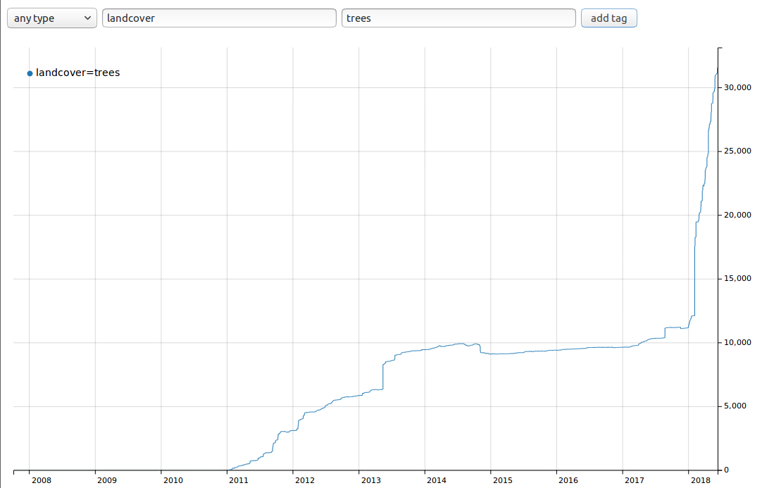
Steep cliffs indicate that large scale bot edits are extremely likely to be large part of usage of landcover=trees. See 2013, 2017, early 2018, entire explosive growth in 2018 looks like either massive adoption or slow moving bot edit.
I will not condemn landcover tag based on this alone, that is why I asked for people interested in this topic to prepare report what are sources of this tag - and how many people are using it.
100k new landcover=trees were added since - is it really work of real mappers or a bot edit? If bot edit - where it is documented?
Note that automated edits not made in accordance to https://wiki.openstreetmap.org/wiki/Automated_Edits_code_of_conduct can be reverted at will, by anybody.
create multipolygons for clearings in forest areas.
This style was deliberately changed in past to encourage tagging tree-covered areas this way.
matkoniecz
on 5 Mar 2019
Despite lack of support in editors, numbers of tagged objects and users are growing.
(1) Can you link me to data confirming that more people add landcover tags than in a past?
(2) Support in at least one major editor is absolute prerequisite. And if as diverse group as JOSM developers, iD developers and Vespucci developer(s?) are considering this tag as a bad idea then I would consider it as a consensus that this tagging is a bad idea.
matkoniecz
on 5 Mar 2019
Some time ago I proposed that the areas covered by trees be rendered for
urban areas, because there are no woods or forest plantations.
El mar., 5 mar. 2019 17:26, Mateusz Konieczny notifications@github.com
escribió:
http://taghistory.raifer.tech/
[image: selection_002]
https://user-images.githubusercontent.com/899988/53835014-bcfa4380-3f8c-11e9-98b5-20104eebb5ed.pngSteep cliffs indicate that large scale bot edits are extremely likely to
be large part of usage of landcover=trees.I will not condemn landcover tag based on this alone, that is why I asked
for people interested in this topic to prepare report what are sources of
this tag - and how many people are using it.create multipolygons for clearings in forest areas.
This style was deliberately changed in past to encourage tagging
tree-covered areas this way.—
You are receiving this because you commented.
Reply to this email directly, view it on GitHub
https://github.com/gravitystorm/openstreetmap-carto/issues/2548#issuecomment-469844223,
or mute the thread
https://github.com/notifications/unsubscribe-auth/AGMdPukLqjqjGmj3kFHw5NNUJrYNIHGTks5vTtL9gaJpZM4LjKpS
.
CarlosBrys
on 5 Mar 2019
Support in at least one major editor is absolute prerequisite.
According to who? I've seen plenty of instances where something gets rendered here and then is supported by a major editor because of it. So it goes both ways.
will not condemn landcover tag based on this alone, that is why I asked for people interested in this topic to prepare report what are sources of this tag - and how many people are using it.
I fully agree with you on landcover=trees. You shouldn't discount the whole landcover tagging range just because it though. Going by the tagging history Landcover=grass doesn't seem to have that problem and rendering it would solve a lot of miss-tagging issues IMHO. So I think its worth considering on its own.
Maybe trees should be considered eventually also though despite the mass import in 2018. Once there's enough time for things with it to be cleaned up if need be. Its not like the massively horrible TIGER road, NHD stream, or farmland imports in America stopped those things from being rendered (or that talking about them in the proper channels first did any good at making them less crap). In other words, you shouldn't leave the good intentioned mappers of these tags out to dry because of a few bad ones. Landcover=trees seems to have had pretty normal usage before the import in 2018 also.
 Adamant36
on 6 Mar 2019
Adamant36
on 6 Mar 2019
Requesting tool change first will be seen as attempt from the tool to infuence development. Tagging discussions and forums show demand and use cases; not being rendered is the main hurdle. Usage is growing and accelerating despite not being rendered and not being supported by tools. Taginfo says enough. Many renderings have changed for much less demand.
pelderson
on 6 Mar 2019
Usage is growing and accelerating despite not being rendered and not being supported by tools. Taginfo says enough.
I want to repeat https://github.com/gravitystorm/openstreetmap-carto/issues/2548#issuecomment-469685609
- how many new forests/grass areas are mapped with
landcover=*tags? In general botlike edits addinglandcoverto mapped features may easily boost usage count despite lack of real use among mappers. Ratio oflandcovertolandusetag count grows slightly, but it is important to check is it real use or an undiscussed and revertable mechanical edit. I would be able to double or triple usage oflandcover=treesby blindly running pointless bot edit.
- how many mappers are using landcover tags compared to ones using standard tagging?
Raw count is not enough in case where there is 200x times more popular widely supported alternative and there are clear indicators that large part of usage is blindly added by bot edits ( https://github.com/gravitystorm/openstreetmap-carto/issues/2548#issuecomment-469844223 )
Many renderings have changed for much less demand.
Not in cases where there is existing alternative 200x times more popular.
Requesting tool change first will be seen as attempt from the tool to infuence development.
That is exactly how I see this issue - demand to render landcover=* in attempt to push it, despite lack of good reasons to do it.
matkoniecz
on 6 Mar 2019
Its not like the massively horrible TIGER road, NHD stream, or farmland imports in America stopped those things from being rendered
I may be mistaken but TIGER imported roads were never majority of roads tagged worldwide. And certainly tags used by TIGER were not intended to replace tags used previously.
An equivalent would be using highway=motorroad and highway=minor by TIGER and demanding to render it.
Support in at least one major editor is absolute prerequisite.
According to who? I've seen plenty of instances where something gets rendered here and then is supported by a major editor because of it. So it goes both ways.
While I still think that we should not add things not supported by any editor, I will try describing it differently. Maybe "support in any major editor would be a strong hint that it should reconsidered"?
matkoniecz
on 6 Mar 2019
As potential help for people interested in looking at existing data - here is query to show landcover=trees last edited between two specified dates:
[timeout:180];
(
  way[landcover=trees]({{bbox}})(newer:"2018-01-01T00:00:00Z"); -
    way[landcover=trees]({{bbox}})(newer:"2018-06-01T00:00:00Z");
);
out body geom qt;
(
  relation[landcover=trees]({{bbox}})(newer:"2018-01-01T00:00:00Z"); -
    relation[landcover=trees]({{bbox}})(newer:"2018-06-01T00:00:00Z");
);
out body geom qt;
I looked at early 2018 growth and it appears to be coming mostly from Paraguay import.
more than 98% of landcover=trees last edited in first half of 2018 is coming from this import (overpass turbo reports 50MB of 50MB).
I found some traces of documentation at https://wiki.openstreetmap.org/wiki/User:Lucyintheskypy
See http://overpass-turbo.eu/s/GGD https://www.openstreetmap.org/way/591832256 https://www.openstreetmap.org/way/577879309 https://www.openstreetmap.org/way/584241760#map=17/-25.28003/-57.14384 https://www.openstreetmap.org/way/592376923 https://www.openstreetmap.org/way/591832290#map=19/-25.45245/-54.50788
So if that holds for other periods it means that landcover=trees is nearly completely result of importing data.
The same applies for second half of 2018, with 70MB of 70 MB in Paraguay (imported data), with traces elsewhere.
matkoniecz
on 6 Mar 2019
I want to repeat #2548 (comment)
I seem to remember you saying in another issue that imports weren't necessarily an indicator of something shady or necessarily a reason not to render something. So how come it doesn't go for this situation also? Like I said, the tag was already established before the import. So the issue should be the import, which can be reverted now that you know where its coming from, not tag itself. That also only goes for landcover=trees and not landcover=grass. Which doesn't have the import problem.
Raw count is not enough in case where there is 200x times more popular widely supported alternative
Is there a reason landuse=grass and landcover=grass can't be rendered side by side? The landcover tag is clearly different from the landuse tag. I don't necessarily see one replacing the other just because they both have the word "grass" in them or landuse being an "alternative" to landcover.
Not in cases where there is existing alternative 200x times more popular.
Again, its not an "alternative" its just another way to tag things. Landcover and landuse aren't equal tags.
That is exactly how I see this issue - demand to render landcover=* in attempt to push it, despite lack of good reasons to do it.
I don't see anyone here or on the mailing list trying to "push it." All I see is some people saying there's places where it would be useful to use landcover instead of landuse and some other people disagreeing with them. That's not "pushing it" from either side.
I may be mistaken but TIGER imported roads were never majority of roads tagged worldwide. And certainly tags used by TIGER were not intended to replace tags used previously. An equivalent would be using highway=motorroad and highway=minor by TIGER and demanding to render it.
That's true. I don't think landcover was an attempt to replace landuse by the importer though. My guess is they mapped onto things that weren't mapped yet and that was what tag they decided to do it with. There's no extreme downward spike in the use of landuse=forest or natural=wood anywhere to indicate otherwise or that they were replacing anything.
As far as your highway=motorroad example goes, I think its a bad one because it wouldn't have been an established, used tag before TIGER imported it. Whereas, landcover=trees was already being used.
While I still think that we should not add things not supported by any editor, I will try describing it differently. Maybe "support in any major editor would be a strong hint that it should reconsidered"?
Or its an strong hint that know one ever opened an issue with the editors for the tag because they didn't know about until it was rendered. There's still a lot of pretty established tags that don't have preset in iD Editor. Even ones that have been rendered for a while. It doesn't really mean anything. Except know one has opened an issue requesting a preset for it. It doesn't make them bad tags. So I wouldn't read that much into it if I were you.
Adamant36
on 6 Mar 2019
sent from a phone
On 5. Mar 2019, at 15:53, Mateusz Konieczny notifications@github.com wrote:
Though yes, if meaning would really different that would be a good reason to use it.
the reason there is no difference in meaning currently is because the definitions for landuse=forest and natural=wood have been changed to mean the same thing as landcover=trees
dieterdreist
on 6 Mar 2019
I seem to remember you saying in another issue that imports weren't necessarily an indicator of something shady or necessarily a reason not to render something.
Imports are not invalidating tag, but when most of tag usage was added by import it invalidates claim "it has Xk usages, it means that it is used by mappers".
It still can be used by many mappers but it requires more careful analysis. It would be nice to have data how many times mappers added this tag compared to how many times they added usual tagging (checking just "how many mappers created new areas with landcover tags" is not enough as it would also count people who split landcover tagged area in two).
Or some other clever analysis that would answer "is this tag actually used by mappers, except small minority".
Is there a reason landuse=grass and landcover=grass can't be rendered side by side? The landcover tag is clearly different from the landuse tag.
Use and meaning of both tags is exactly the same.
Again, its not an "alternative" its just another way to tag things. Landcover and landuse aren't equal tags.
In popularity? I agree. In use and meaning - exactly the same - if not please, link me to page/documentation/post describing differences. From post on mailing list - nearly all people advocating it that I noticed on mailing lists want to replace landuse=forest and natural=wood with it. From quick check - in January 2015 it was considered obvious that it is for tree covered areas (see #1242 "As the new symbols are an overlay, they show even if there is another landcover within the forest." was considered noncotroversial and was added to encourage better tagging of tree covered area)
I don't see anyone here or on the mailing list trying to "push it."
See, typical in my experience, post on mailing list https://lists.openstreetmap.org/pipermail/tagging/2019-March/043405.html that triggered posting of https://github.com/gravitystorm/openstreetmap-carto/issues/2548#issuecomment-469685609
Landcover now has about 170 000 usage count.
Still growing rapidly despite not yet being rendered on OSM Carto.
I would say that is enough reason to start renderin landcover on OSM Carto
and other renderings.
And it is exactly the argument that is invalidated by fact that large part of this tag usage is from a single import.
To people interested in rendering landcover tags - following information would be useful:
how
landcover=grassandlandcover=treesis supported in iD, JOSM, Vespucci and other editors? Support in editors is certainly the first step before supporting in rendering tags duplicating existing ones that are far more popular.how many new forests/grass areas are mapped by humans with
landcover=*tags? In general botlike edits addinglandcoverto mapped features may easily boost usage count despite lack of real use among mappers. Ratio oflandcovertolandusetag count grows slightly, but it is important to check is it real use or an undiscussed and revertable mechanical edit. I would be able to double or triple usage oflandcover=treesby blindly running pointless bot edit and currently about half (96k elements) oflandcover=treesdata comes from a single import in Paraguay, what is the source of remaining half? How many were added by human edits?how many mappers are using landcover tags compared to ones using standard tagging?
matkoniecz
on 6 Mar 2019
mports are not invalidating tag, but when most of tag usage was added by import it invalidates claim "it has Xk usages, it means that it is used by mappers".
I guess it comes down to what your definition of "most" is. I don't think 2/3 is "most." Maybe if it was like 8 of 10 objects or something, but were talking about tens of thousands here. Whoever legitimately added the 10 thousand before the import shouldn't get the shaft because some were imported later. Especially since the import is from a single user and can be easily reverted if need be. I'm sure @woodpeck would be willing to look into it and deal with it if need be. The better thing to do is to revert the bad import and go from there then to just say its not worth rendering though.
Use and meaning of both tags is exactly the same.
See @dieterdreist's comment above yours. I think they have the same meaning at this point because of editors on the wiki, not because the tags are actually the same. I could be wrong though.
From post on mailing list - nearly all people advocating it that I noticed on mailing lists want to replace landuse=forest and natural=wood with it.
I didn't see anything on the mailing list about replacing those tags. No one said "render landcover=trees and stop rendering landuse=forest." All the original poster said was "start renderin landcover on OSM Carto and other renderings." Nowhere does that imply the other tags shouldn't be rendered anymore.
In use and meaning - exactly the same - if not please, link me to page/documentation/post describing differences.
Like the original posters example, landcover=grass can be used for small grassy areas in apartment complexes (which currently get miss-tagged as leisure=park) because its not a landuse. Whereas, things like grassy areas next to highway can be tagged as landuse=grass, because its a specific landuse area set aside for grass (a lot of which miss-tagged currently as leisure=garden). Not only would it help avoid landuse being mapped on top of landuse (which is wrong my opinion), it might also help with the miss-tagging. We clearly need a good alternative to the current tagging scheme and I think landcover is it. I'm pretty tired of seeing everything green miss-tagged as a park or a garden.
See, typical in my experience, post on mailing list
I don't see anything pushy in that message. Its just someone stating their opinion why landcover should be rendered and attempting to have more of a conversation about it. People are allowed to discuss things. For it to be pushy in IMHO the user would have employed tactics similar to the ones used by RTFM to push the motorcycle tags. I don't see them or anyone in the discussion doing that though.
how many mappers are using landcover tags compared to ones using standard tagging?
Ones rendered and widely supported. Whereas the other isn't. People aren't going to map a tag they don't know about and isn't supported in any editors more then one they do and is. Plus landuse has been around forever, but landcover is fairly new. So its nonsensical to compare them. Its like comparing apples and oranges (especially since the meaning of the tags are different). I'm not sure why your stuck on comparing them as if they are 1/1, 100% equal tags when they clearly aren't. Otherwise, why did @dieterdreist even propose landcover in the first place? I Don't think he would have wasted his time if they were the same tags and didn't have clear differences. @polarbearing opened this issue before the import also and there was clearly a difference for him between them back then. The original definition of a tag or its usefulness doesn't change just because of an import.
Adamant36
on 6 Mar 2019
nearly all people advocating it that I noticed on mailing lists want to replace landuse=forest
and natural=wood with it.
Not to replace all landuse=forest and natural=wood, but to tag landcover over another landuse. E.g. patches of greenery over a landuse=residential. There is no rush. It is logical that many small "forests" in residential areas will gradually be retagged as landcover, and new patches will be tagged with landcover=* directly.
pelderson
on 6 Mar 2019
There were such proposals. Not in this thread on ml, but in one of previous ones, with
landcover=treesrendering support as the first step toward dropping rendering and deprecating oflanduse=forest
I know of one user who advocates landuse=forestry instead of landuse=forest. This idea did not get much support. Nobody advocates mass replacement of installed base. Just rendering landcover=* where landuse is not know or over a different landuse. So mappers don't have to define tiny forests or scrub areas within a residential or industrial area.
pelderson
on 6 Mar 2019
"Nobody advocates mass replacement of installed base."
Exactly. The original proposal didn't. That should be the important thing. Not that one person, who's idea wasn't supported by anyone else, advocated for it years later.
"So mappers don't have to define tiny forests or scrub areas within a residential or industrial area.'
That's the same usage I've seen other people say the tag would be useful for to. I'm not sure why matkoniecz is acting like there isn't a use case for it when he's been involved in all the conversations where people said how it will be used differently then landuse.
"In that case people interested in promoting landcover taggings should do that (please, check whatever landcover issue is already opened and follow rules of their issue trackers - note that demanding to do something is unlikely to be effective way of achieving things)."
Know one is demanding anything. We are just saying why what your saying is wrong. Last time I checked we aren't entitled to just nod our heads and agree with everything you say like its the last word on things. We can say why we think something should be rendered also. Its not "pushing" or "demanding" anything to do so. I don't appreciate the insinuation that we are.
There's also no mandate that other software should support a tag before this style does either. Otherwise a lot of stuff would have never been rendered. If you want to open an issue to get it put in the guidelines feel free. Until then stop acting like it an established, set in stone rule when its not. It might discourage people from opening issues for things (I know the general animosity toward discussing things already does. That's more then enough).
Adamant36
on 6 Mar 2019
Yes the discussion about landcover has always been push-back by the accusation "there is a landuse tag equivalent that is much more used". But the idea of landcover tag itself is to remove ambiguity in the current tagging with the landuse tag itself. At the moment, the landuse=forest both tag landuse AND landcover, while we just want to split the two : so we could tag a forest as landuse=forest, but also (as others already explained) a patch of trees in residential area as "landcover=trees". They really can co-exist as they don't have the same meaning - landuse should not be used for landcover usage, and if we support widely the landcover alternative, the landuse tag could only benefit from that as it would just become less ambiguous (one less definition/usage in this tag that already combine a lot of different things). Data user would be rather happy to have a landuse tag that only means "landuse" and not "landcover" too ! :-)
The same apply for landcover=grass, it is only there to tag explicitly a landcover, not to replace landuse=grass if there are places it is logical.
Also, most normal users that i see, only map things that are rendered (even if we explain them that a better tag exist and should be used instead, they prefer the widely used landuse tag as it is rendered). So if we add the rendering for these landcover alternative, it could be used by these people as well and gain more popularity.
But for the technical parts, is there really a problem to just add the exact same rendering for landcover=trees than the one for landuse=forest ?
 lgiard
on 6 Mar 2019
lgiard
on 6 Mar 2019
There is a four-sided hockeystick standstill at the moment, players being tagging-definers / mappers / renderers / mapping tools. Usage is growing and accelerating despite this standstill, even when not counting automated tagging. The main request is having the option to tag / map objects for which landuse is used while it is in fact an area of landcover within a different landuse, mainly residential and industrial; or where the use of the land is unknown but the mapper can see what's on it.
The main obstacle is lack of rendering on the main platform. A lot of doubletagging is going on because of that: "it is landcover so I'll tag that, but it doesn't render so I'll keep or add landuse/natural as well".
I really think it is time to break the standstill, not wait for the other players to move. The mappers have moved, who follows?
pelderson
on 6 Mar 2019
I am inclined to lock discussion here because participants keep doing exactly what they have been asked not to in https://github.com/gravitystorm/openstreetmap-carto/issues/2548#issuecomment-398790403, i.e. arguing what is the best way to tag certain things and key semantics.
So for the last time: This is not the place to discuss tagging or key semantics. If the discussion continues to circle around these topics there is no point in having it here and bothering everyone subscribed to this project with it. @matkoniecz was so nice to ask in https://github.com/gravitystorm/openstreetmap-carto/issues/2548#issuecomment-469685609 for specific information that might shed a positive light on the tags discussed here. If you can provide solid information on those questions please do so. But do so without derailing the discussion by drifting into lobbying for certain tagging ideas. As i explained in https://github.com/gravitystorm/openstreetmap-carto/issues/2548#issuecomment-395591678 the politicization of the matter is not in support for rendering the tags discussed here.
imagico
on 6 Mar 2019
Usage is growing and accelerating despite this standstill, even when not counting automated tagging.
[citation needed] How you know that? Remember that taginfo tag statistics include bot edits, so better analysis is needed to exclude automated edits.
The mappers have moved
[citation needed] How you know that?
But for the technical parts, is there really a problem to just add the exact same rendering for landcover=trees than the one for landuse=forest ?
No, that part is easy (10 minutes of coding, 2 hours of testing, about 8 hours for PR discussion, 4 hours for closing reports asking for reverting it). The blocker is deciding that landcover should be rendered.
Also, most normal users that i see, only map things that are rendered (even if we explain them that a better tag exist and should be used instead, they prefer the widely used landuse tag as it is rendered).
The problem is not that landcover is used by minority. The problem is that landcover is used by extremely tiny minority and there is a strong opposition to it.
So if we add the rendering for these landcover alternative, it could be used by these people as well and gain more popularity.
I understand that it would strongly push forward this highly controversial tag. That is exactly why I am unwilling to make this style the first place supporting it - before any support in editors.
There's also no mandate that other software should support a tag before this style does either.
In case of controversial tags like landcover=* - I am against using this map style as method of forcing them on a community. Especially in cases where controversial tags are used by a tiny minority.
I am not unrealistic and I am not going to expect that it would be in wide use for example by iD mappers.
But my claim is that nearly nobody is using this tag among community of mappers, even among people using editors with direct access to tags as primary editing method (unlike iD) and with support of custom presets (JOSM, Vespucci).
I can be easily convinced by data showing that reality is different and that landcover=* tag is in some use by mappers. For example "more than 1% of new forested areas added by human mappers have landcover tags" claim that can be reproduced would be a very good argument.
But without some evidence that this tag is used by some noticeable part of community of mappers starting to render it would be unfair for OSM community. I do not think that this map style should be used for forcing new tagging schemes.
Note that given large bot edits (I easily found one import in Paraguay that added 96k landcover=trees - over half of all landcover tags) raw usage count from taginfo is not evidence that this tag is widely used by human mappers.
Overall my claims is that
landcovertags are highly controversiallandcovertags are widely discussedlandcovertags are without support of community of OSM mapperslandcovertags are without support of community of OSM mappers discussing about tagginglandcovertags are without support from any major editorlandcovertags are hundreds times less popular than typically used alternativeslandcovertags are mostly added by bot edits (confirmed, single import in Paraguay added 96k of 170k present tags, source of remaining 74k objects requires further research)landcovertags are not used on regular basic by vast majority of mappers (unverified - I would be happy if someone would be able to check this)landcovertags are liked and wanted by small fraction of mappers (this is my guess and it may be wrong, but if someone thinks otherwise it should be fairly easy to disprove - either move https://wiki.openstreetmap.org/wiki/Proposed_features/landcover to vote stage or create a new proposal for landcover and held vote for it - I expect it to result in a clear rejection, though note that this map style is not obligated to render all tags that won votes and to not render unapproved tags)- EDIT, added:
landcovertag is an attempt to replace and deprecate extremely widely used tags - see https://wiki.openstreetmap.org/wiki/Proposed_features/landcover#New_tags_and_deprecated_tags (and yes, it was present from start - see https://wiki.openstreetmap.org/w/index.php?title=Proposed_features/landcover&oldid=590578#This_proposal_deprecates ). Making first step toward deprecating tags used millions of times should be done only if there is a consensus to do that. - EDIT:
landcover=treessupport was refused for iD as duplicate ofnatural=woodandlanduse=foresthttps://github.com/openstreetmap/iD/issues/4272
- EDIT: landcover=trees usage growth is very small if bot edits are ignored (certainly true in 2018, in general depends a bit on what is considered "very small" - I am comparing with landuse=forest and natural=wood)
To people interested in rendering landcover tags - following information would be useful:
how
landcover=grassandlandcover=treesis supported in iD, JOSM, Vespucci and other editors? If not - is it because it was never requested or is it something that was rejected? What was the reason for rejection? Support in editors is certainly the first step before supporting in rendering, especially for controversial tags duplicating existing ones that are far more popular.how many new forests/grass areas are mapped by humans with
landcover=*tags? In general botlike edits addinglandcoverto mapped features may easily boost usage count despite lack of real use among mappers. Ratio oflandcovertolandusetag count grows slightly, but it is important to check is it real use or an undiscussed and revertable mechanical edit. I would be able to double or triple usage oflandcover=treesby blindly running pointless bot edit and currently more than half (96k elements) oflandcovertags comes from a single import in Paraguay, what is the source of remaining ones? How many were added by human edits?how many mappers are using landcover tags compared to ones using standard tagging?
matkoniecz
on 6 Mar 2019
participants keep doing exactly what they have been asked not to in #2548 (comment), i.e. arguing what is the best way to tag certain things and key semantics.
Strawman. I'm mainly pointing out that landcover tag usage is growing rapidly despite not being rendered by the main rendering platform. I can't see why the vehement opposition to rendering this harmless (non-destructive) tagging addition which is already widely used.
I'm sure the issue will keep coming back, it's a reasonable enough request.
pelderson
on 6 Mar 2019
landcover tags are highly controversial
Not the basic landcover=[trees|grass] tag.
landcover tags are widely discussed
That's good. Many rendered tags are widely discussed.
landcover tags are without support of community of OSM mappers
There is massive support for the basic tag itself, but the lack of rendering is seen as a problem. Discussions focussed on all kinds of ideas and schemes around meaning and implications of landuse/natural/landcover and different value systems. This has little to do with rendering landcover=grass as grass.
landcover tags are without support of community of OSM mappers discussing about tagging
Same as above. Ample support for the basic tags landcover=grass and landcover=trees if they are likely to be rendered.
landcover tags are without support from any major editor
Editor support is not essential and will follow once the main renderer announces.
landcover tags are hundreds times less popular than typically used alternatives
Installed base is very large and landcover tags are not rendered. Still the usage is growing.
landcover tags are mostly added by bot edits (confirmed, single import in Paraguay added 96k of 170k present tags, source of remaining 74k objects requires further research)
If the import is ok, it's regular usage. The usage counts 6K users. Growth curve is gradual apart from a few steep climbs.
landcover tags are not used on regular basic by vast majority of mappers
landcover tags are liked and wanted by small fraction of mappers
Not being rendered or supported by editors and tools guarantees that the majority of mappers do not use them. Still the usage grows, both in objects and in users.
...this map style is not obligated to render all tags that won votes and to not render unapproved tags
It's a choice. Got that.
pelderson
on 6 Mar 2019
The landcover tag has never been controversial, the controversy is always about the landuse tag and people hijacking the landcover discussion to discuss about landuse=forest polemic.
The landcover=trees is straightforward, people uses this tag for "area with trees" (where other landuse or natural=wood doesn't apply) and request to be rendered exactly the same way the natural=wood or landuse=forest tag (if you want to use it to replace forest itself, it should be discussed on the mailing list). That's all, what's so problematic with that simple request ? It is widely used (without counting import), and slowly but surely growing (the only problem is double tagging at the moment so that the polygon get rendered).
We don't ask to change the whole tagging scheme here, just to render two tag with at least 10k+ uses (for landcover=trees & landcover=grass), that get legitimate use for their "original purpose" i.e. as a simple landcover feature.
To summarize the problem we face : the renderer (here) demand usage by the editors first; the editors demand the rendering first and the tagging mailing list demand the other two. So how do we advance ? That's really a question i'm asking, if you want us to lead the discussion elsewhere (i completely understand your point of view), how can we get support from you (renderer team) or the editor team ? What's are the objectives things that need to be achieve before a rendering can be applied ?
lgiard
on 6 Mar 2019
I am inclined to lock discussion here because participants keep doing exactly what they have been asked not to in #2548 (comment), i.e. arguing what is the best way to tag certain things and key semantics.
To quote @matkoniecz "Use and meaning of both tags is exactly the same." Telling him he's wrong about that and how isn't arguing semantics or what the best way to tag something is. Its saying the tags are different. Which they are.
Go ahead and lock the issue if you want though. It will be a nice little self fulfilling prophecy that you and @matkoniecz can point at to prove its a controversial subject, when your the ones that are making it that way.
landcover tags are highly controversial
Their controversial because you keep ignoring the counter arguments and saying they are. All the conversation I've seen it was pretty mild and there was a good balance of people for and against it. Know where is anyone outright against the tag. Most of the complaints are just about the lack of usage. That doesn't make the tag controversial though. Your making up the controversy to deflect from counter evidence and as a way to more easily dismiss other people's opinions that disagree with you.
landcover tags are without support of community of OSM mappers
There was plenty of people in the mailing list discussion that said they use it. There's also people here that support it, but might not use it per say. Personally I don't because its not rendered, but 100% would and let other people know about it if it was. I've had lots of conversations with mappers who said they would use it if it was rendered also.
landcover tags are without support from any major editor
The only reason iD Editor was against it is because of the low numbers compared to the other tags. It had nothing to do with the tag itself though. JOSM also has a plugin for it. So its supported, just not built in.
landcover tags are hundreds times less popular than typically used alternatives
Again, they aren't "alternatives." They are different tags. Repeating it over and over doesn't make it true. "Popularity" doesn't have anything to do with it either.
landcover tags are hundreds times less popular than typically used alternatives.
again, its not about the tag be popular or not in respect to another "similar" tag. Tags have different usage numbers. That's life. They are different tags though.
landcover tags are mostly added by bot edits (confirmed, single import in Paraguay added 96k of 170k present tags, source of remaining 74k objects requires further research)
Like I said above, just solve the problem by having @woodpeck revert the imports. That's what's done in every other situation. There's nothing unique about it here.
landcover tags are not used on regular basic by vast majority of mappers
Because they aren't rendered and people don't know they exist. Its another case of self fulfilling prophecy. You don't render something, so its not used, so you continue to justify it not being rendered because its not used.
landcover tags are liked and wanted by small fraction of mappers (this is my guess and it may be wrong
It is wrong. Plenty of people on the mailing list said they use it and it had a lot of uses before the import. You were involved in all those discussions. You shouldn't act like you weren't. I also used your OverPassTurbo query to check America and none of the uses I found there were imports. So Your obviously ignoring the counter evidence that people use it to push your narrative that its all bot edits. They just don't use it as much as the "established" tags. That doesn't mean its not being used though or that everyone is against it like your claiming.
either move https://wiki.openstreetmap.org/wiki/Proposed_features/landcover to vote stage or create a new proposal for landcover and held vote for it - I expect it to result in a clear rejection
It probably would be rejected at this point since its 7 years later and a bunch of people, mostly you, have been lying this whole time about how the tags are meant to replace the established ones when known, including @dieterdreist in this issue, said they were.
though note that this map style is not obligated to render all tags that won votes and to not render unapproved tags
Yeah exactly, your going to refuse it being rendered either way for whatever reason. If it wins a vote or not. Your clearly the only one pushing the agenda here.
especially for controversial tags duplicating existing ones that are far more popular. especially for controversial tags duplicating existing ones that are far more popular.
Again, its not duplicating existing tags. Your obviously being intentionally misleading about it at this point. And again, its only controversial because your making it that way and keep saying it is.
how many new forests/grass areas are mapped by humans with landcover=* tags? In general botlike edits adding landcover to mapped features may easily boost usage count despite lack of real use among mappers.
Again, there was 10,000 edits by actual people before the import and plenty of since then have said they either currently use it or will if its rendered. Keep using the "bot" straw man though.
landcover tags comes from a single import in Paraguay, what is the source of remaining ones? How many were added by human edits?
Because you don't know where they came from, they must be nefarious right? Almost every time I've talked to you about anything, it was because you thought someone was doing something nefarious. 99% of there wasn't anything bad going on though. There probably isn't in this situation either. If there is some bot edits though, just have them reverted. Tags are imported and reverted all the time. I'm not sure why its an issue. I know plenty of places where the "alternatives" to this tag have been imported without discussion or anything. Why don't you have a conniption and remove rendering for them because of it?
Strawman. I'm mainly pointing out that landcover tag usage is growing rapidly despite not being rendered by the main rendering platform. I can't see why the vehement opposition to rendering this harmless (non-destructive) tagging addition which is already widely used.
Straw men is all they have. Nothing @matkoniecz has said is based in any facts. He obviously doesn't care though. There's zero legitimate reason to not render the tags. They have rendered plenty of other tags that were both more controversial (especially since this controversy is completely fabricated) and had more serious issues. Including massive imports. @matkoniecz himself was perfectly fine with rendering something a while back that was like 50% imports.
I'm sure the issue will keep coming back, it's a reasonable enough request.
It totally will. There's zero wrong with the tag and there's clearly benefit to rendering it. Otherwise @dieterdreist wouldn't have proposed it. I bet he knows way more about this stuff then @matkoniecz does.
Adamant36
on 6 Mar 2019
The landcover tag has never been controversial, the controversy is always about the landuse tag and people hijacking the landcover discussion to discuss about landuse=forest polemic.
Exactly. Its not a controversy in the first place. Except when certain people make it one by going off landuse=forest and the other similar tags.
how can we get support from you (renderer team) or the editor team ? What's are the objectives things that need to be achieve before a rendering can be applied ?
You probably can't. @matkoniecz clearly doesn't want it rendered. Which is why he said even having an improved vote might not be enough (after he said to have it voted on). He intentionally set the bar to "editors have to support it first" because he knows its not going to happen unless it gets wider usage, which it won't unless it gets rendered, and the cycle continues. But it gives enough to justify not rendering it.
P.S. I see your thumbs down SomeoneElseOSM. I'm aware I'm probably being a little backhanded. So I'm fine with it. Feel free to leave a comment along with the thumbs down if you want. I've said all I need to about the subject.
Adamant36
on 6 Mar 2019
@lgiard
the editors demand the rendering first
Can you link me to such requests in JOSM, Vespucci and iD? As far as I know JOSM, Vespucci and iD are happy to add support for features not rendered anywhere, barrier is typically much lower than for rendering in this style (for multiple reasons). And from just found iD ticket - rendering is not even mentioned.
It would answer one of questions that was asked
how landcover=grass and landcover=trees is supported in iD, JOSM, Vespucci and other editors? If not - is it because it was never requested or is it something that was rejected? What was the reason for rejection? Support in editors is certainly the first step before supporting in rendering, especially for controversial tags duplicating existing ones that are far more popular.
matkoniecz
on 6 Mar 2019
@Adamant36
It probably would be rejected at this point since its 7 years later and a bunch of people, mostly you, have been lying this whole time about how the tags are meant to replace the established ones
First of all, thanks for confirming my suspicion that landcover tag is rather disliked by general OSM community.
On topic of deprecation - see https://wiki.openstreetmap.org/wiki/Proposed_features/landcover with
The 'landuse=grass' tag should be deprecated with landcover=grass taking its place.
See also https://wiki.openstreetmap.org/wiki/Proposed_features/landcover#New_tags_and_deprecated_tags - section titled "New tags and deprecated tags" that proposes to deprecate multiple tags.
Is there a better documentation of landcover proposal?
BTW, note that comments like "a bunch of people, mostly you, have been lying this whole time" is against basic and obvious rules of not being rude. It is also against our code of conduct - see https://github.com/gravitystorm/openstreetmap-carto/blob/master/CODE_OF_CONDUCT.md Please avoid this kind of comments. Even if such comments would be correctly describing situation it still would be preferable to mention it in a less aggressive way.
matkoniecz
on 6 Mar 2019
First of all, thanks for confirming my suspicion that landcover tag is rather disliked by general OSM community.
I don't think that's what I did. People can be for tag because its a good tag, but against a certain aspect of its implementation due to disinformation. As I've said already, I haven't seen anyone that's outright against it.
On topic of deprecation - see https://wiki.openstreetmap.org/wiki/Proposed_features/landcover with
In response see https://github.com/gravitystorm/openstreetmap-carto/issues/2548#issuecomment-348537988 bullet point 4. The proposal page has been edited a lot by a lot of different people since it was created. So who knows when the part you cited was added to it or if it was there originally. It doesn't seem to be current opinion of the person who created the proposal at least. Ultimately, anyone can edit a wiki page and put whatever they want on it (that sentence could just as easily be removed). The original intent of the tag should be the important thing.
See also https://wiki.openstreetmap.org/wiki/Proposed_features/landcover#New_tags_and_deprecated_tags - section titled "New tags and deprecated tags" that proposes to deprecate multiple tags.
See the first paragraph on the top. "The 'landuse=grass' tag should be deprecated with landcover=grass taking its place." Notice it says it "should" be. Not "will be" or "is being." Its just a recommendation. Again, did @dieterdreist put it there? And if so when? If it was before his comment here in 2017 he's clearly changed his mind. Maybe he just never got around to updating the page to reflect it. It shouldn't matter though. Since its just a recommendation. Personally, I don't see anything wrong with landuse=grass eventually being phased out some day if that's the tagging usage goes, but know one is suggesting it.
BTW, note that comments like "a bunch of people, mostly you, have been lying this whole time" is against basic and obvious rules of not being rude.
Yeah, I know. Your always willing to take an opportunity to chide me about the rules but you never do when its someone violating them to me. If your going to keep making exceptions, keep it to yourself. I'm sick of hearing it.
Even if such comments would be correctly describing situation it still would be preferable to mention it in a less aggressive way.
I can agree with that. I'll try to find a less aggressive way to accuse you of lying next time ;)
Btw, thanks for providing sources this time to back up what your saying and refute points. It helps a lot and gives more room for the problems you have with the tag to be addressed.
Adamant36
on 6 Mar 2019
So who knows when the part you cited was added to it or if it was there originally
Everybody able to check page history - see https://wiki.openstreetmap.org/w/index.php?title=Proposed_features/landcover&action=history
See also latest version edited solely by the author - https://wiki.openstreetmap.org/w/index.php?title=Proposed_features/landcover&oldid=590578#This_proposal_deprecates
And, yes, landcover proposal wanted to deprecate multiple tags from the very beginning.
matkoniecz
on 6 Mar 2019
And, yes, landcover proposal wanted to deprecate multiple tags from the very beginning.
Hhhmmm, well maybe @dieterdreist can comment on the incongruity then. I still haven't seen anyone advocate for it and it sounds more like a recommendation where it is mentioned then a mandate. Tags do replace other outdated tags though and sometimes both are rendered in the meantime.
There has been rendering of both power=substation and power=station for a while. There's also a PR currently in the works to rendering competing healthcare tags, amenity=hospital and healthcare=hospital etc if I remember correctly, which seems to have support. So its not un heard of to render two similar, competing or not competing, tags at the same time.
Adamant36
on 6 Mar 2019
Can you link me to such requests in JOSM, Vespucci and iD? As far as I know JOSM, Vespucci and iD are happy to add support for features not rendered anywhere, barrier is typically much lower than for rendering in this style (for multiple reasons). And from just found iD ticket - rendering is not even mentioned.
I'm happy to chime in from the iD perspective.. landcover=trees was proposed here: https://github.com/openstreetmap/iD/issues/4272
We decided not to support it because it really doesn't offer anything over the existing tags that are in widespread use. I offered to dual-tag landcover tags with other existing established natural and landuse tags, but people didn't want that.
I wrote:
natural=woodis used, in practice, for all kinds of tree cover, (not just "primeval woodland" - why do people think this?). I see it used pretty frequently for small groups of trees even in urban areas.
landuse=forestis also used, in practice, for all kinds of tree cover, but preferring towards places where the trees are managed by forestry. I just don't see how the newlandcovertags solve any problem not already handled by thenaturaltags.
So it's 2019 and the landcover tagspace is pretty much a failed experiment. I'd love for people to stop pretending otherwise. Also it would be great if maintainers of the wiki would make this clear, so people don't think that the tags have any chance of being supported anywhere.
This is ok! Sometimes tags fail because they don't fulfill an actual need, or because the cost of switching tags doesn't offer enough benefit over the existing tags. The important thing is to not read to literally into the words that we use for the tags. (lots of building are not buildings, lots of highway are not highways, and yes, lots of landuse are not landuse. deal with it!)
 bhousel
on 6 Mar 2019
bhousel
on 6 Mar 2019
Again, landcover tagging is growing despite not being rendered by OSM Carto
and not being supported bij Id.
Also, I don't think your adding your own negative arguments to text of the
original proposal helps. Should we all edit our arguments into that?
I would rather create a new proposal documenting the current use of the
landcover tag without argumentation, just basic info how it's used. No big
schemes or plans.
Fr gr Peter Elderson
Op wo 6 mrt. 2019 om 17:17 schreef Bryan Housel notifications@github.com:
Can you link me to such requests in JOSM, Vespucci and iD
https://github.com/openstreetmap/iD/issues/4272? As far as I know JOSM,
Vespucci and iD are happy to add support for features not rendered
anywhere, barrier is typically much lower than for rendering in this style
(for multiple reasons). And from just found iD ticket - rendering is not
even mentioned.I'm happy to chime in from the iD perspective.. landcover=trees was
proposed here: openstreetmap/iD#4272
https://github.com/openstreetmap/iD/issues/4272We decided not to support it because it really doesn't offer anything over
the existing tags that are in widespread use. I offered to dual-tag
landcover tags with other existing established natural and landuse tags,
but people didn't want that.I wrote:
natural=wood is used, in practice, for all kinds of tree cover, (not just
"primeval woodland" - why do people think this?). I see it used pretty
frequently for small groups of trees even in urban areas.
landuse=forest is also used, in practice, for all kinds of tree cover,
but preferring towards places where the trees are managed by forestry. I
just don't see how the new landcover tags solve any problem not already
handled by the natural tags.So it's 2019 and the landcover tagspace is pretty much a failed
experiment. I'd love for people to stop pretending otherwise. Also it would
be great if maintainers of the wiki would make this clear, so people don't
think that the tags have any chance of being supported anywhere.This is ok! Sometimes tags fail because they don't fulfill an actual need,
or because the cost of switching tags doesn't offer enough benefit over the
existing tags. The important thing is to not read to literally into the
words that we use for the tags. (lots of building are not buildings, lots
of highway are not highways, and yes, lots of landuse are not landuse.
deal with it!)—
You are receiving this because you commented.
Reply to this email directly, view it on GitHub
https://github.com/gravitystorm/openstreetmap-carto/issues/2548#issuecomment-470171213,
or mute the thread
https://github.com/notifications/unsubscribe-auth/AkrTynyvUR1CSUnGOqqW_rFGcSrRoRPCks5vT-oagaJpZM4LjKpS
.
pelderson
on 6 Mar 2019
I'm temporarily locking this because of the unproductive heated discussion and code of conduct violations.
pnorman
on 6 Mar 2019
I've unlocked this. Please remember the code of conduct, in particular,
- Be respectful
- In particular, respect differences of opinion.
- Avoid destructive behavior:
- Derailing: stay on topic; if you want to talk about something else, start a new conversation.
- Unconstructive criticism: don't merely decry the current state of affairs; offer—or at least solicit—suggestions as to how things may be improved.
- Snarking (pithy, unproductive, sniping comments)
- Microaggressions: brief and commonplace verbal, behavioral and environmental indignities that communicate hostile, derogatory or negative slights and insults to a person or group.
pnorman
on 10 Mar 2019
For a more fact based look at things here a few numbers from running through a recent history planet file.
There are 48061 version 1 way/relation features with landcover=trees in the planet history. That is the number of features that were created with a landcover=trees tag, i.e. cases where a mapper mapping a feature originally decided to tag it this way. This includes features deleted later or where the landcover tag has been removed later and does not include features where the landcover tag has been added later. Therefore it is a fairly good measure of active use of a tag by mappers newly mapping things.
Here is the list of user names with more than 100 features created including the number of features created:
    115 Arq%20%Alejandro%20%Hoyos
    118 SandraI
    120 MaiaQ
    121 sapitopintor
    122 altairb
    128 n76
    130 Lorena%20%F
    133 MarcoR
    133 NatBC
    136 Hora
    137 nimapper
    151 Gustavo%20%León%20%Servin
    154 DarkSwan_Import
    167 soledadjv
    173 Dahianna%20%Anonis
    175 MapPYOSMMirtha%20%Burgos
    177 tamaratorres09
    178 eugedelgado
    186 imagic
    197 SergioMartínez
    200 Warin61
    215 Majo%20%Cabral
    236 XGiret
    259 Mónica%20%Godoy
    264 María%20%Malvetti
    274 Guido%20%villalba
    275 María%20%José%20%González%20%Ayala
    297 Emistrac
    307 wvsch
    326 monicakrause
    343 MariaSanabria
    365 _al
    379 VioletaKrissRoa
    388 GiuseppeAmici_IT
    411 etrumap
    423 Pieter%20%-%20%Ede
    424 RodrigoOrjuela
    428 MapPyMara%20%Maravilla
    513 Perry-juancamilo
    570 RAMONML
    584 Christian%20%Ricardo
    743 MapPyOSM%20%-%20%Diego%20%Bernal
    786 SaraMZ
    823 Sara%20%Gonzalez
    830 MapPYOSM%20%Manuela%20%Stanley
    900 MapPy-GabrielaCristaldo
   1068 analiaMO
   1213 verstones
   1249 MapPYOSM%20%Jazmín%20%Sanabria
   1257 katrina%20%lisnichuk
   1410 Cindy%20%Franco
   1428 MapPyOSMDaniel%20%Diaz
   1598 Guillermo%20%Torres
   2871 torpemanzano
   3496 jacqueinsfran
   3672 Stella%20%GBO
   4771 dieterdreist
   5672 dieggovera
I did not check the whole list but all of those with more than 500 features except dieterdreist are part of an organized effort in Paraguay. Most of them have from a few dozen up to a few hundred changesets and stopped mapping about three months ago.
So overall conclusion for me is that there is much less active organic use of the tag by individual mappers using the tag out of their own free choice than the raw numbers from taginfo indicate. I don't know the details of how this project in Paraguay came to choose using landcover=trees but likely this results from misinterpreting the meaning of existing tags. If you remove the numbers resulting from the organized effort in Paraguay adoption of landcover=trees by mappers is hardly higher than of landcover=grass.
So far for the analysis. I hope this provides a better understanding on use of the landcover=trees tag and helps understanding why it is so important to look closely how tags are used, by whom and what guides their decision to do so. I also hope this shows why taginfo numbers and taghistory plots do not typically show the whole story and are rarely a good basis for making rendering decisions here.
imagico
on 10 Mar 2019
The data was loaded for a long time by students of a research project of the Faculty of Architecture and Design of the National University of Asuncion, Paraguay. "MapPy OSM - CIDI FADA UNA. Systematic mapping of Paraguay-Buildings-Vegetation-Water". See: https://www.facebook.com/mappyosm/
The names of the editors correspond to the students of the university of Asunción, Paraguay, who participated in the research project.
The use of the label landcover=trees was discussed at length with the OSM community of Paraguay and Argentina because the research project maps urban trees, and that they are not woods or forest. As a result of the discussion many areas were changed, that had been erroneously mapped as forest plantations in cities.
See the OSM forum: https://forum.openstreetmap.org/viewtopic.php?id=61256
There is no soil management in the squares or the houses of the cities, they are only lands covered with trees, that is why the natural wood or managed forest labels are not applicable in that context.
CarlosBrys
on 10 Mar 2019
So, I counted 57 users there. The thing I'm not clear on is what that means exactly? So 57 people in Paraguay mapped a feature. It doesn't mean their edits weren't legitimate because they were all from the same country or say anything about the merits of rendering the tag or not (most countries/areas outside of three main places in Europe only have a small number of users that tend to congregant toward mapping only a few things. In California its a few kinds of landuse and buildings if your lucky). That doesn't really mean anything to rendering those things though. So while its interesting information, I'm still not sure what to take away from it, except its at least not bot edits as prematurely claimed.
Also I don't think why they did or didn't decide to use the landcover tag over something else is relevant, because A. its not something you can know B. It isn't brought up in any other rendering decision.
Another way to look at it would be to exclude those edits from the decision (although I think they matter to make the argument that it should be rendered, but the repeated false of claim of them being nefarious edits was what caused a lot of the problems). Doing that it has essentially same usage of landcover=grass, high enough numbers to render, and globally spread out organic usage by multiple editors.
Its also lame (I'm not sure what the word is) to say landcover=grass shouldn't be rendered because of bad landcover=tree usage (which there wasn't). A lot of my irritation was that when I brought up landcover=grass it was repeatedly deflected by the, now proven false arguments, against rendering landcover=trees. Which seems purposely obtuse. If you can't considering rendering one key without automatically attaching the conversation to another key that you think is badly mapped, there's zero point in discussing or rendering anything. Almost every tag has usage that is bad, be that from bot edits or none approved keys. You couldn't render anything if that was your metrics. Plus, its just dismissive to repeatedly drone on repeatedly about landcover=trees and bot edits when some one asks repeatedly about a different tag. Last I check this issue is about both. So say landcover=trees turns out to be trash and not rendered, it doesn't mean the issue is done and that we can call it a day. Anymore then because one barrier or shop or whatever icon isn't worth rendering we didn't say to hell with rendering the rest of them. Or because power=plant didn't get rendered we then don't render power=substation. Personally, I could care less about landcover=trees, but I think landcover=grass is extremely needed. I don't see why it can't be rendered even if landcover=trees isn't. They ultimately have nothing to do with each other.
Adamant36
on 10 Mar 2019
@CarlosBrys - As said previously what is the proper tagging of things is off-topic here but since your project seems to be by far the largest user of the tag discussed here i will try to quickly comment on your specific situation. But i don't want this to be used to start a more elaborate discussion on woodland tagging or organized mapping, such would need to be done elsewhere.
I don't speak Spanish so i can't follow in detail the discussion you linked to but you seem to have gotten the wrong impression, possibly due to the wiki not properly documenting the actual meaning of tags (which unfortunately is very common, in particular for the tags this is about - you can blame the key systematics fanatics about it), that neither landuse=forest nor natural=wood can be used for urban tree areas. As you can see in other parts of the world (including South America) this is not a widely accepted interpretation of these tags - urban tree areas are tagged with those in many parts of the world in far larger numbers than what you mapped in Paraguay.
Now you are free to tag things the way you do as long as it is fine with the local community but this style has among other things a responsibility to safeguard the privilege of individual mappers to decide on tags they use as a community of individuals independent of organized projects and their collective influence and to do that we do not give a project like yours that tags a hundred thousand features in a uniform way centrally decided on significantly more weight that to a single hobby mapper mapping maybe a few hundred or thousand features.
Now again - this is just an attempt at me explaining how i think this project should and needs to regard organized mapping projects like yours. This is not an invitation to discuss tagging or the rights and responsibilities of organized mapping projects in OSM here - those topics belong into a different venue.
imagico
on 11 Mar 2019
"key systematics fanatics about it.'
If there's going to be a civil discussion about it, it would be helpful not to refer to people who want to see the tags rendered as "fanatics." Even if they are passionate about it. Or the same could said about the people who are against their rendering, but saying as much leads chastisements of not following the rules and the issue being locked. The contributing guidelines about not name calling etc should apply to you as much as they do to people who aren't moderators.
Adamant36
on 11 Mar 2019
I see, only landcover=trees is discussed. But I'm more interested in landcover=grass. I have one example for it.
A man_made=reservoir_covered + landuse=industrial + landcover=grass It is a industrial land, but the main part in underground and it is covered by grass. I don't think that landuse=grass is correct there.
How this should be rendered? As industrial area or as grass? It is both.
 mkyral
on 11 Mar 2019
mkyral
on 11 Mar 2019
Your example reminds me of the library a few towns over from me that has grass covering the roof for cooling in the summer. Its a pretty big roof. As it is to map the grass it would be landuse=commerical (for the grounds) + building=commercial + landuse=grass (for the grass on the roof). Its pretty convoluted. Using landcover=grass makes a lot more sense.
I'm aware it shouldn't be a conversation about "tagging" but its relevant to counter the people who say they are against rendering because the tags don't have a use.
Adamant36
on 11 Mar 2019
I have written a description of current usage of landcover tags. I think it
covers all the usage so far, including the Paraguay mapping project.
It is not meant to be prescriptive, only descriptive. If this description
was broadly accepted, would that help to decide about rendering? Of course
the same question would be put to mappers and editors.
Key:landcoverTags: landcover=trees & landcover=grassUsage: The landcover
key is used to describe what covers the land. Currently, the most used
values are trees and grass. What is tagged: A landcover tag is used to map
a physical area of (currently) grass or trees in two cases:
- when the human use of the land is not known, e.g. an area of grass
not visibly dedicated to any purpose, or - when landcover differs from the implied landcover of the underlying
landuse, eg a grass clearing within a forest, or patches of trees within an
industrial, residential or military area.
In this context, “underlying landuse” includes other tags which represent
types of landuse such as leisure=park.
Combination of landuse and landcover: Area features can have both landuse
and landcover tags. The landuse indicates what the land is used for; the
landcover indicates what it is covered with.
Where landuse implies a landcover and the above two use cases are not
applicable or foreseen, adding landcover is redundant.
Fr gr Peter Elderson
Op ma 11 mrt. 2019 om 09:02 schreef Marián Kyral notifications@github.com:
I see, only landcover=trees is discussed. But I'm more interested in
landcover=grass. I have one example for it.A man_made=reservoir_covered + landuse=industrial + landcover=grass It is
a industrial land, but the main part in underground and it is covered by
grass. I don't think that landuse=grass is correct there.How this should be rendered? As industrial area or as grass? It is both.
—
You are receiving this because you commented.
Reply to this email directly, view it on GitHub
https://github.com/gravitystorm/openstreetmap-carto/issues/2548#issuecomment-471439714,
or mute the thread
https://github.com/notifications/unsubscribe-auth/AkrTyoc6Rcbs7LcOgPLbg124HsLsZccbks5vVg2egaJpZM4LjKpS
.
pelderson
on 11 Mar 2019
"Combination of landuse and landcover: Area features can have both landuse
and landcover tags."
One of the issues I run into all the time is people tagging an area with multiple landuse tags, which results in laduse_1, landuse_2 etc. Its done way more often then it should be. So if this helps solve that great.
Adamant36
on 11 Mar 2019
Apart from the possibilites for the future? Do you agree with this
description of current usage?
Fr gr Peter Elderson
Op ma 11 mrt. 2019 om 10:40 schreef Adamant36 notifications@github.com:
"Combination of landuse and landcover: Area features can have both landuse
and landcover tags."One of the issues I run into all the time is people tagging an area with
multiple landuse tags, which results in laduse_1, landuse_2 etc. Its done
way more often then it should be. So if this helps solve that great.—
You are receiving this because you commented.
Reply to this email directly, view it on GitHub
https://github.com/gravitystorm/openstreetmap-carto/issues/2548#issuecomment-471469068,
or mute the thread
https://github.com/notifications/unsubscribe-auth/AkrTygi33ZGJacK9wpFFYfkROTp89Lcjks5vViSTgaJpZM4LjKpS
.
pelderson
on 11 Mar 2019
Just want to weigh in (my opinion, no facts presented here):
- From a tagging perspective,
landcoverisn't perfect, but it's better than existinglanduse,natural, etc. cases as it addresses some of the ambiguity of existing tagging and solves situations such as grass within a differentlandusearea. - From a decision making perspective, comparing usage of existing tagging which is widely supported in commonly used editors to a proposed replacement tagging which isn't present in said editors by default is a bit of a waste of time. If any random tag is added to a forest/grass preset in iD the usage of that tag would skyrocket.
- There's a bit of an impasse in that existing tagging has some clear issues (otherwise we wouldn't be having this discussion) and yet it is so widely used that it's almost impossible to change.
Conclusion:
The majority of mappers don't feel strongly enough about the issues with these existing tagging schemes to seek new schemes. However, this doesn't necessarily mean they are opposed to change as long as they can still map features with some form of tag (there's probably a fairly large percentage of mappers who are only interacting with editor presets and not tags themselves).
Tags implemented by editors hold a lot of sway here and I imagine have an even greater impact than an import using a specific scheme ever could.
So personally, it seems like landcover probably shouldn't be rendered at the present time. However, there's a bit of a wider issue in that there's no easy system in the OSM space to deal with issues with widely used tagging schemes. I suspect discussion of issues such as this will continue ad infinitum until such a system is established.
 kymckay
on 11 Mar 2019
kymckay
on 11 Mar 2019
Some facts about the use of landcover in Paraguay and Argentina.
The province of Misiones in Argentina is the last reservoir of the paranaense jungle (see the green spot in South America in satellite view here: -26.692, -54.283) bases its economy on afforestation.
The use of the soil with afforestation and natural forest is very important for the provincial economy. If somebody want to calculate the area of forest implanted using the label landuse=forest or natural=wood, the results would be oversized when incorporating the urban tree mass, which is definitely not a forest plantation.
For this reason, the Paraguayan university project was discussed to use the landcover label and not landuse to map urban trees.
CarlosBrys
on 11 Mar 2019
I think the Paraguay and Argentina project fits nicely to the description I
gave.
Fr gr Peter Elderson
Op ma 11 mrt. 2019 om 13:20 schreef Carlos Brys notifications@github.com:
Some facts about the use of landcover in Paraguay and Argentina.
The province of Misiones in Argentina is the last reservoir of the
paranaense jungle (see the green spot in South America in satellite view
here: -26,692, -54,283) bases its economy on logging. The use of the soil
with afforestation and natural forest is very important for the provincial
economy. If somebody want to calculate the area of forest implanted using
the label landuse=forest or natural=wood, the results would be oversized
when incorporating the urban tree mass, which is definitely not a forest
plantation.
For this reason, the Paraguayan project was discussed to use the landcover
label and not launduse to map urban trees.—
You are receiving this because you commented.
Reply to this email directly, view it on GitHub
https://github.com/gravitystorm/openstreetmap-carto/issues/2548#issuecomment-471516781,
or mute the thread
https://github.com/notifications/unsubscribe-auth/AkrTyglxtQ3vapk9vAPQwPZ5FpwNrP99ks5vVkoEgaJpZM4LjKpS
.
pelderson
on 11 Mar 2019
There's a worldwide effort on MapRoulette to clean up duplicate landuse tags such as landuse_1 and landuse_2. In solving some of these tasks, I've noticed that much of the landuse misuse in question is a legitimate need that could be solved by landcover tagging.
For example, cemetery forests are pretty common in Asia. Currently, there is no good way to tag them, but landuse=cemetery + landcover=trees would solve the issue.
There is a proposal for landuse=cemetery + cemetery=wood, but I think that solutions like this
- are too inflexible
- have an even lower chance of being rendered than
landcover=trees - are semantically hard to understand, because
woodis now a value ofcemetery, even though it would be the primarylandusevalue in any other case.
Just imagining how I'd use landcover if it were supported, I see a lot of opportunity for clearer mapping that would also be more representative of real-world features. I would strongly prefer that scheme, even in areas where no serious issues like cemetery forests occur.
 lukf
on 22 Nov 2019
lukf
on 22 Nov 2019
cemetery forests are pretty common in Asia. Currently, there is no good way to tag them
I would be happy to discuss it on tagging mailing list or some other medium like a telegram / slack / OSM Wiki, but I will not do it here as tagging discussions are offtopic here.
matkoniecz
on 22 Nov 2019
Related issues
 Thorwynn
·
3Comments
Thorwynn
·
3Comments
 manfredbrandl
·
5Comments
manfredbrandl
·
5Comments
 d3netxer
·
4Comments
kocio-pl
·
4Comments
Tomasz-W
·
4Comments
d3netxer
·
4Comments
kocio-pl
·
4Comments
Tomasz-W
·
4Comments
Most helpful comment
@pnorman , you mention 6 points and from my point of view, they speak more in favor of rendering landcover tags than against: