ATM, there are two presets:
- embankment=yes https://github.com/openstreetmap/iD/blob/master/data/presets/presets/embankment.json
- man_made=embankment https://github.com/openstreetmap/iD/blob/master/data/presets/presets/man_made/_embankment.json
The way I read the wiki, the first tag is not a top-level-tag but something added to highways. Source.
Usage
Add embankment=yes to a way that is already tagged with a highway=, railway= or waterway=* tag. When micro-mapping, you can also draw two parallel ways and add man_made=embankment to both.
So, IMO the todo is
- remove presets/embankment.json
- make man_made/_embankment.json searchable (and remove "_" from filename)
- move the translations accordingly
Note: Both presets where added in https://github.com/openstreetmap/iD/commit/9e6eacb6982526b53e5bff407496163f201d9843 but with no special comment about why one is prefered.
 tordans
All 12 comments
It looks like the recommendation was embankment=yes until around 2015-ish?
see diff
iD's embankment presets were added in 2013, which is why they are like that.
(Not all embankments are man_made right?)
 bhousel
on 30 Sep 2018
bhousel
on 30 Sep 2018
Thanks, that explains how this came to be.
I agree with the fact that man_made=embankment kind of excludes natural embankment, but for some reason the wiki page does not talk about this :-/. I also feel like natural=embankment would be the better tag for the embankment=yes-case (corresponding to natural=cliff / Wikipage), but that is only used 18 times.
Usage stats:
embankment=yesis used 146,3760 times but 63.2% of that are on highways, so only 54,212 are stand alone (Taginfo)man_made=embankmentis used 68,1950 times and therefore wins the race just barely
What should be the next step?
Is it helpful to ask on the tagging mailinglist?
Or should both tags be added with description of "embankment (man made)" and "embankment (natural)"?
tordans
on 30 Sep 2018
What should be the next step?
Is it helpful to ask on the tagging mailinglist?
Or should both tags be added with description of "embankment (man made)" and "embankment (natural)"?
Yes ask on the tagging mailing list.. Whatever people decide, they should definitely let the editor and carto developers know.
From reading here,
I guess natural=cliff, man_made=embankment, and barrier=retaining_wall are all similar kinds of things.
bhousel
on 30 Sep 2018
embankment=yes is used 146,3760 times but 63.2% of that are on highways, so only 54,212 are stand alone (Taginfo)
embankment=yes is to note that something is on embankment (road, railway). 63% is with highway=* 22% is with railway=*, 4% with barrier=wall.
Remaining usages are 11%, so at most 16k are standalone. Note that 4k (3%) of all usages is with man_made=embankment (double tagging that is more likely to occur with standalone embankments).
 matkoniecz
on 3 Oct 2018
matkoniecz
on 3 Oct 2018
I guess
natural=cliff,man_made=embankment, andbarrier=retaining_wallare all similar kinds of things.
No, they certainly aren't.
The only common thing is that the direction of the way and the definition of what is the lower side, are the same, that is, the right side of the line looking in the direction of the line should be the lower side.
natural=cliff is for true natural cliffs, like rocky or sandy eroded outcrops along the coast, or other forms of cliffs of generally natural origin.
man_made=embankment is a one sided embankment generally "made by man" (although there is some mis-use for things like river eroded embankment). When people micro tag, they put two man_made=embankment tags on either side of a raised railroad or road.
embankment=yes is a kind of shortcut for the above: it kind of implicity assumes a two sided embankment and is indeed most of the time tagged on a highway=x or railway=x feature, like a raised railroad or a road going over a viaduct. Generally, when micro digitized man_made=embankment are added, it is wise to remove any embankment=yes tag, as it no longer provides useful information (and certainly not visually on the map).
barrier=retaining_wall is a concrete or stone (masonry) wall holding back a sand body / raised level of soil, like when a tunnel is dug, then entrance roads generally have barrier=retaining_wall structures on both side of the tunnel entrance.
 mboeringa
on 15 Oct 2018
mboeringa
on 15 Oct 2018
As to rendering examples (from my personal ArcGIS Renderer for OpenStreetMap):
natural=cliff:
man_made=embankment tagged on way features that aren't highways or railways:
embankment=yes tagged on highway (AFAIK my personal ArcGIS Renderer is currently the only renderer supporting this):
barrier=retaining_wall as, in this case, the reinforced sides of a canal (but retaining walls do not have to be associated with water features)
mboeringa
on 16 Oct 2018
Hi @mboeringa, I see that you invest quite some time in defining the different tags. However, for me, personally, that is not what that issue is about.
The question is at https://github.com/openstreetmap/iD/issues/5344#issue-365147109 – Should a stand alone embarkment be tagged with embankment=yes or man_made=embankment.
And as a follow up question: If the correct way is man_made=embankment, how would one tag a non-man-made embankment? – see https://github.com/openstreetmap/iD/issues/5344#issuecomment-425689053, last line
The current status of this ticket is in my opinion:
- bhousel researched why there might be an issue => its about wiki-changes and timing - https://github.com/openstreetmap/iD/issues/5344#issuecomment-425689053
- We agreed on asking the mailing list at https://github.com/openstreetmap/iD/issues/5344#issuecomment-425754663 which I had no time for, yet
- matkoniecz improved the numbers and thereby stressed IMO, that in fact embankment=yes as stand alone tag is not the right way to go - https://github.com/openstreetmap/iD/issues/5344#issuecomment-426616422
What is your take on those questions above?
Thanks
tordans
on 16 Oct 2018
@tordans
Hi @mboeringa, I see that you invest quite some time in defining the different tags.
My remarks and definitions are largely based on the Wiki and formost real world usage. For anyone having looked a lot at the data as well, you'll likely come to the same conclusions for the majority of cases.
The question is at #5344 (comment) – Should a stand alone embarkment be tagged with
embankment=yesorman_made=embankment.
You should first give an example or show a picture of what you mean with a "stand alone embankment"...
Most cases of two sided embankments (linear raised feature with two sides going down) I can think of, especially when man_made, are called "dikes", and should be tagged as man_made=dyke. The Wiki definition of man_made=dyke is already broad enough to also include oil/fuel spill containment dikes around man_made=storage_tank, e.g. in a harbour:
"An embankment built to restrict the flow of water or other liquids(!)."
https://wiki.openstreetmap.org/wiki/Tag%3Aman_made%3Ddyke
man_made=embankment is not suitable as a replacement, as it is currently used for single sided embankments. You need to add two man_made=embankment lines to visually represent a man_made=dyke, but why would you want to do that? (Well, actually, I know of a few examples here in the Netherlands of people micro tagging dozens of kilometer long dyke structures like that, with two lines of man_made=embankment, IMO a bit senseless...)
And as a follow up question: If the correct way is
man_made=embankment, how would one tag a non-man-made embankment? – see #5344 (comment), last line
Well, there is the proposal page for the natural=river_terrace tag:
https://wiki.openstreetmap.org/wiki/Proposed_features/Tag:natural%3Driver_terrace
Especially the linked Wikipedia page about Fluviual terraces:
https://en.wikipedia.org/wiki/Fluvial_terrace
is what I think many people will currently mistag with either man_made=embankment, or natural=cliff.
Of course, besides the action of water erosion caused by a flowing river, there is at least seismic activity or fold lines that may occassionaly lead to an "embankment" or "terrace" like structure as well, but will usually be covered quite well by natural=cliff or natural=ridge.
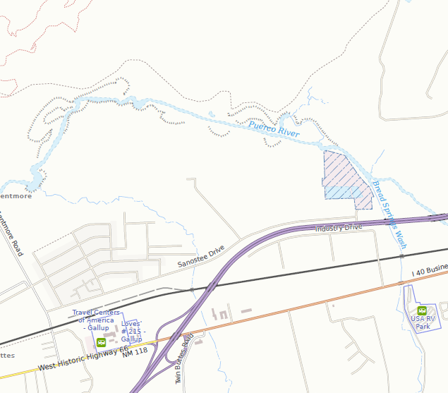
While not official, after some research using Overpass Turbo, I have come to the conclusion that the natural=river_terrace tag, where used, is used appropriately for the majority of cases. As a consequence, I have added rendering support for this tag in my own renderer. Unfortunately, the Wiki page for natural=river_terrace does not yet prescribe the same "right side is low side" rule as for embankments and cliffs. I think this should be amended. As a consequence, some of the symbology is off (my renderer assumes the same right side rule). A nice example is this one of the Puerco River in the western US:
The question is at #5344 (comment) – Should a stand alone embarkment be tagged with
embankment=yesorman_made=embankment.
...
What is your take on those questions above?
Thanks
Back to the original question: I agree that embankment=yes, _when not used on a highway or railway feature_, is less than ideal and should probably be replaced by other tags like man_made=embankment/dyke, or natural=cliff/river_terrace.
So if your question pertains to just embankment=yes tagged ways without any additional highway/railway tag, than yes, I agree this has little value. Using more descriptive and clearer tags like the ones suggested, is more appropriate.
mboeringa
on 16 Oct 2018
Unfortunately, the Wiki page for natural=river_terrace does not yet prescribe the same "right side is low side" rule as for embankments and cliffs. I think this should be amended.
Good idea - I would support edit encouraging such tagging (there is no good reason to not encourage this consistency).
matkoniecz
on 16 Oct 2018
Good idea - I would support edit encouraging such tagging (there is no good reason to not encourage this consistency).
Maybe adding a reference to the natural=river_terrace proposal page from the man_made=embankment and natural=cliff pages would be a good thing as well, to prevent mis-tagging of such natural features as especially man_made=embankment.
Of course, adding support for this proposed tag in openstreetmap-carto would help prevent mis-use as well.
mboeringa
on 16 Oct 2018
Thanks for the great discussion, everyone!
From reading all your responses, it sounds like man_made=embankment is preferred, so I switched the preset to use that tag in c3ac440
I left embankment=yes as a non-searchable preset, so iD will still recognize the legacy tag.
bhousel
on 8 Nov 2018
Is OK with me.
mboeringa
on 8 Nov 2018
Related issues
tordans
·
3Comments
 thibaultmol
·
3Comments
tordans
·
3Comments
thibaultmol
·
3Comments
tordans
·
3Comments
 scaidermern
·
3Comments
scaidermern
·
3Comments
 jidanni
·
3Comments
jidanni
·
3Comments
Most helpful comment
Thanks for the great discussion, everyone!
From reading all your responses, it sounds like
man_made=embankmentis preferred, so I switched the preset to use that tag in c3ac440I left
embankment=yesas a non-searchable preset, so iD will still recognize the legacy tag.