Openstreetmap-carto: Add tags ice_road and winter_road in render
The tags ice_road and winter_road are currently ignored. And the roads look like ordinary.
 RussianFox
All 16 comments
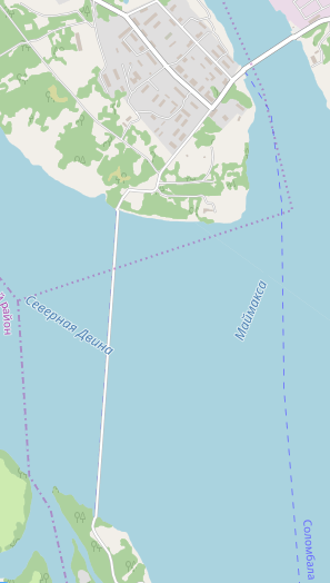
The tag ice_road=yes refers to "Seasonal roads in cold regions that are laid upon frozen water basins and rivers" (wiki), so these roads only exist in the winter season. At other times of year there might be a ferry nearby, as in the example above. This tag has been used 10,000 times, mostly in northern Europe.
Also approved by the same proposal, the tag winter_road=yes is used for roads on land which are "Seasonal roads in northern regions that are functioning during winter, usually impassable in summer." (wiki) Apparently the ground is often a wetland or bog in the summer, so the road is not usable when the ground has thawed - this appears to be common in arctic tundra regions.
(I'm surprised that the proposal to tag these as highway=* was approved - it probably would have been better to avoid using the highway tag for features which are only seasonal, especially for the routes over water, but that appears to be the de facto standard now. )
These two tags are rather specialized for a certain limited area and climate, but I can see how they might be important for these regions. But how can we render them?
It isn't currently possible to have the rendering change by season, so that's a big limitation.
Are there examples of how such roads are represented on paper maps or specialized online maps for the arctic region?
Perhaps ice_road=yes should look similar to a ferry route? And winter_road=yes might be like a highway=track, since that would be it's status in summer at best?
A simple option would be to stop rendering highway= features with winter_road=yes or ice_road=yes, for consistency with the normal meaning of the highway= tags, if we cannot find a specific rendering which works with the other linear features in this style.
 jeisenbe
on 26 Dec 2019
jeisenbe
on 26 Dec 2019
A simple option would be to stop rendering highway= features with winter_road=yes or ice_road=yes
👍 (IMO it would be hard to render them in a way that would still be intuitive and not confuse people, but if they aren't "normal" roads they shouldn't be rendered that way either)
 Adamant36
on 26 Dec 2019
Adamant36
on 26 Dec 2019
We do render intermittent/seasonal rivers, so why not seasonal roads? As @jeisenbe said they are of importance for the region. I like the comparison to ferry lines. Those roads go over water-based features, thus blue and/or dashed might be suitable.
 polarbearing
on 26 Dec 2019
polarbearing
on 26 Dec 2019
We do render intermittent/seasonal rivers, so why not seasonal roads?
Yeah, true.
Adamant36
on 26 Dec 2019
The ice_road features are problematic in the current rendering: during most of the year there is nothing there at all, just open water, or thin ice which cannot be used, but the current rendering suggests some sort of bridge. So for these it would be better not to render them at all than to render them in the current way, though I agree with trying to find a functional special rendering, if someone wants to work on it.
The winter_road features are not quite so bad: it's true that they are not usable in the summer, but one could claim that roads through mountains might be closed in winter due to heavy snow, yet we do not render such roads differently.
Does anyone know if there is a specific tag for a mountain road which is closed all winter? Is it just opening_hours=*?
Also, are there any examples of openstreetmap-based maps which render these features in a special way? It would be good to also request a special rendering for maps which have a different focus, such as Opentopomap or HikeBikeMap.
jeisenbe
on 28 Dec 2019
Does anyone know if there is a specific tag for a mountain road which is closed all winter? Is it just opening_hours=*?
Its not exactly the same, but there's fords mapped as ways.
Adamant36
on 28 Dec 2019
Does anyone know if there is a specific tag for a mountain road which is closed all winter? Is it just opening_hours=*?
Opening hours for this one i know:
https://www.openstreetmap.org/way/25935934#map=13/47.1094/12.8305
 HolgerJeromin
on 28 Dec 2019
HolgerJeromin
on 28 Dec 2019
We have access, want surface and now seasonal opening. Hard to render all. :-(
HolgerJeromin
on 28 Dec 2019
@RussianFox - could you provide an example of how these features are rendered on paper maps or digital maps?
jeisenbe
on 9 Jan 2020
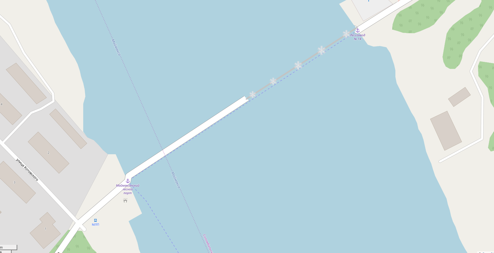
No, but i have some ideas.

RussianFox
on 9 Jan 2020
Looks kind of nice. It would be cool if something similar was done for fords maped as ways.
Adamant36
on 10 Jan 2020
The images above show a medium gray line which has evenly spaced snowflake symbols, either large (4 times the line width) or medium (twice the line width).
jeisenbe
on 10 Jan 2020
The wiki says:
Ice roads can be distinguished to long ice roads that run dozens and hundreds kilometers upon water...
So low zoom must not be ignored in the rendering.
HolgerJeromin
on 10 Jan 2020
Does anyone have an example of one of these ice_road features which is hundreds of kilometer or dozens of kilometers long?
jeisenbe
on 10 Jan 2020
The longest I know:
https://www.openstreetmap.org/#map=13/66.3048/-179.1039
https://www.openstreetmap.org/#map=14/64.7346/177.5348
RussianFox
on 10 Jan 2020
Does anyone have an example of one of these ice_road features which is hundreds of kilometer or dozens of kilometers long?
In this lake area SW of Khanty-Mansiysk in Russia, most roads are marked with winter_road=yes, and thus likely only passable in winter. There are roads stretching for dozens to hundreds of kilometers here, in a pretty dense network:
https://www.openstreetmap.org/way/152833052#map=9/60.3147/67.5742&layers=C
 mboeringa
on 10 Jan 2020
mboeringa
on 10 Jan 2020
Related issues
 dktue
·
4Comments
polarbearing
·
5Comments
dktue
·
4Comments
polarbearing
·
5Comments
 Vort
·
3Comments
dktue
·
3Comments
Vort
·
3Comments
dktue
·
3Comments
 jengelh
·
4Comments
jengelh
·
4Comments