Openstreetmap-carto: Use 🚫 instead of grey dashes to keep people from driving over collapsed bridges
I don't think grey dashes will keep people from attempting to drive over collapsed bridges.
I think as a safety precaution there should be as many red
- 🚫, or
- ⛔
as the number of grey dashes.
http://focustaiwan.tw/news/asoc/201910010003.aspx
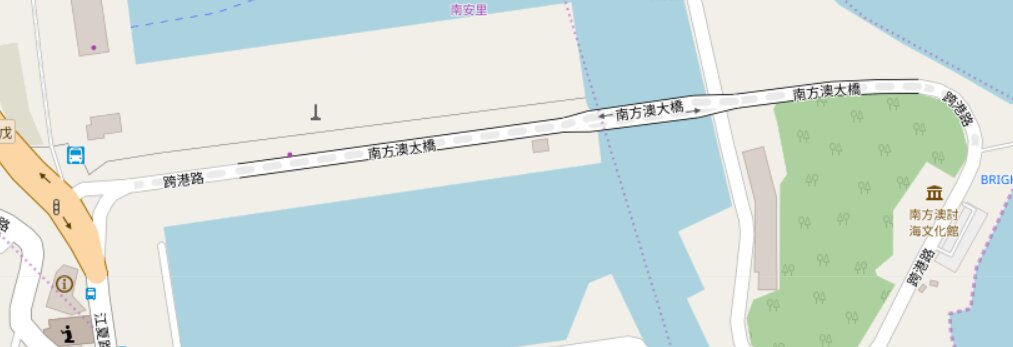
https://www.openstreetmap.org/way/145628516#map=17/24.58501/121.87045
 jidanni
All 8 comments
Here the grey dashes might be seen as just one more type of lane divider,
scenic route, bike route, historical route, truck route, or maybe a park or political border.
We're talking safety issues here.
Yes, one could say the highway bureau will certainly have barricades (hopefully in better shape than the bridge.) But even so, the user has still gone wasted miles only to find out there is no bridge anymore.
jidanni
on 1 Oct 2019
I read about this bridge collapse. Since the bridge no longer exists, it's incorrect to simply tag it as access=no which is an access restriction for real features that still are present. A lifecycle prefix like destroyed:highway=* would be more appropriate tagging for this feature. In that case it would no longer render as a highway. (I see that this is already the tagging, but for some reason it is also tagged as highway=unclassified in addition to destroyed:highway=unclassified -https://www.openstreetmap.org/way/145628516/history)
A bridge that was closed to all traffic would render as above. There are been some suggestions about changing the access rendering in #3645 which is partially a duplicate of this issue. Also see #3724 about z16 with highway=service + access=no.
The specific suggestion to use 🚫 or ⛔ icons for access=no is not feasible for this map style at all zoom levels, however: adding one icon at the center would still lead to a very busy rendering for areas like military bases with many access=no roads, especially where highway ways are split at intersections, which would lead to duplicate icons on each way segment.
So I believe this issue can be closed as a duplicate of #3645.
 jeisenbe
on 2 Oct 2019
jeisenbe
on 2 Oct 2019
Indeed as there is no SOP yet in such cases, each time there are such worldwide news making bridge collapses many editors pitch in trying to do (their own version of) the right thing.
jidanni
on 2 Oct 2019
Yes ripping the bridge off the map will make it clear to drivers that they are not going to get across the river. Good!
However mappers might worry:
- "Well the bridge is actually still there, although lying in the river, until they dig it out (weeks). I dare not remove it completely."
- "The Minister said they will get to work rebuilding the bridge as soon as the human rescue operation is finished. So the bridge is merely temporarily closed, one might say. I can't just rip it out like it never existed."
So some tagging SOP needs to be established.
If ripping it out is the new SOP, then I suppose one can keep the grey dashes, for bridges closed to cars, but which joggers could perhaps still use.
jidanni
on 2 Oct 2019
@jidanni - your argumentation is hard to follow. I have no idea what you mean by SOP, too many meanings. Please remember that the carto style can only represent a subsection from the OSM data, and is not a traffic sign map.
There are several lifecycle tags to use for the stages of replanning and reconstruction, and as soon as work has started you can use the construction tag which will be rendered here.
 polarbearing
on 2 Oct 2019
polarbearing
on 2 Oct 2019
https://en.wikipedia.org/wiki/Standard_operating_procedure
All I know is with people blindly following electronic maps into
mud holes and off cliffs these days, it should be extra clear that they
should not attempt driving on it, even when viewed on a dimly lit
screen. Those grey dashes just don't pass the test.
(Sure, if the bridge is no longer present on the map, the problem goes away.)
jidanni
on 2 Oct 2019
But this is rendering style, not a routing service. I don't believe anybody would drive looking at this particular map, not hearing their GPS assistant.
 kocio-pl
on 2 Oct 2019
kocio-pl
on 2 Oct 2019
(Off topic: All I know is I use these maps in real life all the time,
loaded into
https://play.google.com/store/apps/details?id=net.psyberia.offlinemaps
But the offline nature means I'll often be working with cached tiles...
so can't blame the map when I end up in the water.
Hmmm, the cycle and transport layers aren't expected to be updated fast
either, and who knows what
https://play.google.com/store/apps/details?id=com.mapswithme.maps.pro
uses instead of those dashes...)
jidanni
on 4 Oct 2019
Related issues
 dktue
·
4Comments
dktue
·
3Comments
dktue
·
4Comments
dktue
·
3Comments
 HolgerJeromin
·
3Comments
HolgerJeromin
·
3Comments
 Thorwynn
·
3Comments
Thorwynn
·
3Comments
 manfredbrandl
·
5Comments
manfredbrandl
·
5Comments
Most helpful comment
But this is rendering style, not a routing service. I don't believe anybody would drive looking at this particular map, not hearing their GPS assistant.