Openstreetmap-carto: land has same background as water
This is happening on openstreetmap.org, but I dont know how to report it
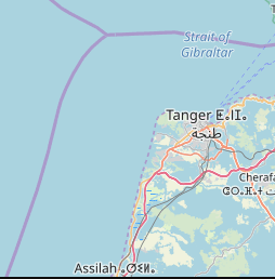
https://c.tile.openstreetmap.org/9/247/201.png
The same happens in Spain and Saudi arabia... I guess it is a consequence of global warming ;)
 brunesto
All 17 comments
It is almost certainly data issue and should be gone now or in the near future, not caused by a bug in the map style.
Try to refresh cache - almost certainly data and rendering is now fixed.
In unlikely case that it persists - please comment.
 matkoniecz
on 28 May 2019
matkoniecz
on 28 May 2019
It is still happening, but not systematically:
$ for i in `seq 1 10`; do wget https://a.tile.openstreetmap.org/9/247/201.png; done
$ md5sum 201.png*
e9ff649247d76499ecc6d9234ab92ff7 201.png
a98d4b11842a1108c90cfa2e56b80ae5 201.png.1
e9ff649247d76499ecc6d9234ab92ff7 201.png.2
7e4e16062f4aafe39ebe113733534b97 201.png.3
a98d4b11842a1108c90cfa2e56b80ae5 201.png.4
a98d4b11842a1108c90cfa2e56b80ae5 201.png.5
a98d4b11842a1108c90cfa2e56b80ae5 201.png.6
a98d4b11842a1108c90cfa2e56b80ae5 201.png.7
a98d4b11842a1108c90cfa2e56b80ae5 201.png.8
a98d4b11842a1108c90cfa2e56b80ae5 201.png.9
a98d4b11842a1108c90cfa2e56b80ae5 are the ones with blue background color for land
brunesto
on 29 May 2019
I found the reason for the Arabian peninsula becoming blue. It was caused by a editing mistake. Changeset 70664569 changed the Arabia Peninsula (relation 5631846) from place=peninsula to natural=water. Because the of Strait of Hormuz was changed from natural=strait to natural=water in the same changeset, I decided to revert the whole changeset.
How did I find it? I searched OSMCha for changesets between 27 and 28 May 2019 which have been flagged by any validation rule. Changes to large waterbodies are catched by at least one rule. I limited the number of results by adding a bbox filter around the Arabian Peninsula. The changeset in question was the 8th item in the list of results.
 Nakaner
on 29 May 2019
Nakaner
on 29 May 2019
Thank you for fixing those errors
 jeisenbe
on 29 May 2019
jeisenbe
on 29 May 2019
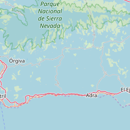
I see the same issue in south of Spain:
https://a.tile.openstreetmap.org/9/251/199.png
(again it does not pop up in blue everytime, maybe 50%)
After reading comment from Nakaner I checked the iberian peninsula https://www.openstreetmap.org/relation/3870917 but it has does not have any tag with value 'water' ... So i don't know what is causing the problem there (or if it has already been fixed and I am just seeing some old tiles)
brunesto
on 29 May 2019
old tiles
Have you tried clearing browser cache?
https://www.openstreetmap.org/#map=8/36.847/-4.098 for me is without flood
matkoniecz
on 29 May 2019
I used wget to directly query the tile and avoid browser cache.
Now if I use the browser I see some tiles with water on zoom level 9 (but not 8)
https://www.openstreetmap.org/#map=9/36.8470/-4.0980
brunesto
on 29 May 2019
@matkoniecz, it seems to be happening here on Z18 also. It doesn't look like there's any data around the borders of it either like it was mapped by someone. I'm the only one that really edits that area. Are you sure its not something caused by the last Carto release? Like maybe bleed out from a pond around there or something? I thought @jeisenbe did something related to water bodies in the last release. If so, it could be a regression.
If it's not a bug and it's a vandal could you look into it and have them blocked? Because I'm not seeing any edits around there besides mine. Unless I'm missing something.
 Adamant36
on 30 May 2019
Adamant36
on 30 May 2019
@matkoniecz, it still seems to be going on at the place I linked to.
Adamant36
on 6 Jun 2019
Now the tiles for Tangier https://c.tile.openstreetmap.org/9/247/201.png are displayed correctly.
@Adamant36 , I just tried against one tile in the area you mentioned. The tiles returned were always of the correct land background color, so probably you are seeing old tiles cached by your browser.
bash script to retrieve 10 times a tile against a,b,and c tiles server:
for x in a b c; do mkdir $x; cd $x; for i in `seq 1 10`; do wget https://$x.tile.openstreetmap.org/18/41857/99161.png ; done ; cd .. ; done
so probably you are seeing old tiles cached by your browser.
I doubt it would be cached still 7 days later. I've restarted my computer a bunch of times between then.
Adamant36
on 6 Jun 2019
@brunesto, can you check here https://www.openstreetmap.org/#map=18/40.08416/-122.51376
Adamant36
on 6 Jun 2019
@Adamant36, on the browser it looks fine for me, I also ran the bash script against tile
18/41859/99161
For me the tile returned is always with correct land background
brunesto
on 6 Jun 2019
Hmm, weird. Must be the cache then. Thanks for checking.
Adamant36
on 6 Jun 2019
I doubt it would be cached still 7 days later. I've restarted my computer a bunch of times between then.
There are many places where caching can be. Please try another browser or even another computer.
 HolgerJeromin
on 6 Jun 2019
HolgerJeromin
on 6 Jun 2019
Another problem was visible lately, here is some explanation what might be the reason if that happens:
https://lists.openstreetmap.org/pipermail/talk-au/2019-June/012719.html
 kocio-pl
on 17 Jun 2019
kocio-pl
on 17 Jun 2019
Thanks for the link. I had seen it happen a few times again and I was totally thinking there was probably more to it then just a caching issue. It seemed there was resistance to the suggestion of it being another issue though 🤷♂
Adamant36
on 18 Jun 2019
Related issues
 manfredbrandl
·
5Comments
manfredbrandl
·
5Comments
 boothym
·
5Comments
boothym
·
5Comments
 d3netxer
·
4Comments
d3netxer
·
4Comments
 Vort
·
3Comments
Vort
·
3Comments
 Thorwynn
·
3Comments
Thorwynn
·
3Comments
Most helpful comment
I found the reason for the Arabian peninsula becoming blue. It was caused by a editing mistake. Changeset 70664569 changed the Arabia Peninsula (relation 5631846) from
place=peninsulatonatural=water. Because the of Strait of Hormuz was changed fromnatural=straittonatural=waterin the same changeset, I decided to revert the whole changeset.How did I find it? I searched OSMCha for changesets between 27 and 28 May 2019 which have been flagged by any validation rule. Changes to large waterbodies are catched by at least one rule. I limited the number of results by adding a bbox filter around the Arabian Peninsula. The changeset in question was the 8th item in the list of results.