Openstreetmap-carto: Adding rendering for emergency=assembly_point
Emergency Assembly Points are designated places where people have to wait in the event of a fire or other emergency (flood, tornado, earthquake, tsunami, ...):
https://wiki.openstreetmap.org/wiki/Tag:emergency%3Dassembly_point
Usage: 8374 entries
https://taginfo.openstreetmap.org/tags/emergency=assembly_point
For example this SVG Image (2 colors: red and transparency):
https://github.com/wilmaed/foo/blob/master/yassembly.svg
14x14px:

Example:

Maybe different colors for different types:
assembly_point:tsunami
assembly_point:fire
assembly_point:flood
assembly_point:tornado
assembly_point:earthquake
 wilmaed
All 16 comments
I would render it on z19+ and I guess one color for all of them is enough. This icon looks OK for me.

 kocio-pl
on 10 Jan 2019
kocio-pl
on 10 Jan 2019
The icon does not work for me. :-(
Edit: oh, these are arrows! It was a strange cross for me!
https://commons.m.wikimedia.org/wiki/File:Eisernes_Kreuz_2.Klasse_1813.jpg
 HolgerJeromin
on 13 Jan 2019
HolgerJeromin
on 13 Jan 2019
Perhaps thinner arrows would help? Maybe only 3 instead of 4?
On Sun, Jan 13, 2019 at 3:49 PM Holger Jeromin notifications@github.com
wrote:
The icon does not work for me. :-(
—
You are receiving this because you are subscribed to this thread.
Reply to this email directly, view it on GitHub
https://github.com/gravitystorm/openstreetmap-carto/issues/3632#issuecomment-453806830,
or mute the thread
https://github.com/notifications/unsubscribe-auth/AoxshE6grNLCTXCgBJi-KEBox8nTyqH8ks5vCtbmgaJpZM4Z6KVM
.
 jeisenbe
on 13 Jan 2019
jeisenbe
on 13 Jan 2019
Perhaps thinner arrows would help? Maybe only 3 instead of 4?
…
On Sun, Jan 13, 2019 at 3:49 PM Holger Jeromin @.*> wrote: The icon does not work for me. :-( — You are receiving this because you are subscribed to this thread. Reply to this email directly, view it on GitHub <#3632 (comment)>, or mute the thread https://github.com/notifications/unsubscribe-auth/AoxshE6grNLCTXCgBJi-KEBox8nTyqH8ks5vCtbmgaJpZM4Z6KVM .
3 Arrows
14px:

SVG:
https://github.com/wilmaed/foo/blob/master/zassembly.svg
wilmaed
on 13 Jan 2019
Usage graph from https://github.com/gravitystorm/openstreetmap-carto/issues/3632#issuecomment-453235445 looks extremely suspicious to me. Such jump indicates mass retagging (what may be OK or not) or import. What caused it? How many uses are actually mapped by mappers?
 matkoniecz
on 23 Jan 2019
matkoniecz
on 23 Jan 2019
The 4 arrows is what I'd remember from such signs (though they are diagonal, search 'assembly point symbol').
Anyway I'd be against rendering, and not at all in emergency colour. These points are of relevance in relation to a particular building. Thus there might be different points for different buildings in proximity, or even different points for different parts/populations in the same building. The general map cannot show such relations.
 polarbearing
on 23 Jan 2019
polarbearing
on 23 Jan 2019
different points for different parts/populations in the same building.
Probably not for something like a:tsunami. Everyone is going to run to higher ground no matter population they are a member of. Its also, not as building dependent as something like a fire or a tornado. I agree that other then those tags, except maybe earthquakes. its to specific a tag. It would be worth rendering once the sub tags get more usage though and the icons can be specific. As it is assembly_point:tsunami=yes only has 7 usages. Or conversely assembly_point:fire=yes could just be left out of it.
Also, I think this is an edition that people in "third world countries" would appreciate, especially assembly_point:tsunami=yes, which is something that has been suggested the style do more of.
 Adamant36
on 23 Jan 2019
Adamant36
on 23 Jan 2019
There are different purposes for such points. One is to seek refuge (your tsunami example), another is to count heads (like in a fire in a school/company) to see if somebody is missing (muster/assembling point).
The tag appears to be badly designed in this differentiation, together with the suspicious import I'd suggest to reject for now.
I also found the suspicious import, it is in Taiwan, and all I probed are shelter-functions of public buildings in a case of emergency. The tag emergency=assembly_point is not well chosen for those. About 5000 nodes and 670 polygons: https://overpass-turbo.eu/s/Fu5
Example:
    addr:country=TW
    addr:full=嘉義縣水上鄉水上村正義路141號
    building=office
    description=水上鄉公所三樓
    emergency=assembly_point
    emergency:amenity=social_facility
    emergency:shelter_type=水災
    emergency:social_facility=shelter
    emergency:social_facility:association_villages=鄉公所附近村民;無收容所之村
    emergency:social_facility:for=displaced_people
    emergency:social_facility:id=1781
    emergency:social_facility:source=內政部消防署
    evacuation_center=yes
    name=水上鄉公所
    office=government
I also found the suspicious import, it is in Taiwan, and all I probed are shelter-functions of public buildings in a case of emergency. The tag emergency=assembly_point is not well chosen for those. About 5000 nodes and 670 polygons: https://overpass-turbo.eu/s/Fu5
Thanks! I wanted to look for this one!
matkoniecz
on 23 Jan 2019
My first problem with rendering this tag is that without knowing whatever it is assembly point in case of tsunami, fire, artillery strike or earthquake it is not really useful.
I would also expect that evacuation point would be known for all people around (or at least to ones supposed to control evacuation) or clearly marked - otherwise it would not be useful at all.
And I see little value in showing points where out map would be the most useful guide in finding it - it would mean that such point is utterly worthless and not worth showing.
I am not convinced that showing it would be helpful.
matkoniecz
on 23 Jan 2019
https://www.openstreetmap.org/changeset/49214137 has one of the discussions about the import, I left a comment there.
polarbearing
on 23 Jan 2019
I am planning to close this issue as declined for reasons mentioned two and three comments ago and because majority of mapped objects is from a questionable import.
Note that "map of Taiwan would be horrifyingly ugly as broken import would become visible" is not a problem, that would be actually a benefit.
matkoniecz
on 25 Jan 2019
If someone thinks that my arguments can be contradicted or has good arguments why it should be rendered despite problems that I mentioned- this is the best moment to mention them.
matkoniecz
on 25 Jan 2019
In favour of closing.
polarbearing
on 25 Jan 2019
I am closing, though if anyone has good counterarguments - please comment (especially if you are visiting github rarely and missed discussion), issues can be easily reopened.
one additional problem is that proposed icons, especially
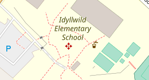
for me look like gunsight or a military target what would lead to rather unwelcomed confusion.
matkoniecz
on 25 Jan 2019
for me look like gunsight or a military target what would lead to rather unwelcomed confusion.
Probably not a good symbol to have in the middle of a school. At least here in America.
Adamant36
on 25 Jan 2019
Related issues
 wielandb
·
3Comments
wielandb
·
3Comments
 Tomasz-W
·
4Comments
Tomasz-W
·
4Comments
 Thorwynn
·
3Comments
Thorwynn
·
3Comments
 d1g
·
4Comments
d1g
·
4Comments
 MarkusStue
·
4Comments
MarkusStue
·
4Comments
Most helpful comment
The 4 arrows is what I'd remember from such signs (though they are diagonal, search 'assembly point symbol').
Anyway I'd be against rendering, and not at all in emergency colour. These points are of relevance in relation to a particular building. Thus there might be different points for different buildings in proximity, or even different points for different parts/populations in the same building. The general map cannot show such relations.