I think it would be helpful to have a terrain/relief view like in Google Maps or hiking maps in general, to get an idea of where mountains are on my route. Is that possible? Outdooractive.com has such a view, for example, and their map is also OpenStreetMap-based.
 ygoe
ygoe
All 15 comments
This topographic rendering could be like OpenTopoMap. OpenTopoMap use OSM and SRTM data, it's very usefull for hiking an biking.
 clembeb
on 31 Aug 2017
clembeb
on 31 Aug 2017
The complete map style of OpenTopoMap can be found here on Github
clembeb
on 31 Aug 2017
Hi!
We will not show terrain in offline mode - this will eat lots of space.
Maybe some day we will do it in online mode - but this is not our first priority.
 burivuh
on 31 Aug 2017
burivuh
on 31 Aug 2017
About how much space are we talking? I was rather surprised to see that all maps of my 5000 km travel route take just around 2 GB. I won't need height data for all of that, just where I'm hiking. So if space is an issue, it could be an optional download per map region.
ygoe
on 31 Aug 2017
I don't understand why a new topographic map styles will eat lots of space ? The only new data is the countour lines which could be an optional download par map region like @ygoe say.
clembeb
on 6 Sep 2017
That would be a super option. Perhaps you could offer it to download it seperatly.
 highbuilder
on 27 Jan 2018
highbuilder
on 27 Jan 2018
Vote up
 ferdymercury
on 17 Feb 2020
ferdymercury
on 17 Feb 2020
This is the main reason I am turning to fatmap today instead of mapsme (which is indeed eating A LOT of space offline but worth it). No need for satellite images, just a level line layer would be enough. Not sure to understand why it could not be implemented as you can already see the topographic profile of itinerary.
 lechinoix
on 7 Mar 2020
lechinoix
on 7 Mar 2020

This feature has been added today 🎉 (I was on the verge to add my 2 cents comment here as I'm also using Fatmap for this feature) and it have been added today (Android version 10.1.3) !
Thanks dev team; this is an huge improvement that will change my life (and my mother's and father's lifes, as well as many many other people around the world).
 brunetton
on 26 Jul 2020
brunetton
on 26 Jul 2020
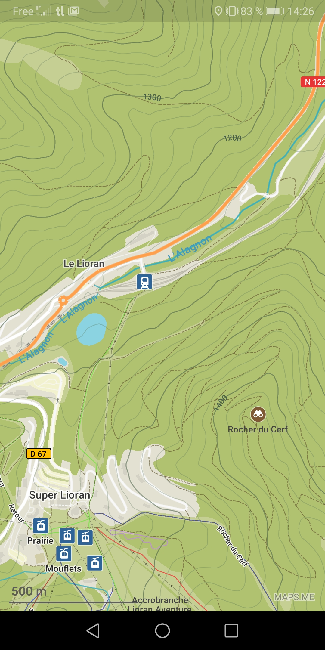
I also saw it announced in-app. Can anyone share a screenshot of how this should look? I have the updated app, and new maps. Still, in Brussels I don't see any height-indication, while when cycling this would be useful.
 keunes
on 27 Jul 2020
keunes
on 27 Jul 2020
I also saw it announced in-app. Can anyone share a screenshot of how this should look? I have the updated app, and new maps. Still, in Brussels I don't see any height-indication, while when cycling this would be useful.
Sometimes you have to zoom in to view the curves. Here's a screen shot taken around 45.088527, 2.755106
brunetton
on 27 Jul 2020
That presentation is a bit careless/uninspired (what's the word for it?). Just plotting a few lines. I find it hard to get an idea of the terrain, it's like reading numbers and having to imagine the rest. A bit of a shading like on OpenTopoMap or other comparable maps (even Google Maps terrain layer) would have a great impact.
ygoe
on 27 Jul 2020
That presentation is a bit careless/uninspired (what's the word for it?). Just plotting a few lines. I find it hard to get an idea of the terrain, it's like reading numbers and having to imagine the rest. A bit of a shading like on OpenTopoMap or other comparable maps (even Google Maps terrain layer) would have a great impact.
Of course, and it's very probable that the devs are aware of it, but as the rendering is dynamic (so in real-time) adding a shading algorithm may affect rendering efficiency and global fluidity. And it's (maybe, I don't know) quite hard to implement.
I'm personally very satisfied with this first iteration, it's waaaayyyy better than nothing. And there will probably be more iterations coming with new options (like I personally would appreciate: relief lines color choose)
brunetton
on 27 Jul 2020
The lines are hard to see indeed - colours would be helpful.
However, a more fundamental issue, IMHO: the lines only show when zoomed in quite much. This makes the terrain option quite useless when (manually, without planner) navigating: currently zooming in far is required for seeing the lines, while zooming out a bit is very often necessary for navigating.
keunes
on 28 Jul 2020
For the record, someone opened an issue about shading: https://github.com/mapsme/omim/issues/12777
brunetton
on 17 Aug 2020
Related issues
 troxler
·
8Comments
troxler
·
8Comments
 eneerhut
·
6Comments
eneerhut
·
6Comments
 sangeetaggomes
·
7Comments
sangeetaggomes
·
7Comments
 fegul
·
8Comments
fegul
·
8Comments
 nighto
·
7Comments
nighto
·
7Comments
Most helpful comment
This feature has been added today 🎉 (I was on the verge to add my 2 cents comment here as I'm also using Fatmap for this feature) and it have been added today (Android version 10.1.3) !
Thanks dev team; this is an huge improvement that will change my life (and my mother's and father's lifes, as well as many many other people around the world).