Mapsui: OpenSeaMap - Map base + overlay layer(s)
Hi,
how to create in Mapsui 1.4.8.* map like this:
https://mc.bbbike.org/mc/?lon=14.299757&lat=53.909673&zoom=12&num=1&mt0=mapnik&mt-1=ol_openseamap-seamark&mt-1p=100&marker=
https://wiki.openstreetmap.org/wiki/File:OpenSeaMap-Warnem%C3%BCnde.png
https://wiki.openstreetmap.org/wiki/File:OpenSeaMap_auf_OpenCPN-Kap-1.jpg
Generally, would like to have a base map like OpenStreetMap and an overlay like OpenSeaMap.
I try based on details from https://wiki.openstreetmap.org/wiki/Tile_servers to have:
in Map.Layers[0] is TileLayer -> OpenStreetMap
in Map.Layers[1] is TileLayer -> OpenSeaMap
and I don't see anything from OpenSeaMap :(
Help!
 lukaszpitulski
All 5 comments
[Serializable]
    public class OSM_OpenSeaMap : MapSettings
    {
        public TileLayer CreateTileLayer()
        {
            TileLayer tileLayer = new TileLayer((ITileSource)CreateTileSource(), 200, 300, 2, (IFetchStrategy)null, (IRenderGetStrategy)null, -1, -1);
            string str = nameof(OSM_OpenSeaMap);
            tileLayer.Name = str;
            return tileLayer;
        }

        private HttpTileSource CreateTileSource()
        {
            return new HttpTileSource((ITileSchema)new GlobalSphericalMercator(), "http://tiles.openseamap.org/seamark/${z}/${x}/${y}.png", (IEnumerable<string>)new string[]{}, (string)null, nameof(OSM_OpenSeaMap), (IPersistentCache<byte[]>)null, (Func<Uri, byte[]>)null, new Attribution());
//return new HttpTileSource((ITileSchema)new GlobalSphericalMercator(), "https://tiles.openseamap.org/seamark/${z}/${x}/${y}.png", (IEnumerable<string>)null, (string)null, nameof(OSM_OpenSeaMap), (IPersistentCache<byte[]>)null, (Func<Uri, byte[]>)null, (Attribution)null);
        }
    }
I will give you some pointers so you can figure this out yourself.
My approach would be in two ways.
1) See how it works on the web
Go the a web hosted openseamap site and use developer tools to see which requests are transmitted and what kind of images are returned from those.
2) Try to get it to work in Mapsui
Try to create a tile layer in Mapsui. Run it. And use fiddler (or a similar tool) to see what kind of requests are created. Then adopt your definition to match the web request.
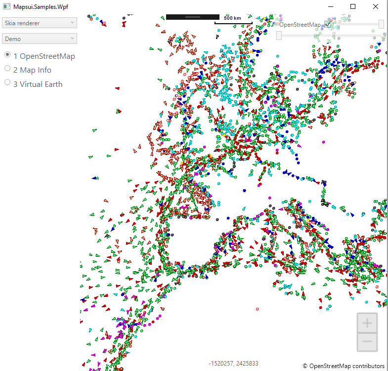
Below is something I created that way. I don't fully understand openseamap though. It seems to use openstreetmap itself as a baselayer. Then there are openseamap overlay tiles that are always empty (the files I inspected) and then there are the aspx pages that I use in the sample below.
c#
private static HttpTileSource CreateTileSource()
{
      return new HttpTileSource(new GlobalSphericalMercator(),
           "https://tiles.marinetraffic.com/ais_helpers/shiptilesingle.aspx?output=png&sat=1&grouping=shiptype&tile_size=256&legends=1&zoom={z}&X={x}&Y={y}",
           name: "OpenStreetMap",
           attribution: OpenStreetMapAttribution);
}
 pauldendulk
on 11 Dec 2018
pauldendulk
on 11 Dec 2018
pauldendulk
on 11 Dec 2018
I was looking on the html code (F12, Firefox) in the web, but maybe I should look again and closer.
With MarineTraffic overlay it works perfectly. (OSM as base map)

Thanks!
lukaszpitulski
on 11 Dec 2018
I see only these:
https://tiles.openseamap.org/seamark/12/2210/1316.png
https://b.tile.openstreetmap.org/12/2210/1316.png
nothing more.
lukaszpitulski
on 11 Dec 2018
Related issues
pauldendulk
·
7Comments
 willy40
·
6Comments
willy40
·
6Comments
 YordanYanakiev
·
6Comments
YordanYanakiev
·
6Comments
 EduardsBrown
·
5Comments
lukaszpitulski
·
3Comments
EduardsBrown
·
5Comments
lukaszpitulski
·
3Comments