Geonode: Uploading Geojson format to geonode 2.10.1, not all items in features gets uploaded
Expected Behavior
Uploading Geojson format to geonode 2.10.1, all items in features should get uploaded to the Geonode layer.
Actual Behavior
Uploading Geojson format to geonode 2.10.1, not all items in features gets uploaded. Have observed that last approximately 20% of the features are not uploaded to Geonode.
For the same layer, the shape file format has all the records in the layer.
Steps to Reproduce the Problem
- Upload the attached Geojson file to the Geonode using Upload Layers option to the http://master.demo.geonode.org/.
- After successful upload go to Editing Tools -> Layer -> Edit Data, at bottom of table 60 items will be listed. When there are 72 elements in the Geojson file
- Open the geojson file in a text editor confirms that there are 72 features but in geonode layer only 80%, (60 features) are seen.
Specifications
- GeoNode version: 2:10.1
- Installation method (manual, GeoNode Docker, SPCGeoNode Docker): Geonode Docker and http://master.demo.geonode.org/.
Platform: Geonode Dockers on Mac
Archive.zipAdditional details:
Zip file contains the Geojson and also its equivalent shape file.
 vijayr1912
All 23 comments
Maybe connected with: https://github.com/GeoNode/geonode/issues/4713
 t-book
on 26 Aug 2019
t-book
on 26 Aug 2019
Me and @vijayr1912 were trying to debug such issue, can point us to the right directions please?
 srggrs
on 4 Sep 2019
srggrs
on 4 Sep 2019
Would django-osgeo-importer app would help in loading the correct geojson?
srggrs
on 5 Sep 2019
Hello, my guess is that some lines of the GeoJSON contain invalid values.
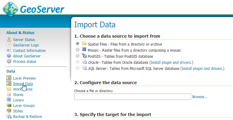
I would try first to upload it directly by using GeoServer and see what happens.
Loging into GeoServer as admin and try to upload your GeoJSON by using the Importer functionality
 afabiani
on 5 Sep 2019
afabiani
on 5 Sep 2019
Hi
Thanks for the suggestion.
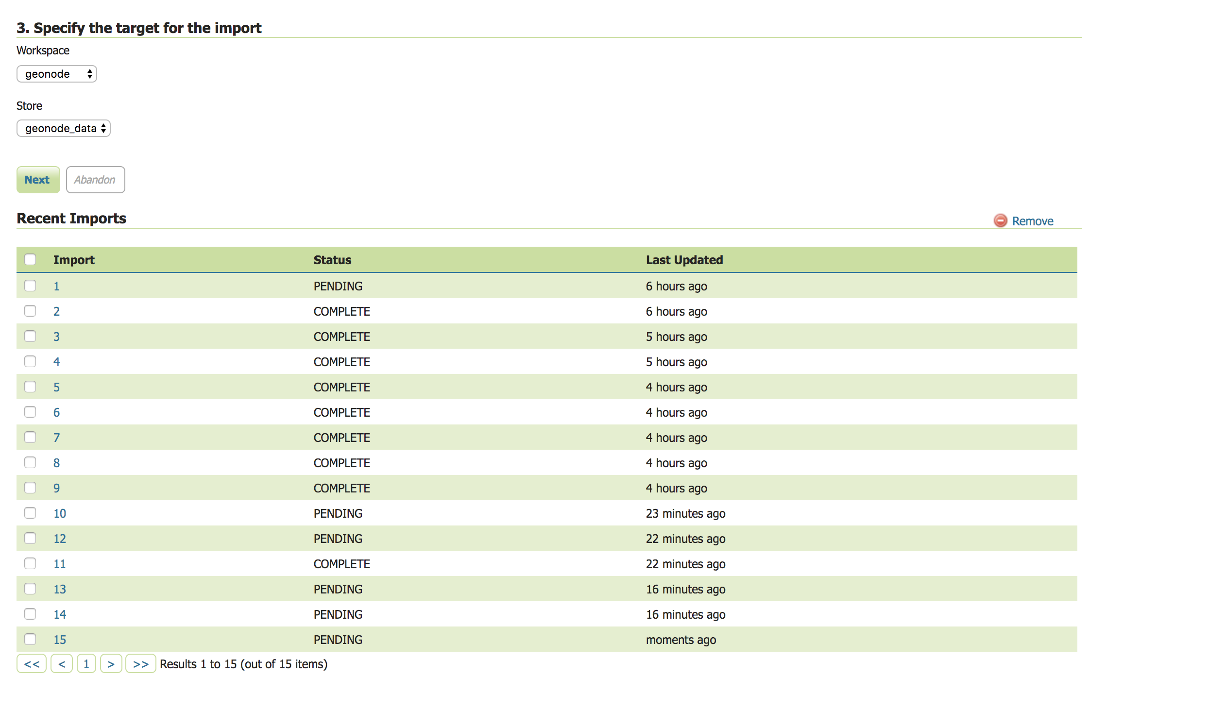
I tried to import the attached geojson file by using Import option of Geoserver. The status is shown as PENDING. whereas for shape file it gets to COMPLETE status.
The same geojson file on opening in online tool http://geojson.io shows the 72 records with its attributes.
Attached
- Geojson file used for testing as zipped file.
- Screen shot of Geoserver where the Status is stuck at Pending.
study001_ins00_Sept5_Buffer.geojson.zip
vijayr1912
on 5 Sep 2019
So, probably an issue on GeoServer importer.
I'll try to do more tests with your attached file as soon as possible. I'm afraid we will need to open a ticker on GeoServer for that.
Would be good if you could open a JIRA issue on GeoServer also, in order to try to speedup the process (hopefully).
afabiani
on 5 Sep 2019
Hi
I found a strange observation. I am attaching a zip of geojson files where the number of records are multiples of 30.
I found that
- If geojson layerhas more than 30 fields, then records that get displayed are closest to multiple of 30.
For example if layer has 72 records, 60 get uploaded and displayed as part of layer, 12 get discarded.
If layer has less than 30 records, even if it 29, it does not get reflected as records in Geonode.
If layer has less than 30 records, say 4, and if i copy paste the records to make it to 30 records or more than 30 records, then the layer records are uploaded to Geonode, though there is a duplication in records.
For all layer that is uploaded to Geonode, a corresponding layer store is created in Geoserver.
I uploaded the file using Update Layer option present in Geonode Front End.
If you can confirm you can observe the same with these files or any Geojson file downloaded and play around with 30 records we can confirm the behaviour and debug further.
All my geojson files are dealing with Polygon Geometry with "urn:ogc:def:crs:EPSG::4326" projection. We are not working with any other geometry or projections,
Thanks
Vijay
vijayr1912
on 7 Sep 2019
Yeah, I'd wondered if this bug came from some processing occurring in
batches, and the last (smaller) batch not being processed and saved by the
same code as the previous batches.
 jnothman
on 8 Sep 2019
jnothman
on 8 Sep 2019
Issue Tracker in Geoserver -
https://osgeo-org.atlassian.net/browse/GEOS-9325
vijayr1912
on 9 Sep 2019
This issue has been automatically marked as stale because it has not had recent activity. It will be closed if no further activity occurs. Thank you for your contributions.
![stale[bot] picture](https://avatars3.githubusercontent.com/in/1724?v=4&s=40) stale[bot]
on 8 Nov 2019
stale[bot]
on 8 Nov 2019
up
afabiani
on 8 Nov 2019
It would be good to keep an eye on the status of this in geoserver
jnothman
on 10 Nov 2019
This issue has been automatically marked as stale because it has not had recent activity. It will be closed if no further activity occurs. Thank you for your contributions.
stale[bot]
on 9 Jan 2020
I think this is a severe issue, and should not be wontfixed, but should be tested and tracked.
jnothman
on 9 Jan 2020
If geojson layerhas more than 30 fields, then records that get displayed are closest to multiple of 30.
For example if layer has 72 records, 60 get uploaded and displayed as part of layer, 12 get discarded.
This sounds like a wrong for loop somehow. Maybe they switched rows/columns somehow? Or do not drill properly through the geojson with for each?
 gannebamm
on 14 Feb 2020
gannebamm
on 14 Feb 2020
Would postpone this to get 3.0 faster
This seems to be an harder to tackle issue. In the meantime I would disable GeoJSON uploads.
gannebamm
on 31 Mar 2020
This issue has been automatically marked as stale because it has not had recent activity. It will be closed if no further activity occurs. Thank you for your contributions.
stale[bot]
on 1 Jun 2020
up
t-book
on 1 Jun 2020
Having the same issue in 3.0 here, both with geoJSON and KML, only regions up to a multiple of 30 are loaded in the layer. 90 out of 98 on a map, and 990 out of 1018 on another.
 bruno-ichec
on 22 Jul 2020
bruno-ichec
on 22 Jul 2020
This issue has been automatically marked as stale because it has not had recent activity. It will be closed if no further activity occurs. Thank you for your contributions.
stale[bot]
on 22 Sep 2020
I think closing this remains a bad idea. Or disable GeoJSON first, per https://github.com/GeoNode/geonode/issues/4770#issuecomment-606420905
jnothman
on 30 Sep 2020
@afabiani do your clients use GeoJSON uploads? They are broken and I would strongly advise to disable this format untill we have a clear idea how to fix it. (disclaimer: haven´t tested it with the new GeoServer version though)
gannebamm
on 1 Oct 2020
Sometimes Issues just get resolved. I can not reproduce the error anymore with geonode master. See:
https://master.demo.geonode.org/maps/new?layer=geonode:study001_ins00_Buffer&view=True
https://master.demo.geonode.org/maps/new?layer=geonode:study001_ins00_Buffer_geoJSON&view=True
If others face the issue again, please reopen.
gannebamm
on 7 Oct 2020
Related issues
 capooti
·
8Comments
afabiani
·
8Comments
afabiani
·
8Comments
capooti
·
8Comments
afabiani
·
8Comments
afabiani
·
8Comments
 malnajdi
·
3Comments
capooti
·
8Comments
malnajdi
·
3Comments
capooti
·
8Comments
Most helpful comment
I think this is a severe issue, and should not be wontfixed, but should be tested and tracked.