Covid19india-react: Map data discrepancies
From my tests in #355 I have found out the following discrepancies in the districts' data:
Describe the bug
1) Arunachal Pradesh
The API response has the state name as Arunachal Pradesh
In the public/maps/arunachalpradesh.json it is spelled wrongly as Arunanchal Pradesh
2) Andaman and Nicobar Islands
The API response has the state name as: Andaman and Nicobar Islands
In the public/maps/andamannicobarislands.json.json it's Andaman & Nicobar Island
3) Chandigarh
The state is there in API response but the map file does not exist. Nor it is listed in mapsexplorer.js
4) Puducherry
The state is there in API response but the map file does not exist. Nor it is listed in mapsexplorer.js
5) Chengalpattu (A district of Tamilnadu)
This district is there in the API response but could not find under public/maps/tamil-nadu.json
6) Bhadradri Kothagudem (A district from Telangana)
This district is there in the API response but could not find under public/maps/tamil-nadu.json
 tannakartikey
All 7 comments
I am not sure how we are gathering map data at the moment.
Just mentioning a few resources I found in case it helps:
https://github.com/HindustanTimesLabs/shapefiles/tree/master/india
https://github.com/deldersveld/topojson/tree/master/countries/india
tannakartikey
on 2 Apr 2020
I am not sure how we are gathering map data at the moment.
Just mentioning a few resources I found in case it helps:
https://github.com/HindustanTimesLabs/shapefiles/tree/master/india
https://github.com/deldersveld/topojson/tree/master/countries/india
@tannakartikey Maps in the above links provided by you are old ones. Total number of Districts in the country at present 729 as per latest data updated in 2018/2019.
 khaaba
on 2 Apr 2020
khaaba
on 2 Apr 2020
@JunaidBabu @sudevschiz @jeremyphilemon
I would like to work on this.
 KrishnaPravin
on 3 Apr 2020
KrishnaPravin
on 3 Apr 2020
@tannakartikey @KrishnaPravin we are working on these. See #413 the source for the latest district data is the Datameet community. I am currently working on the topojsons and hosting them in this repo https://github.com/guneetnarula/indian-district-boundaries/tree/master/topojson
 guneetnarula
on 5 Apr 2020
guneetnarula
on 5 Apr 2020
@guneetnarula got it👍
KrishnaPravin
on 5 Apr 2020
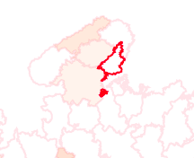
datiya district in Madhya pradesh, the map of Datiya shows extra villages geographically seperated. these are not correct.
 limshark
on 6 Apr 2020
limshark
on 6 Apr 2020
Hi @limshark I checked the official SoI / NIC service at bharatmaps.gov.in, the block Datia in this district has panchayats that geographical separated from the main Datia district.
guneetnarula
on 7 Apr 2020
Related issues
 mohammedrehan275
·
6Comments
mohammedrehan275
·
6Comments
 tshrwbl
·
5Comments
tshrwbl
·
5Comments
 ikshitiz
·
4Comments
ikshitiz
·
4Comments
 ninjakx
·
3Comments
ninjakx
·
3Comments
 iDhruv22
·
6Comments
iDhruv22
·
6Comments
Most helpful comment
@tannakartikey @KrishnaPravin we are working on these. See #413 the source for the latest district data is the Datameet community. I am currently working on the topojsons and hosting them in this repo https://github.com/guneetnarula/indian-district-boundaries/tree/master/topojson