Cartodb: Review SQL errors for `select existing_column from...`
Context
This ticket is related to https://github.com/CartoDB/cartodb/pull/13631.
Steps to Reproduce
- Open the SQL console
- Enter:
SELECT cartodb_id FROMorSELECT 1 as X FROM - Check the SQL Error
Current Result
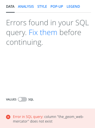
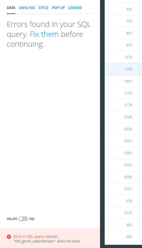
Now it returns an Error in SQL query: ... error.
Expected result
They should return a The column does not exist warning. This may be related with the Maps API responses.
 Jesus89
All 22 comments
The API is returning:
{
  "error": [
    "column \"the_geom_webmercator\" does not exist"
  ]
}
so that's what we're showing, should the API return something different?
 rubenmoya
on 12 Mar 2018
rubenmoya
on 12 Mar 2018
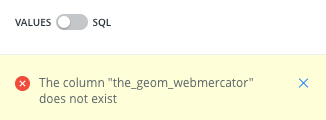
This should show a warning.
For example as the SELECT the_geom FROM warning, without the Fix them windows.
Jesus89
on 12 Mar 2018
When using SELECT the_geom the query is applied, and fails later, when using SELECT cartodb_id the query fails before being applied.
Basically, one of them is failing at Builder level, and the other one at Cartodb.js level, we're handling the errors differently, also, we're using different Notifiers...
rubenmoya
on 12 Mar 2018
Yes, that is true.
Please talk to @ramiroaznar and the @CartoDB/solutions team to define the correct behavior for this situation.
Jesus89
on 12 Mar 2018
When selecting cartodb_id or any thematic column should not fail but gives you a notification.
 ramiroaznar
on 12 Mar 2018
ramiroaznar
on 12 Mar 2018
We're about to deploy in the next days a refactor that affects the state of layers (empty, no geom, geocodable...)
Please freeze this issue until that is deployed to avoid conflicts or provoking a regression.
Particularly with https://github.com/CartoDB/cartodb/issues/13642#issuecomment-372261001, we have a conflict.
In this ticket https://github.com/CartoDB/cartodb/issues/13478 the UI state for any layer that has no geometry but it's because an SQL or analysis is one where we have to show a particular text. This is not yet released so it's better to wait until this is merged https://github.com/CartoDB/cartodb/pull/13628
 ivanmalagon
on 13 Mar 2018
ivanmalagon
on 13 Mar 2018
Blocked until https://github.com/CartoDB/cartodb/pull/13628 is merged.
ivanmalagon
on 13 Mar 2018
Unblocked. This issue can continue its path.
ivanmalagon
on 16 Mar 2018

ramiroaznar
on 16 Mar 2018
I honestly don't find any problem in current behaviour.
I mean, you are selecting something that can't be digested by our platform because it lacks needed columns.
SELECT cartodb_id FROM shows ->
SELECT the_geom FROM shows ->
I get the point that they are two similar problems with different ways of communicating the users but in both cases there's an error that the user must correct and the app tells them.
I don't find this ticket worthy. I must dig into the code, change the way errors are now diggested with some probability of breaking something... and I don't feel it like broken.
What's your take, @ramiroaznar ?
ivanmalagon
on 28 Mar 2018
Let me explain. Maybe the errors should be kept as they are. These errors tell you that there are missing fields that you need to render the map. But the thing is that when selecting fields different than the geometries such as cartodb_id and/or thematic data, the DATA panel should show you the fields.
Because with these fields you can play with analysises for instance...
ramiroaznar
on 28 Mar 2018
I don't want to hijack or speak out of turn, but I hope this is useful idea at least - it would be awesome if some of text from the error message was a clickable link ... to a page in our documentation, which explains the required columns and how the user can fix it etc.
New users may not have a clue what they are supposed to do to fix it, and if we can steer them in the right direction and make them feel less stupid, I think we would get better experience in these cases?
 stevelewis99
on 28 Mar 2018
stevelewis99
on 28 Mar 2018
@stevelewis99 BUILDER messaging that's something we need to give a lot of love, already discussed with @alonsogarciapablo
ramiroaznar
on 28 Mar 2018
Understood @ramiroaznar
Taking a look but I'm 99% sure that we can't show the data fields. We retrieve them from SQL API and the calls to it (since the SQL is badly formed) return error. So no schema is returned and we can't assure what fields the table has.
Let me check if I can do something about it.
ivanmalagon
on 28 Mar 2018
So... I'll leave it here for the next responder.
The issue is
When a user wants to filter only certain columns, they must show up in the list of columns.
So if I edit the SQL and apply...

... even if the layer is wrong (we can't visualize the points because there are no geom columns, users expect those columns to appear in the list.
It's a bit tricky since the layer is wrong and that won't have the same behaviour for all combinations.
I leave ongoing work on the branch https://github.com/CartoDB/cartodb/tree/13642-sql-messages
Bear in mind the acceptance of previous tasks related to this one:
https://github.com/CartoDB/cartodb/pull/13631
https://github.com/CartoDB/cartodb/pull/13628 (Acceptance of user flow)
ivanmalagon
on 28 Mar 2018
If the user does not select any geometry, the query is not being saved at all. There's server side validation for this, and it will return a 400 error if there's no geometry.
If we hack the frontend to ignore the response and save the query anyways, the map breaks.
If the user selects geometry, but does not select cartodb_id, the map breaks, and widgets won't work (they rely on cartodb_id). Even if we show the columns on the data tab, and let the user add them, they won't work, because apparently everything relies on cartodb_id. The query is persisted in this case because cartodb_id is not checked apparently.
So I don't think it's too bad that the user gets prompted with an error if they are not providing the correct columns. We could definitely improve the usability though.
If the user provides all the required columns and extra ones, they should show up there.
 rjimenezda
on 3 Apr 2018
rjimenezda
on 3 Apr 2018
If the user does not select any geometry, the query is not being saved at all. There's server side validation for this, and it will return a 400 error if there's no geometry.
You are right...
So I don't think it's too bad that the user gets prompted with an error if they are not providing the correct columns. We could definitely improve the usability though.
What do you suggest?
ramiroaznar
on 3 Apr 2018
For me it's obvious that a column is missing, because the error is shown below. Although the first time that this happens to you, you have to go through several errors until you have a working query.
It might be enough providing a link to some docs stating what columns are mandatory, and maybe improving the copy? Like stating that the_geom_webmercator and cartodb_id are mandatory. I think the_geom is not 100% required as long as there's the_geom_webmercator.
We could handhold the user even more, and automagically select cartodb_id and geometry if they don't, but I'm sure this has not been done for a very good reason.
rjimenezda
on 3 Apr 2018
automagically select cartodb_id and geometry if they don't
🙏 😄
but for sure, the documentation idea sounds like a big improvement even, as it's not that obvious unless _you know_
stevelewis99
on 3 Apr 2018
I completely disagree about automatically selecting everything. Let's go for pointing to the docs. But I think if the query is not saved, this ticket has lost its initial goal.
ramiroaznar
on 3 Apr 2018
And...
I think the_geom is not 100% required as long as there's the_geom_webmercator.
AFAIK in BUILDER, the_geom is mandatory to be used in analysis and widgets.
ramiroaznar
on 3 Apr 2018
@Jesus89 @ivanmalagon After talking to @rjimenezda, we are going to close this issue. Better errors should be given to explain to the users how to remake their SQL queries. But this could be added to bigger project as started here.
ramiroaznar
on 3 Apr 2018
Related issues
 santisaez
·
5Comments
santisaez
·
5Comments
 arianaescobar
·
5Comments
arianaescobar
·
5Comments
 xavijam
·
5Comments
xavijam
·
5Comments
 javitonino
·
5Comments
javitonino
·
5Comments
 rochoa
·
4Comments
rochoa
·
4Comments