Turf: Circle produces ellipsis (oval) geometry
import circle from '@turf/circle';
then i create a circle:
let coords = [
    55.837150763618574,
    37.48126387596131,
];

let radius = 70; // in meters

let options = {
    steps: 32,
    units: 'kilometers',
};

let c = circle(coords, radius / 1000, options);
and if i use circle's geometry coordinates to build a polygon and put in on some map:
console.log(c.geometry.coordinates)
it in fact looks like an ellipsis, not circle.
 artuska
All 17 comments
@artuska is this the result of your c circle?
{ "type": "Feature", "properties": {}, "geometry": { "type": "Polygon", "coordinates": [ [ [ 55.837150763618574, 37.48189340021592 ], [ 55.83699599739332, 37.48188130398295 ], [ 55.836847178892874, 37.481845480146994 ], [ 55.836710027252124, 37.48178730543068 ], [ 55.836589813214154, 37.48170901550469 ], [ 55.83649115656599, 37.481613619064746 ], [ 55.83641784859833, 37.48150478220026 ], [ 55.83637270641282, 37.48138668749987 ], [ 55.836357464674926, 37.481263873309395 ], [ 55.836372708970536, 37.48114105932079 ], [ 55.836417853324384, 37.481022965195265 ], [ 55.83649116274087, 37.48091412919113 ], [ 55.83658981989779, 37.480818733766014 ], [ 55.83671003342699, 37.48074044485487 ], [ 55.836847183618914, 37.4806822709989 ], [ 55.83699599995105, 37.480646447737804 ], [ 55.837150763618574, 37.4806343517067 ], [ 55.837305527286105, 37.480646447737804 ], [ 55.83745434361823, 37.4806822709989 ], [ 55.83759149381015, 37.48074044485487 ], [ 55.83771170733936, 37.480818733766014 ], [ 55.83781036449628, 37.48091412919113 ], [ 55.83788367391276, 37.481022965195265 ], [ 55.83792881826662, 37.48114105932079 ], [ 55.83794406256222, 37.481263873309395 ], [ 55.837928820824324, 37.48138668749987 ], [ 55.83788367863881, 37.48150478220026 ], [ 55.83781037067116, 37.481613619064746 ], [ 55.837711714023, 37.48170901550469 ], [ 55.83759149998503, 37.48178730543068 ], [ 55.83745434834428, 37.481845480146994 ], [ 55.837305529843825, 37.48188130398295 ], [ 55.837150763618574, 37.48189340021592 ] ] ] } }
I don't see anything wrong with it:
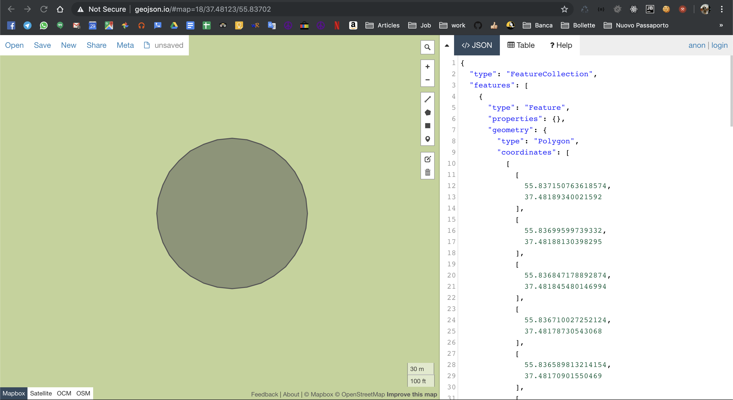
Which version of Turf are you using? I ran the code with v5.1.6
 stebogit
on 20 Nov 2019
stebogit
on 20 Nov 2019
@stebogit i'm using latest "@turf/turf": "5.1.6" version.
My circle is:
{"type":"Feature","properties":{},"geometry":{"type":"Polygon","coordinates":[[[55.837150763618574,37.48207326428866],[55.836951778002025,37.48205771195205],[55.83676043953173,37.4820116526288],[55.8365841014418,37.48193685640694],[55.8364295404424,37.48183619774427],[55.83630269627394,37.481713544992225],[55.8362084434388,37.48157361172272],[55.83615040388426,37.481421775573786],[55.8361308078339,37.48126387157753],[55.836150408112324,37.48110596791498],[55.83620845125124,37.48095413271632],[55.83630270648139,37.48081420086902],[55.83642955149087,37.480691549794564],[55.836584111649245,37.480590892809495],[55.83676044734418,37.48051609800983],[55.83695178223009,37.480470039636856],[55.837150763618574,37.480454487633956],[55.83734974500706,37.480470039636856],[55.837541079892965,37.48051609800983],[55.837717415587896,37.480590892809495],[55.837871975746275,37.480691549794564],[55.83799882075576,37.48081420086902],[55.83809307598591,37.48095413271632],[55.83815111912482,37.48110596791498],[55.83817071940325,37.48126387157753],[55.83815112335289,37.481421775573786],[55.838093083798356,37.48157361172272],[55.837998830963215,37.481713544992225],[55.83787198679475,37.48183619774427],[55.837717425795354,37.48193685640694],[55.83754108770541,37.4820116526288],[55.83734974923512,37.48205771195205],[55.837150763618574,37.48207326428866]]]}}
artuska
on 20 Nov 2019
@stebogit wow, i copypasted my circle data to the geojson.io and my circle also is a circle... but it is located in totally wrong area :) My coordinates are actually from Russia :) Wtf is going on?
UPD.
Oh, i got it — i have [lat, lon] coordinates but geojson.io uses [lon, lat] coordinates — that is why my geometry appears somewhere in Syria, not Moscow.
But anyway — my geometry appears as a circle in Syria but as an ellipsis in Moscow — this is totally strange.
artuska
on 20 Nov 2019
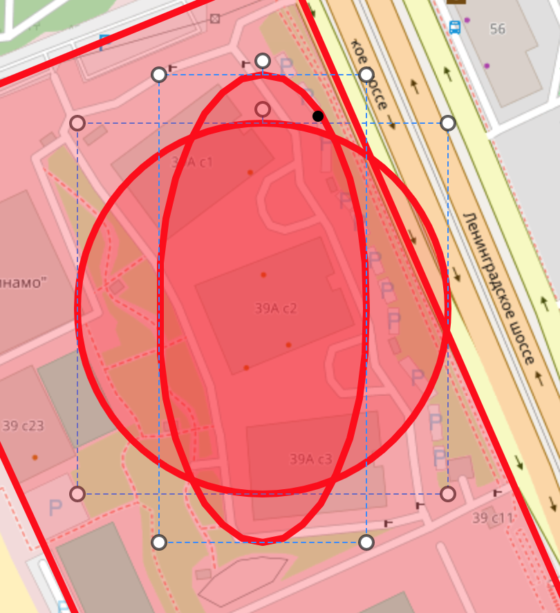
@stebogit just look at the attached pictures in #110 issue comments — there are also ovals instead of circles
artuska
on 20 Nov 2019
artuska
on 20 Nov 2019
@artuska first off, I believe you inverted the coords.
How do you create the polygons resulting in an oval?
stebogit
on 20 Nov 2019
@stebogit oh, ok, i got it — it is Turf who is using [lon, lat] coordinates, not geojson.io, well, it is fine.
How do you create the polygons resulting in an oval?
I do copy c.geometry.coordinates array of coordinates and then i create a Polygon on my Leaflet map with Leaflet.polygon method — this one is an ellipsis on the image above. Second circle is made with Leaflet.circle method and it looks like a circle :)
artuska
on 20 Nov 2019
Well it would be interesting to see what's the difference in there. However looks like it's not a @tirf/circle issue, but potentially somehow a conversion one? 🤔
stebogit
on 20 Nov 2019
@stebogit made a fiddle — https://jsfiddle.net/artuska/Lumgnz92/ — as you see, turfCirclePolygon does not have a circle shape.
artuska
on 20 Nov 2019
artuska
on 20 Nov 2019
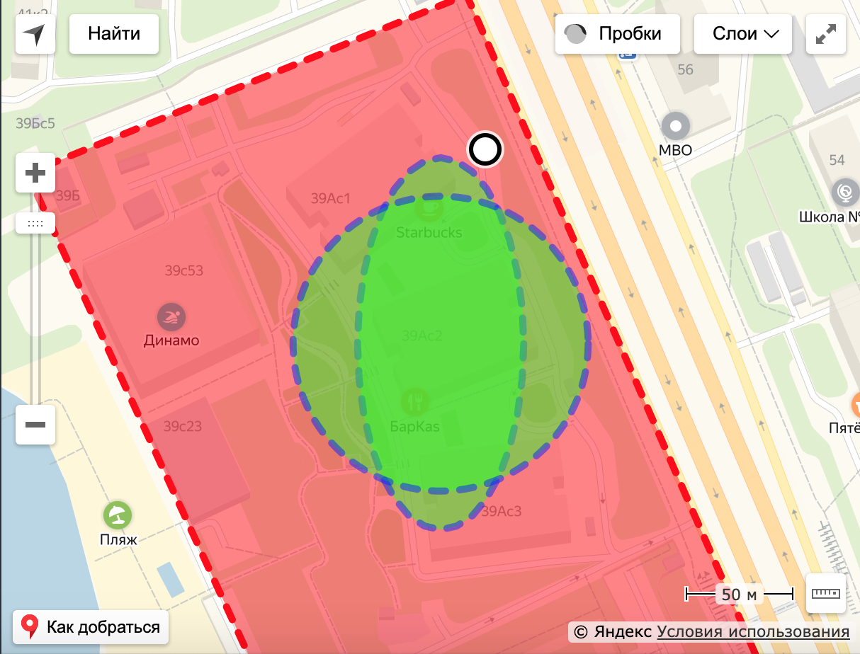
Well, the same ellipsis is on the Yandex.Maps... So, there is definitely a problem in Turf.
artuska
on 20 Nov 2019
var center = [
0,
0,
];
Well, this makes turf's circle round, not oval... but it is totally useless.
artuska
on 20 Nov 2019
OK @artuska I found the issue.
The data in Turf is definitely treated differently than in Leaflet (with all LatLgn stuff), the only common ground is GeoJSON.
If you try
var turfCircle = turf.circle([center[1], center[0]], radius / 1000, turfCircleOptions);
L.geoJSON(turfCircle).addTo(map);
that works beautifully.

The L.Polygon function does not work like @turf/helpers|polygon. You need to use the L.geoJSON method on the GeoJSON output of Turf circle.
stebogit
on 21 Nov 2019
But anyway — my geometry appears as a circle in Syria but as an ellipsis in Moscow — this is totally strange.
Have you checked the projection system of your project?
MapBox use EPSG 3857, this SR amplify the deformation in data as you move away from equator. Then given that Syria is nearest equator than Moscow you see there a circle and an ellipse in Moscow.
 MaxDragonheart
on 22 Nov 2019
MaxDragonheart
on 22 Nov 2019
Did you find a fix for this? What map provider you use is irrelevant, when you plot the returned coordinates, you get an ellipse.
 doylemark
on 15 Apr 2020
doylemark
on 15 Apr 2020
@doyle-mark looks like there is nothnig wrong here, provided you use the expected order of the elements of the coordinates array (specifically [lng, lat])
stebogit
on 16 Apr 2020
Any one solved the problem of the oval buffer?
 omar-alnayme
on 28 Sep 2020
omar-alnayme
on 28 Sep 2020
Related issues
 andrewharvey
·
3Comments
andrewharvey
·
3Comments
 morganherlocker
·
5Comments
morganherlocker
·
5Comments
 dhivehi
·
5Comments
dhivehi
·
5Comments
 nkint
·
4Comments
nkint
·
4Comments
 valeriik
·
4Comments
valeriik
·
4Comments
Most helpful comment
OK @artuska I found the issue.
The data in Turf is definitely treated differently than in Leaflet (with all
LatLgnstuff), the only common ground is GeoJSON.If you try
that works beautifully.
The
L.Polygonfunction does not work like@turf/helpers|polygon. You need to use theL.geoJSONmethod on the GeoJSON output of Turf circle.