Streetcomplete: Consider parallel ways in Bicycle quest
Hello.
The bicycle quest apparently only considers each way individually. However in many cases cycleways or shared busways are mapped as a separate way. This results in users creating wrong data, such as adding a cycle track where it as already been mapped.
Example with this share_busway : https://www.openstreetmap.org/changeset/63789825
Is it possible to improve the quest to consider parallel ways ?
Regards,
Antoine.
 naomap
All 10 comments
image of the street in street view: https://www.google.pl/maps/@48.8646259,2.3553856,3a,75y,20.25h,79.17t/data=!3m5!1e1!3m3!1sqlJCEGY7sQ_coObV8XI25g!2e0!6s%2F%2Fgeo2.ggpht.com%2Fcbk%3Fpanoid%3DqlJCEGY7sQ_coObV8XI25g%26output%3Dthumbnail%26cb_client%3Dmaps_sv.tactile.gps%26thumb%3D2%26w%3D203%26h%3D100%26yaw%3D82.73496%26pitch%3D0%26thumbfov%3D100
 matkoniecz
on 31 Oct 2018
matkoniecz
on 31 Oct 2018
You didn't get my point. Yes there is a busway, but it is ALREADY mapped as https://www.openstreetmap.org/way/55129128
So adding the tag cycleway:right to https://www.openstreetmap.org/way/55129129 is wrong.
In fact the quest should NOT ask whether there is a cycleway or shared busway on the right in this case, as it is already mapped as a separate way.
naomap
on 31 Oct 2018
You didn't get my point.
Why you thought so? How I should avoid such misunderstanding in a future? I found photos of the affected location (to check whatever current tagging is correct), noticed that it is viable to tag is this way. I just left it as a note to save time of others.
I added nothing more as I had no additional useful content to post.
matkoniecz
on 31 Oct 2018
The problem in that sort of case (this is not the only occurrence of course), is that StreetComplete creates redundant data. In fact no, this is not redundant data but wrong data. Having an highway with a tag cycleway:right=share_busway PLUS a parallel way on its right carrying the tags psv=yes and bicyle=yes means that there are two parallel cycle routes whereas there is only one !
naomap
on 31 Oct 2018
I think the problem here is not StreetComplete, it was simply a wrong entry made by that user. He should have answered that there is no cycleway. The map is displayed in StreetComplete, both the bus lane part of the road and the other road.
The map looks like this:
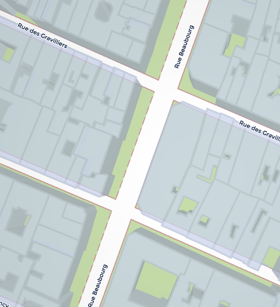
However, one can see that it is not very clear that there are two roads parallel to each other displayed here (current version of StreetComplete doesn't even show the bus lane with a dashed outline) because the roads melt into each other just like the Mapnik map on openstreetmap.org on zoom level 18 and below or for example the several lanes of a motorway on lower zoom levels.
I venture to say that two roads are so close to each other is somewhat of an exception (in reality, it is one road, only it is not mapped that was in OSM), but still, do you have a suggestion how to make it more clear to users of the app that there are two ways and the user should only answer the question for the way highlighted?
 westnordost
on 1 Nov 2018
westnordost
on 1 Nov 2018
do you have a suggestion how to make it more clear to users of the app that there are two ways and the user should only answer the question for the way highlighted?
Allow higher zoom in the map style? Make roads in map style narrower to reduce merging problem?
matkoniecz
on 1 Nov 2018
Going into this direction, maybe derive the final rendered width in meters (at high zoom levels) from width or lanes, if possible.
westnordost
on 1 Nov 2018
Apologies for the late reply, I was off for a few days.
I kind of agree that in many such cases the street and bus lane might better be mapped as a single way. However we cannot rely on this because of different practices. The rendering should of course make the best to show what's already mapped, however I realize it is far from easy to consider all cases.
I just came across the tag cycleway=separate (https://wiki.openstreetmap.org/wiki/Key:cycleway#Other_values), which is meant to be added to roads where the cycleway is mapped as a separate way. This is not widely used yet, however maybe SC could check whether the way holds this tag before requesting the user whether there is some cycleway. Maybe it does already ?
This approach is debatable as this means adding a tag to help a contribution tool, however this looks like a pragmatic approach...
naomap
on 6 Nov 2018
This is not widely used yet, however maybe SC could check whether the way holds this tag before requesting the user whether there is some cycleway. Maybe it does already ?
Yes, it does. In fact, if the road is tagged with any cycleway value, the cycleway is not asked. See here for the whole Overpass query:
westnordost
on 6 Nov 2018
Alright, so apart of what is already in place, the only things that I can think of that can further mitigate the issue (of not being clear which road-way exactly the user is asked) is to show the road-way in its actual width, if the information is available. I created a ticket for that: https://github.com/ENT8R/streetcomplete-mapstyle/issues/65
Another thing that maybe would mitigate the issue is to (optionally) show a satellite image as background and not the OSM. But there is also a ticket for that.
Thus, I will close this ticket.
westnordost
on 9 Nov 2018
Related issues
 JulienPalard
·
3Comments
JulienPalard
·
3Comments
 monikarora
·
3Comments
westnordost
·
3Comments
monikarora
·
3Comments
westnordost
·
3Comments
 RubenKelevra
·
3Comments
RubenKelevra
·
3Comments
 lzmartinico
·
4Comments
lzmartinico
·
4Comments
Most helpful comment
Why you thought so? How I should avoid such misunderstanding in a future? I found photos of the affected location (to check whatever current tagging is correct), noticed that it is viable to tag is this way. I just left it as a note to save time of others.
I added nothing more as I had no additional useful content to post.