Openstreetmap-website: The comma in the Swedish coordinate format should be a period
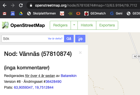
In the Swedish version of https://www.openstreetmap.org/ , coordinates are erroneously displayed with a comma instead of a period. This makes some other programs – for instance Gramps – unable to handle coordinate values that are copied from the Swedish version of the site.
(Note that in Sweden/Swedish, the decimal separator is still a comma instead of a period. For example, the American number 1,000.50 is in Sweden/Swedish written as 1.000,50 or 1 000,50 or 1000,50. I guess this is the source of the comma/period error.)
 zhouhana
All 6 comments
There's a very old trac ticket requesting the same for the German translation: https://trac.openstreetmap.org/ticket/5082 ("Coordinate display for node browe pages: Decimal separator should not be translated").
I think it would probably be best not to translate those coordinates values at all.
 mmd-osm
on 25 Jul 2020
mmd-osm
on 25 Jul 2020
Well I think we need to understand the issue first - the fact that another program can't parse it isn't in itself evidence that we are wrong, and I say that as a Gramps user myself...
If I understand correctly the claim being made is that, despite numbers generally being written with a comma as the decimal separator, for coordinates the decimal point is normally used, at least in Swedish and German? Does this hold more widely for other european countries that would normally use comma?
Or is the problem here that we'd using comma both as the decimal point and to separate the coordinates, thereby confusing programs like Gramps that try to parse a coordinate pair?
 tomhughes
on 26 Jul 2020
tomhughes
on 26 Jul 2020
for coordinates the decimal point is normally used, at least in Swedish and German?
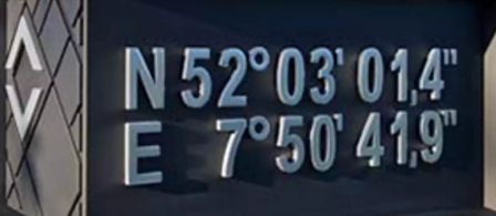
Not in the normal environment. See here an example of an coordinate at a residential house:
 ...
...
Or is the problem here that we'd using comma both as the decimal point and to separate the coordinates, thereby confusing programs like Gramps that try to parse a coordinate pair?
... but in the computer environment you find more software products which does not support the three commas.
 HolgerJeromin
on 26 Jul 2020
HolgerJeromin
on 26 Jul 2020
ISO 6709 “Standard representation of geographic point location by coordinates is the international standard for representation of latitude, longitude and altitude for geographic point locations.” mentions:
_The decimal point is a part of the value, thus must usually be configured by the operating system_
So this ISO norm might be a good indication about a globally accepted format.
mmd-osm
on 26 Jul 2020
Comma is also used for decimal point in Danish locale, as in Swedish, and as a native Danish speaker I find this formatting to be correct.
I interpret the latitude and longitude as two separate decimal values which should by themselves be formatted according to the locale in use. The separator between the latitude and longitude could be discussed, however.
The comma+space separation of a list's items (", ") used in OSM (and not localisable at the moment) is also mostly used in textual Danish writing, according to this older discussion among engineers, and allegedly, follows official writing rules (haven't been able to verify that though).
With a heavy mathematically inclined backpack I could also see the list items separated by a semicolon (and maybe enclosed in parentheses). In Danish semicolon is often used when referring to points in a coordinate system with decimal values, I found some hints that this is also common in Swedish. The unicode defintion also has the semicolon defined for the 'symbols.list' entry, I am however not very familiar with the unicode details so wouldn't know how that entry is precisely meant to be used.
For the node 57810874 in question a semicolon separator used in Swedish, to compare with the screenshot, would become: "Plats: 63,9059347; 19,7512844", which to my eyes is preferable.
This coordinate formatting is probably only meant for humans to read. Maybe the people wanting to be able copy a structured and standardised coordinate from an object could be satisfied by also placing a geo URI formatted coordinate on the page?
Google Maps has btw. given up on this and, at least for input, only accepts decimal degress formatted using English locale;
- English: "Use periods as decimals, not commas. Incorrect: 41,40338, 2,17403. Correct: 41.40338, 2.17403. " (Find or enter latitude & longitude)
- Danish: "Brug punktummer som decimaler, ikke kommaer. Forkert: 41,40338, 2,17403. Rigtigt: 41.40338, 2.17403." (Find eller indtast længde- og breddegrad)
- Swedish: "Använd punkter som decimaler, inte kommatecken. Fel: 41,40338, 2,17403. Rätt: 41.40338, 2.17403." (Hitta eller ange latitud och longitud)
 mikini
on 13 Aug 2020
mikini
on 13 Aug 2020
Thanks for your comments regarding this issue. I realise that the comma would actually be more in line with Swedish locale, but I also think that whenever (and wherever) coordinates are specified they are first and foremost provided as data to be treated by computer systems, and/or are an output from such systems. You wouldn't remember and write coordinates in a text only meant to be read by humans. So I think that Google Maps made the right decision here.
zhouhana
on 14 Aug 2020
Related issues
 kgreenek
·
6Comments
kgreenek
·
6Comments
 Zverik
·
3Comments
Zverik
·
3Comments
 tyrasd
·
5Comments
tyrasd
·
5Comments
 jidanni
·
5Comments
jidanni
·
5Comments
 warmwater
·
5Comments
warmwater
·
5Comments
Most helpful comment
There's a very old trac ticket requesting the same for the German translation: https://trac.openstreetmap.org/ticket/5082 ("Coordinate display for node browe pages: Decimal separator should not be translated").
I think it would probably be best not to translate those coordinates values at all.