Openstreetmap-carto: Add rendering for landuse=logging
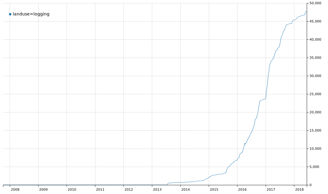
23 787 uses already and has a wiki page. I think it should be rendered the same as landuse=industrial, since logging is clearly related to wood industry.
 kocio-pl
All 35 comments
sent from a phone
On 3 Jan 2017, at 03:34, kocio-pl notifications@github.com wrote:
23 787 uses already and has a wiki page. I think it should be rendered the same as landuse=industrial, since logging is clearly related to wood industry.
-1, I would rather render it like forest, maybe like farmland but definitely not like industrial
 dieterdreist
on 3 Jan 2017
dieterdreist
on 3 Jan 2017
I was also thinking about industrial background + tree pattern. Forest rendering makes little sense, since they are mostly inside the forest (so we have no white spaces, but we're effectively not able to recognize them), and I guess farmland is rather for growing than cutting.
kocio-pl
on 3 Jan 2017
This seems to only be used in Russia and parts of Eastern Europe.
 pnorman
on 4 Jan 2017
pnorman
on 4 Jan 2017
2017-01-04 10:12 GMT+01:00 Paul Norman notifications@github.com:
This seems to only be used in Russia and parts of Eastern Europe.
to me this tag has a lot of problems and it seems to require a subtag
"logging":
https://wiki.openstreetmap.org/wiki/Tag:landuse%3Dlogging
This wikipage is substandard and likely would not have passed our standard
proceduce for tag development (proposal process) in this form.
from the wiki:
"Describes logging areas. For the natural or intentional reforestation
areas may be used in combination with natural
https://wiki.openstreetmap.org/wiki/Key:natural=scrub
https://wiki.openstreetmap.org/wiki/Tag:natural%3Dscrub. "
--> scrub explicitly is not for forest areas (which would be both,
"intentional" and "natural reforestation" )
from the wiki:
"Additional tags:
- logging
https://wiki.openstreetmap.org/w/index.php?title=Key:logging&action=edit&redlink=1
=clearcutting
https://wiki.openstreetmap.org/w/index.php?title=Tag:logging%3Dclearcutting&action=edit&redlink=1 - all trees in an area are uniformly cut down;
- logging
https://wiki.openstreetmap.org/w/index.php?title=Key:logging&action=edit&redlink=1
=selective_cutting
https://wiki.openstreetmap.org/w/index.php?title=Tag:logging%3Dselective_cutting&action=edit&redlink=1 - only some trees in an area are cut down (for example, sanitation cutting);
- logging:start_date
https://wiki.openstreetmap.org/w/index.php?title=Key:logging:start_date&action=edit&redlink=1
=* - logging date (using the format yyyy-mm-dd)."
as the logging will likely be done in a short time frame, this tag will
soon have to be removed again in case of "clearcutting", while "selective
cutting" implies the forest to remain (i.e. the tag is not chosen well,
because incompatible with landuse=forest).
Generally, the most significant information of this tag seems to be able to
add a "logging:start_date", while landuse=forest already implies
landuse=logging (at some point in time).
-1 for supporting this tag, it is incompatible with the rest of the tagging
scheme and its usage should be discouraged.
dieterdreist
on 4 Jan 2017
That is not necessarily a problem IMO (considering the non-uniform distribution of woodlands and the non-uniform distribution of community interest in those globally). But the tag is very vague at the moment, in a wide sense it could be used for any secondary woodlands (which have been cut down at some point in the past) that are currently used for wood production - which would apply to at least 2/3 of all woodlands in Germany for example. We would need to consider if we actually want to render that in this style.
I would prefer to concentrate on rendering physical properties like leaf_type/leaf_cycle and possibly secondary vegetation layers (should we ever have a tagging scheme established for that).
 imagico
on 4 Jan 2017
imagico
on 4 Jan 2017
2017-01-04 10:49 GMT+01:00 Christoph Hormann notifications@github.com:
That is not necessarily a problem IMO (considering the non-uniform
distribution of woodlands and the non-uniform distribution of community
interest in those globally). But the tag is very vague at the moment, in a
wide sense it could be used for any secondary woodlands (which have been
cut down at some point in the past) that are currently used for wood
production
+1
IMHO this should become/remain a property "logging" to indicate if and how
logging occurs. No need to also add "landuse=logging", "logging" is not a
landuse, or it is for very short time in places that are the rest of the
time forests.
dieterdreist
on 4 Jan 2017
That is not necessarily a problem IMO (considering the non-uniform distribution of woodlands and the non-uniform distribution of community interest in those globally).
Ya, but I'd expect something in North America, Western Europe, or anywhere but those two areas.
I would prefer to concentrate on rendering physical properties like leaf_type/leaf_cycle and possibly secondary vegetation layers (should we ever have a tagging scheme established for that).
Yes, I worry that this would take valuable cartographic space, which would make additional tree detail harder.
pnorman
on 4 Jan 2017
The tag describes a part of the forestry life-cycle, and as such it conflicts with landuse=forest. As a forest life-cycle is longer than e.g. on farmland, a sub-tagging would make sense.
Thus I disagree with rendering the tag as it is.
 polarbearing
on 4 Jan 2017
polarbearing
on 4 Jan 2017
The tag describes a part of the forestry life-cycle, and as such it conflicts with landuse=forest. As a forest life-cycle is longer than e.g. on farmland, a sub-tagging would make sense.
Thanks, this sounds right for me - it needs some discussion on Tagging list how it should be done properly. It's interesting to me however what type of landuse will be here after the logging is done - scrub does not look like analogy to a brownfield.
kocio-pl
on 4 Jan 2017
what type of landuse will be here after
That probably depends on the intentions and the sustainability. If it's scheduled for construction, I'd tag greenfield (not brownfield, no previous construction demolished). If trees are planted, it's young forest. If it's left alone and nature cannot take over, soil may erode, and you are left with a desert or bare rock.
polarbearing
on 4 Jan 2017
The most interesting case for me is when the ground is left on the surface and even no grass is here. We render it as land by default and it's sane, but I wonder how to tag this kind of area. It's not necessary a problem of the logging - this also what I found in the city sometimes. But I digress.
kocio-pl
on 4 Jan 2017
2017-01-04 17:03 GMT+01:00 kocio-pl notifications@github.com:
this also what I found in the city sometimes
what you find in the city is completely different to the situation (e.g.
soil) you will get after logging a forest.
dieterdreist
on 4 Jan 2017
This tag is still raising, maybe some Tagging mailing list discussion should be resurrected to decide what to do with that wiki page:
https://wiki.openstreetmap.org/wiki/Tag%3Alanduse%3Dlogging
kocio-pl
on 27 Sep 2018
The main difference between landuse=logging vs landuse=forest is that in Russia, unfortunately, not all loggings are restored with new trees. The common case is to clear cut the wood, wait about 5 - 10 years and then start using it as a residential area. And in this 5 - 10 year period this area is still registered as a wood.
 ghost07tula
on 27 Sep 2018
ghost07tula
on 27 Sep 2018
@ghost07tula, its same way in California. There's a bunch of square spots in northern California that are tagged as landus=forest due to being used for logging, but they never grew trees back there for whatever reason after they were chopped down. So its just patches of ground that are rendered as trees now when they shouldn't be. Its still considered managed logging areas though.
 Adamant36
on 27 Sep 2018
Adamant36
on 27 Sep 2018
My understanding is that it is no longer a forest there and it should be excluded from this area. Maybe this note should be added to the wiki page.
kocio-pl
on 27 Sep 2018
For some period of time (up to 10 years) you don't know whether the forest will be restored in this area, or it will be formally excluded from it. Landuse=logging is exactly for this case
ghost07tula
on 27 Sep 2018
This is exactly why I think such area should be excluded from the forest and probably tagged as logging. It should be clear then why this is excluded. When the forest is back (or whatever else), it should be tagged accordingly.
kocio-pl
on 27 Sep 2018
Makes sense. So the correct way would be to tag logging as landuse=logging and exclude it from the forest, right? Then we face the question about logging rendering again.
ghost07tula
on 27 Sep 2018
I reopen the ticket to show that the problem is discussed again.
Hm, it is similar to brownfield. Maybe something similar would make sense anyway.
kocio-pl
on 27 Sep 2018
Brownfield with the forest pattern maybe?
Adamant36
on 27 Sep 2018
Makes sense for me. Could you test that?
kocio-pl
on 27 Sep 2018
Are we certain that this tag landuse=logging is only used for areas devoid
of trees?
Might it be used as a synonym for landuse=forest in the sense of “land used
for growing trees which will be cut down for wood/lumber in the future?”
The wiki page suggests that it may be an area of “selective logging” where
only some trees have been cut: “logging=selective_cutting - only some trees
in an area are cut down (for example, sanitation cutting);”
Someone should submit a proposal for this tag to define it better.
On Thu, Sep 27, 2018 at 7:34 PM Adamant36 notifications@github.com wrote:
Brownfield with the forest pattern maybe?
—
You are receiving this because you are subscribed to this thread.
Reply to this email directly, view it on GitHub
https://github.com/gravitystorm/openstreetmap-carto/issues/2531#issuecomment-425042122,
or mute the thread
https://github.com/notifications/unsubscribe-auth/AoxshHetlpoe_IoTQbgOr8Z8YyQIgfPCks5ufKnPgaJpZM4LZTPM
.
 jeisenbe
on 27 Sep 2018
jeisenbe
on 27 Sep 2018
Sure. I can add it the list and give it a try. I've been wanting to learn how to do the code for rendering patterns.
Adamant36
on 27 Sep 2018
@jeisenbe Would you like to take care of discussing this problem on Tagging list?
kocio-pl
on 27 Sep 2018
Sorry, I’ve already got 2 proposals in the RFC stage, and I don’t know if
any examples of this tag in the areas where I map.
Dimitry, would you be willing to send an email to the tagging mailing list
about this?
On Thu, Sep 27, 2018 at 7:47 PM kocio-pl notifications@github.com wrote:
@jeisenbe https://github.com/jeisenbe Would you like to take care of
discussing this problem on Tagging list?—
You are receiving this because you were mentioned.Reply to this email directly, view it on GitHub
https://github.com/gravitystorm/openstreetmap-carto/issues/2531#issuecomment-425045168,
or mute the thread
https://github.com/notifications/unsubscribe-auth/AoxshK7dXFqI8izyJ4DmjJdEhrhvh4Zdks5ufKyrgaJpZM4LZTPM
.
jeisenbe
on 27 Sep 2018
Sure. Just kindly point me the address, who should I CC and tell me a couple of words about the process for this.
ghost07tula
on 27 Sep 2018
Logging=clearcutting has 2016 uses and logging=selective_cutting only has 175 uses. In case it makes a difference. To me that makes it seem like the tag is mostly used for clear cut areas. Plus, that's what the picture on the side shows. Instead of brownfield rendering we could always go with landuse=construction with tree pattern though. Maybe it would fit better. Or if nothing else, industrial with tree pattern. Also, it says the tag can be combined with scrub. If it was meant at all for still forested areas, I doubt scrub would work with it.
Adamant36
on 27 Sep 2018
@ghost07tula Great! You just need to register here:
https://lists.openstreetmap.org/listinfo/tagging
Then you simply write to the list address and everybody else get their copy (and the archive is created along the way).
kocio-pl
on 27 Sep 2018
Good info. So both are pretty rare compared to the large number of uses of
the main tag.
On Thu, Sep 27, 2018 at 7:59 PM Adamant36 notifications@github.com wrote:
Logging=clearcutting has 2016 uses and logging=selective_cutting only has
175 uses. In case it makes a difference. To me that makes it seem like its
mostly used for clear cut areas. Plus, that's what the picture on the side
shows. Instead of brownfield rendering we could always go with
landuse=construction with tree pattern though. Maybe it would fit better.
Or if nothing else, industrial with tree pattern. Also, it says the tag can
be combined with scrub. If it was meant at all for still forested areas, I
doubt scrub would work with it.—
You are receiving this because you were mentioned.
Reply to this email directly, view it on GitHub
https://github.com/gravitystorm/openstreetmap-carto/issues/2531#issuecomment-425048951,
or mute the thread
https://github.com/notifications/unsubscribe-auth/AoxshN4rifK0pjlArR1-lvLYkFYU3VnIks5ufK-qgaJpZM4LZTPM
.
jeisenbe
on 27 Sep 2018
Am Do., 27. Sep. 2018 um 10:39 Uhr schrieb Adamant36 <
[email protected]>:
@ghost07tula https://github.com/ghost07tula, its same way in
California. There's a bunch of square spots in northern California that are
tagged as landus=forest due to being used for logging, but they never grew
trees back there for whatever reason. So just patches of ground that are
rendered as trees when they shouldn't be. Its still considered managed
logging forest though.
no, in osm, these areas are not considered landuse=forest, because they are
_not covered with trees_. It doesn't matter how they are legally
classified, all that matters for OSM is how they are actually used.
For me, "landuse=logging" for cut down areas seems semantically
problematic. "landuse=logging" is semantically describing that the area is
currently logged. Shouldn't this be "logged"?
dieterdreist
on 1 Oct 2018
I've been using man_made=clearcut + natural=scrub as recommended on the man_made=clearcut wiki page.
It seems to me that natural=scrub is an apt description for these recently-logged areas, and the rendering also looks great and understandable. It's true that these areas might be scrub only temporarily, but that also agrees with the wiki description: "[Scrub] may be the mature vegetation type in a particular region and remain stable over time, or a transitional community that occurs temporarily as the result of a disturbance, such as fire."
So I'd suggest we either:
- Simply render
landuse=loggingthe same way that we rendernatural=scrub(and probably do the same thing forman_made=clearcuttoo). - Don't render
landuse=loggingand encourage editors to addnatural=scrubin addition when they tag these features. The wiki page for landuse=logging already suggests this.
 almccon
on 1 Oct 2018
almccon
on 1 Oct 2018
I would add natural=scrub (if this is what is there now, even if
temporarily), and would not add man_made=clearcut (a tag that is not in
significant use and has neither been discussed nor proposed nor approved),
because the feature doesn't fit well under the "man_made" key.
dieterdreist
on 1 Oct 2018
I don't think natural=scrub would work because its for areas that have natural woody plant growth. Its not a given that the area left over from logging will contain that though. Some of them are just dirty areas, with maybe grass and left over logging tree waste. Tree waste doesn't count as scrub though. I don't think immature, replanted seedling trees count as scrub either. Its for a specific thing. Or, if scrub is there then add natural=scrub and landuse=logging. Because its the difference between landuse and land cover. It doesn't stop being logging land though just because the trees are chopped down.
Adamant36
on 2 Oct 2018
I don't see any clear solution here, so I close this ticket. Probably this area should be tagged with something more specific.
kocio-pl
on 1 Dec 2018
Related issues
 Vort
·
3Comments
Vort
·
3Comments
 wielandb
·
3Comments
wielandb
·
3Comments
 Tomasz-W
·
4Comments
polarbearing
·
5Comments
Tomasz-W
·
4Comments
polarbearing
·
5Comments
 HolgerJeromin
·
3Comments
HolgerJeromin
·
3Comments