Odm: Support for crop/canopy height calculation (DSM - DTM)
This is present in the lidar2dems code, should be fairly simple to implement by subtracting DTM from DSM. It was suggested on gitter.
 pierotofy
All 10 comments
@pierotofy
Point classification from RGB photos is a hard task.
I plan try lidar2dems. http://applied-geosolutions.github.io/lidar2dems/
I upload to my git a small urban area. 10 photos + LiDAR.
I have rural areas too. Some flight.
I hope it can be usefull for tests.
 yjmenezes
on 26 Jan 2018
yjmenezes
on 26 Jan 2018
@pierotofy thank you for your help and apologies for late gratitude.
@yjmenezes Thank you for your help. Can i make CHM out of the DSM and DTM images that are created not by using l2d? I want to get CHM from the outputs of WebODM? Is there any limitation while doing so?
 bipulneupane
on 30 Jan 2018
bipulneupane
on 30 Jan 2018
Hi @bipulneupane
As you, i am looking for .
I am note sure if @hobu PDAL has a filter to produce bare earth DTM from ODM point cloud (XYZ+RGB).
https://www.pdal.io/stages/filters.html
The problem is shown here:
https://rapidlasso.com/2015/09/21/creating-dtms-from-dense-matched-points-of-uav-imagery-from-senseflys-ebee/
I upload a LiDAR + RGB data set in a hope that someone could use it and help to make ODM even better. ODM is a great work. Thank you ODM developers.
yjmenezes
on 31 Jan 2018
@yjmenezes
Hi!
I wanted to know
- if it is always necessary to classify the point cloud first
- Error while density:
$ l2d_dems density georeferenced_model.las
Error creating density : No LAS files found
l2d_dems density completed (.) in 0:00:00.000208
I am getting error on the first step of classifying.
bipulneupane
on 8 Feb 2018
@bipulneupane
I think you must point the directory and not a las file.
l2d_dems density /path_to_las/
i have never used l2d_dems, i am sorry.
I think it's primary use
is for LiDAR data.
btw, I upload a LAS LiDAR dataset . It is not carefully classified but has all laser return pulses.
Class (2) would be bare earth.
https://github.com/yjmenezes/church_dataset
yjmenezes
on 8 Feb 2018
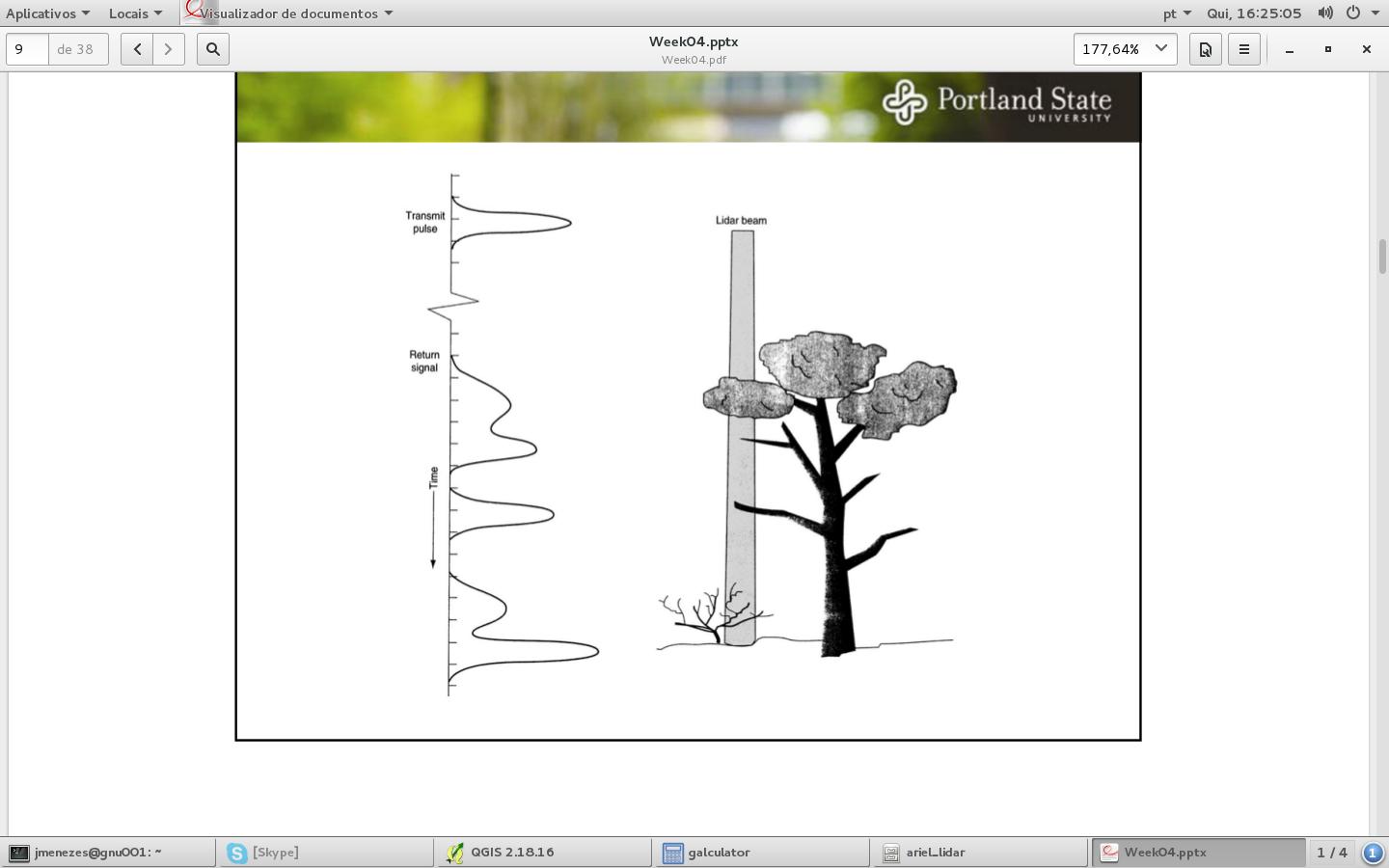
LiDAR data (like in the referenced diagram) includes an intensity value;
which is the response peaks on the graph. SfM PC will not have that
information.
To develop a CSM, you will need to develop a Ground Surface model, and then
use that to classify your point cloud, then calculate separation of those
surfaces.
On Thu, Feb 8, 2018 at 10:48 AM, julio cesar de menezes <
[email protected]> wrote:
@bipulneupane https://github.com/bipulneupane
I think you must point the directory and not a las file.
l2d_dems density /path_to_las/i have never used l2d_dems, i am sorry.
I think it's primary use
[image: lidar_las]
https://user-images.githubusercontent.com/4775645/35991794-77611dce-0cef-11e8-8970-bc2209398810.png
is for LiDAR data.btw, I upload a LAS LiDAR dataset . It is not carefully classified but has
all laser return pulses.
Class (2) would be bare earth.
https://github.com/yjmenezes/church_dataset—
You are receiving this because you are subscribed to this thread.
Reply to this email directly, view it on GitHub
https://github.com/OpenDroneMap/OpenDroneMap/issues/752#issuecomment-364210327,
or mute the thread
https://github.com/notifications/unsubscribe-auth/AFOkJZmaK5o1I5Nv5nihM4z2idBLkuaWks5tS0F4gaJpZM4RuU3H
.
--
Daryl Van Dyke
GIS Analyst
Klamath Strategic Habitat Conservation Team
US Fish & Wildlife Service - AFWO, R8
(707) 825-5153
https://github.com/GeospatialDaryl
 GeospatialDaryl
on 8 Feb 2018
GeospatialDaryl
on 8 Feb 2018
I can see this being implemented as a contrib/ module
 dakotabenjamin
on 17 Mar 2018
dakotabenjamin
on 17 Mar 2018
Here you can find Python code using PDAL (probably it should be updated) to calculate CHM from input LAS file and DTM.
Do you think could be useful? I could help to adapt to OpenDroneMap with some suggestions
 lucadelu
on 14 Apr 2018
lucadelu
on 14 Apr 2018
@lucadelu that would be super-useful! Here's some things that stand out to me:
- PDAL code will need to use JSON, not XML (as XML is being phased out in PDAL)
- I would explore to see if it would be better to calculate the CHM based on the existing rasters (DSM and DTM) rather than using PDAL's python filter. Just a thought.
pierotofy
on 15 Apr 2018
@pierotofy thanks for your answer, yes we should use to use JSON, this was old code..
About CHM calculation we could have several way to calculate:
- from existing rasters but at this point we could do this using existing software like GRASS GIS through mapcalc operation
- from an existing DTM and the calculated DSM from OpenDroneMap (still using GRASS GIS)
- from an existing DTM and the OpenDroneMap point cloud (using PDAL)
lucadelu
on 16 Apr 2018
Related issues
 JCAAUSFRA
·
5Comments
JCAAUSFRA
·
5Comments
 smathermather
·
5Comments
pierotofy
·
3Comments
smathermather
·
5Comments
pierotofy
·
3Comments
 syehorov
·
5Comments
pierotofy
·
4Comments
syehorov
·
5Comments
pierotofy
·
4Comments
Most helpful comment
LiDAR data (like in the referenced diagram) includes an intensity value;
which is the response peaks on the graph. SfM PC will not have that
information.
To develop a CSM, you will need to develop a Ground Surface model, and then
use that to classify your point cloud, then calculate separation of those
surfaces.
On Thu, Feb 8, 2018 at 10:48 AM, julio cesar de menezes <
[email protected]> wrote:
--
Daryl Van Dyke
GIS Analyst
Klamath Strategic Habitat Conservation Team
US Fish & Wildlife Service - AFWO, R8
(707) 825-5153
https://github.com/GeospatialDaryl