Mapsui: Point position : A to B with degrees
Hi,
I need to find position of the point B from the point A, where I know what the distance between them (meter) is, and the point B is from the point A in specific direction (degrees-clockwise).
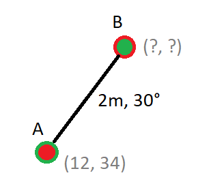
With analytic geometry (coordinate geometry) I'm trying to do:
Point positionA = new Point(12, 34);
Point positionB = null;//?
float distanceM = 2;//2m
int angle = 30;//30°

double distance1 = Math.Abs(Math.Sqrt(Math.Pow(positionB.X - positionA.X, 2) + Math.Pow(positionB.Y - positionA.Y, 2)));//Mapsui.Geometries.Utilities.Algorithms.Distance(positionA, positionB);
double angle1 = Math.Atan2((positionB.Y - positionA.Y) , (positionB.X - positionA.X)) * (180 / Math.PI);
//agle == agle1
tbc
How can I do it in Mapsui 1.4 (without too many of own calculations), any method/s?
I see this
Mapsui.Geometries.Utilities.Algorithms.RotateClockwiseDegrees but I'm not sure how (and if) I can use it. (and some calculations in GeoHelper)
Many Thanks,
Łukasz
 lukaszpitulski
All 15 comments
lukaszpitulski
on 26 Sep 2018
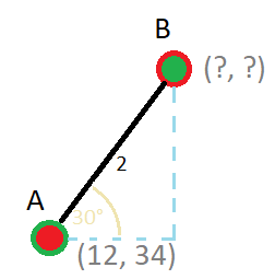
Pow(2) = Pow(Yb - 34)+Pow(Xb - 12); Tan(30) = (Yb - 34) / (Xb - 12); Atan(30) = (Xb - 12) / (Yb - 34) ... in this case is 30 so from my (on paper) calculation:
Xb = Sqrt(3) + 12; Yb = 35; B(14,35)
but is it correct and how calc it if will be different degrees?
I know maybe it's not Mapsui issue but will be nice to have some solution in Mapsui methods/algorithms.
lukaszpitulski
on 26 Sep 2018
Perhaps this could help you. See second answer.
 charlenni
on 26 Sep 2018
charlenni
on 26 Sep 2018
Yes, I've looked at the answer and... no idea what I'm doing here wrong, but it doesn't work:
            var startPoint = SphericalMercator.FromLonLat(19, 55);

            var pointA = new Feature { Geometry = startPoint };
            pointLayer.Add(pointA);

            var DegreesToRadians = Math.PI / 180;//0.01745329251994329576923690768489;//SphericalMercator.D2R
            var EarthRadius = 6378137.0;//SphericalMercator.Radius
            var TwoPi = Math.PI * 2;

            var rangeMeters = 2000;//2km
            var angle = 10;

            //var sp = SphericalMercator.ToLonLat(startPoint.X, startPoint.Y);
            var sp = startPoint.Clone();

            double lonA = sp.X;// * DegreesToRadians;
            double latA = sp.Y;// * DegreesToRadians;
            double angularDistance = rangeMeters / EarthRadius;
            double trueCourse = angle * DegreesToRadians;

            double lat = Math.Asin(
                Math.Sin(latA) * Math.Cos(angularDistance) +
                Math.Cos(latA) * Math.Sin(angularDistance) * Math.Cos(trueCourse));

            double dlon = Math.Atan2(
                Math.Sin(trueCourse) * Math.Sin(angularDistance) * Math.Cos(latA),
                Math.Cos(angularDistance) - Math.Sin(latA) * Math.Sin(lat));

            double lon = ((lonA + dlon + Math.PI) % TwoPi) - Math.PI;

            //var endPoint = SphericalMercator.FromLonLat(lon, lat);
            var endPoint = new Point(lon, lat);

            var pointB = new Feature { Geometry = endPoint };
            pointLayer.Add(pointB);
I've tried this and looks better but still distance and angle are wrong```
        var Longitude = 19;
        var Latitude = 54;

        var startPoint = SphericalMercator.FromLonLat(Longitude, Latitude);

        var pointA = new Feature { Geometry = startPoint };
        pointLayer.Add(pointA);

        var DegreesToRadians = Math.PI / 180;//0.01745329251994329576923690768489;//SphericalMercator.D2R
        var EarthRadius = 6378137.0;//SphericalMercator.Radius
        var TwoPi = Math.PI * 2;

        var rangeMeters = 200;
        var angle = 45;

        double lonA = Longitude * DegreesToRadians;
        double latA = Latitude * DegreesToRadians;
        double angularDistance = rangeMeters / EarthRadius;
        double trueCourse = angle * DegreesToRadians;

        double lat = Math.Asin(
            Math.Sin(latA) * Math.Cos(angularDistance) +
            Math.Cos(latA) * Math.Sin(angularDistance) * Math.Cos(trueCourse));

        double dlon = Math.Atan2(
            Math.Sin(trueCourse) * Math.Sin(angularDistance) * Math.Cos(latA),
            Math.Cos(angularDistance) - Math.Sin(latA) * Math.Sin(lat));

        double lon = ((lonA + dlon + Math.PI) % TwoPi) - Math.PI;

        var endPoint = SphericalMercator.FromLonLat(Longitude+lon, Latitude+lat);

        var pointB = new Feature { Geometry = endPoint };
        pointLayer.Add(pointB);
```
lukaszpitulski
on 26 Sep 2018
What means „wrong“? Be careful, it is a perhaps a problem same as the scale bar length.
charlenni
on 26 Sep 2018
I try be careful :)
I mean that the calculation (the distance and the direction) of the point B on the map are wrong (position B), should be like Point X (the image attached bellow).
Let me again explain using the initial example and analytic geometry (trigonometry).
Distance: 2° (not meters)
Angle: 30° (where I understand that: 0° = N, 90° = E, 180° = S, 270° W)
A(12, 34)
B(Xb, Yb)
Flat coordinate system:
Pow(2) = Pow(Yb - 34)+Pow(Xb - 12);
Tan(30) = (Yb - 34) / (Xb - 12);
Atan(30) = (Xb - 12) / (Yb - 34);
the result
Xb = Sqrt(3) + 12;
Yb = 35;
But pointB from on the map has (14.8262636, 34.433599).
I'm worry that the problem could be in SphericalMercator (OSM) and calculations for flat coordinate system(WGS84?), but in this case (dist:2°) the values are too small to have some calc. problems (big differences in result).
So, in the code (this) is something wrong.
I was hoping the Mapsui would help me.
The image of the map (OSM) and the points:
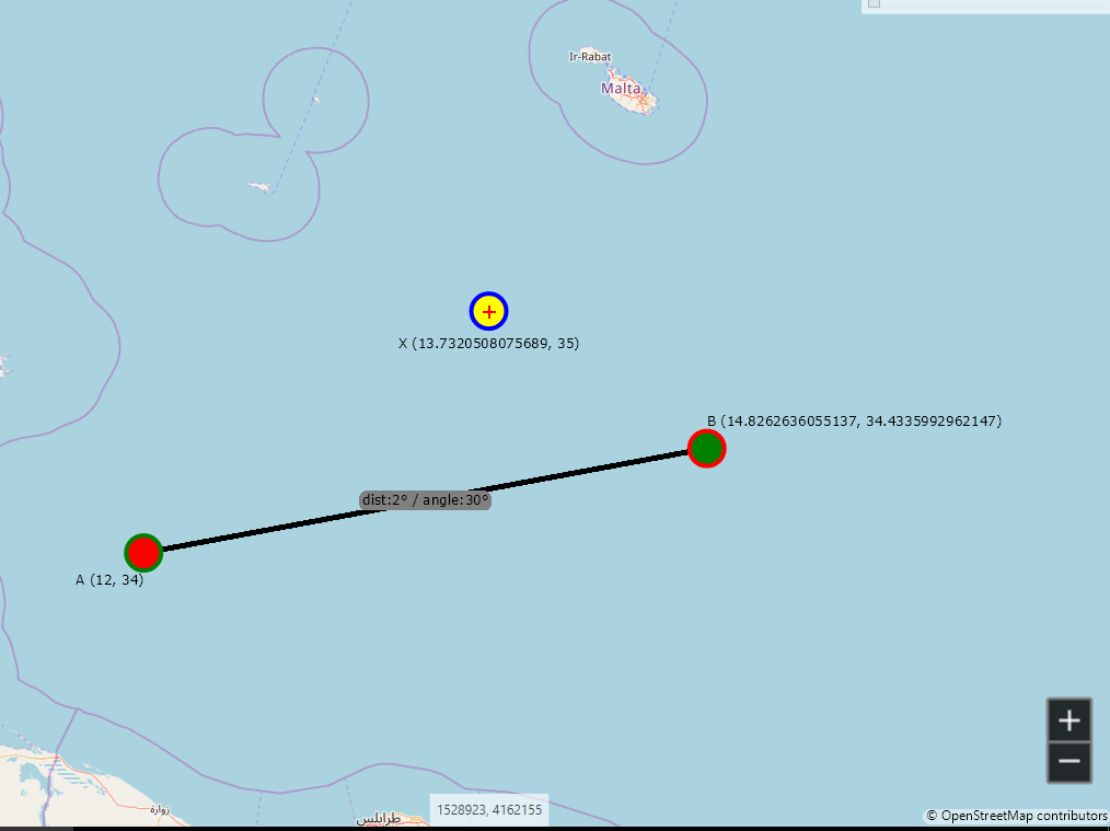
Now, the code looks:
            var Longitude = 12;
            var Latitude = 34;

            var startPoint = SphericalMercator.FromLonLat(Longitude, Latitude);

            StyleCollection stylesA = new StyleCollection
            {
                new VectorStyle{ Fill = new Brush(Color.Red), Outline = new Pen(Color.Green, 4) },
                new LabelStyle{ Text = "A ("+Longitude.ToString().Replace(",",".")+", "+Latitude.ToString().Replace(",",".")+")", BackColor = new Brush(Color.Transparent), HorizontalAlignment = LabelStyle.HorizontalAlignmentEnum.Right, Offset = new Offset(0,25, false) }
            };
            var pointA = new Feature { Geometry = startPoint, Styles = stylesA };
            pointLayer.Add(pointA);

            var DegreesToRadians = Math.PI / 180;//0.01745329251994329576923690768489;//SphericalMercator.D2R
            var EarthRadius = 6378137.0;//SphericalMercator.Radius
            var TwoPi = Math.PI * 2;

            var rangeMeters = 222393.344;//meters
            var angle = 30;//degrees

            double lonA = Longitude * DegreesToRadians;
            double latA = Latitude * DegreesToRadians;
            double angularDistance = 2;//rangeMeters / EarthRadius;
            double angularDistance2 = rangeMeters / 111196.672;
            double trueCourse = angle * DegreesToRadians;

            double lat = Math.Asin(
                Math.Sin(latA) * Math.Cos(angularDistance) +
                Math.Cos(latA) * Math.Sin(angularDistance) * Math.Cos(trueCourse));

            double dlon = Math.Atan2(
                Math.Sin(trueCourse) * Math.Sin(angularDistance) * Math.Cos(latA),
                Math.Cos(angularDistance) - Math.Sin(latA) * Math.Sin(lat));

            double lon = ((lonA + dlon + Math.PI) % TwoPi) - Math.PI;

            var endPoint = SphericalMercator.FromLonLat(Longitude+lon, Latitude+lat);

            StyleCollection stylesB = new StyleCollection
            {
                new VectorStyle{ Fill = new Brush(Color.Green), Outline = new Pen(Color.Red, 4) },
                new LabelStyle{ Text = "B ("+(Longitude+lon).ToString().Replace(",",".")+", "+(Latitude+lat).ToString().Replace(",",".")+")", BackColor = new Brush(Color.Transparent), HorizontalAlignment = LabelStyle.HorizontalAlignmentEnum.Left, Offset = new Offset(0,-25, false) }
            };
            var pointB = new Feature { Geometry = endPoint, Styles = stylesB };
            pointLayer.Add(pointB);


            var line = new LineString(new []{startPoint, endPoint});
            var lineAB = new Feature { Geometry = line, Styles = new StyleCollection{ new VectorStyle{ Line = new Pen(Color.Black, 5) }, new LabelStyle{ Text = String.Concat(/*rangeMeters, "m , ",*/"dist:",2,"° / angle:", angle, "° "), BackColor = new Brush(Color.Gray) } } };
            pointLayer.Add(lineAB);


            var thePoint = SphericalMercator.FromLonLat(Math.Sqrt(3)+12, 35);
            StyleCollection stylesX = new StyleCollection
            {
                new VectorStyle{ Fill = new Brush(Color.Yellow), Outline = new Pen(Color.Blue, 4) },
                new LabelStyle{ Text = "X ("+(Math.Sqrt(3)+12).ToString().Replace(",",".")+", "+(35).ToString().Replace(",",".")+")", BackColor = new Brush(Color.Transparent), Offset = new Offset(0,30, false) }
            };
            var pointX = new Feature { Geometry = thePoint, Styles = stylesX };
            pointLayer.Add(pointX);
To calculate distance your have to transform to WGS84 (EPGS:4326) and then calculate distance with a method that takes the shape of the earth into account. Maybe this (did a quick google) https://stackoverflow.com/a/24712129/85325
 pauldendulk
on 26 Sep 2018
pauldendulk
on 26 Sep 2018
I do I do but still can't get correct position of point B.
I'm checking at the provided link now, thanks.
lukaszpitulski
on 26 Sep 2018
Calculating the distance for lonlat points is a general thing. So there should be a lot of resources that can help you with that.
pauldendulk
on 26 Sep 2018
Yes, I look over some currently.
Please keep the issue open, I'll share the final solution, maybe it will be useful to someone and then I will close it.
lukaszpitulski
on 26 Sep 2018
What this RotateClockwiseDegrees(Double, Double, Double) is doing exactly?
"Rotates the specified point clockwise about the origin" - sorry, I don't get it. From algebra and linear function I thought that a point doesn't have any direction. (not as a line, which has a directional factor)
Am I wrong?
P1(12,34) -> RCD(12, 34, 90) = P2(34,-12)
P1(12,34) -> RCD(12, 34, 180) = P2(-12,-34)
P1(12,34) -> RCD(12, 34, 270) = P2(-34,12)
What's this for, when could it be useful?
P1(12,34) -> RCD(12, 34, 30) = P2(27.3923, 23.4448)
P1(12,34) -> RCD(12, 34, -30) = P2(-6.6076, 35.4448)
lukaszpitulski
on 27 Sep 2018
A point has no direction. The point is rotated relative to the origin. This logic is used when a geometry is rotated around it's center. Look at the Geomorpher. It is totally unrelated to calculating distance.
Did you try to the stackoverflow answer I pointed to?
pauldendulk
on 29 Sep 2018
@lukaszpitulski This is still open. Did you find the correct function? Are you still searching?
charlenni
on 17 Nov 2018
ooo yes, I've found the solution a few days after @pauldendulk post.
But if you have anything, any idea, please share it.
Unfortunately, till now I've not implemented this in the app.
I was very busy with others projects, which draws me away from that all the time.
If you wish I can share here what I have, or just close the issue.
lukaszpitulski
on 17 Nov 2018
Related issues
charlenni
·
3Comments
 willy40
·
6Comments
willy40
·
6Comments
 TarasParashchuk
·
4Comments
TarasParashchuk
·
4Comments
 Wil69
·
5Comments
lukaszpitulski
·
8Comments
Wil69
·
5Comments
lukaszpitulski
·
8Comments