Elasticsearch: Add Triangle and Hex Grid Encoding for GeoGridAggregator
A triangular tessellation based geo_point encoding supports aggregating on grids other than basic geohash (e.g., triangular, hex). These aggregations provide better spatial visualization but are also commonly used in GIS analysis applications due to their equal area characteristics. This feature issue adds a grid_type parameter to GeoHashGridParams (which will likely need to be refactored to GeoGridParams) to allow users to specify different grid types such as geohash, triangular, hexagonal. We should also investigate generalizing geohash_grid aggregation to a more general geo_grid aggregation so we can provide different grid definitions.
 nknize
All 15 comments
Is a solution for this still desired?
 djminkus
on 7 Feb 2017
djminkus
on 7 Feb 2017
Would this include also quad_keys, similar to Bing Maps (https://msdn.microsoft.com/en-us/library/bb259689.aspx)?
The tile-pyramids employed by most mapping services (Web Mercator, 2x2 division) are easier to work with from a front-end perspective than geohash-grids due to the uniform scaling horizontal/vertical across zoom levels.
So something like https://www.elastic.co/guide/en/elasticsearch/reference/current/search-aggregations-bucket-geohashgrid-aggregation.html, but bucketing by tile in the quad-tree.
 thomasneirynck
on 29 Mar 2017
thomasneirynck
on 29 Mar 2017
FWIW I got a user asking for this to me in person recently, the main motivation being to have equally-sized cells.
 jpountz
on 1 Feb 2018
jpountz
on 1 Feb 2018
Relates https://github.com/elastic/elasticsearch/issues/28121 - S2's cells are approximately rectangular and of approximately equal sizes.
 DaveCTurner
on 1 Feb 2018
DaveCTurner
on 1 Feb 2018
I just submitted a pull request #30231 with plus code support - I think that PR can be used as a step towards multi-hashing support.
 nyurik
on 29 Apr 2018
nyurik
on 29 Apr 2018
It would definitely be a good idea to support hexagonal partitioning.
See Uber's open-sourced h3 project (Hexagonal Hierarchical Geospatial Indexing System): https://github.com/uber/h3
Explanations with examples here: https://eng.uber.com/h3/
 consulthys
on 13 Dec 2018
consulthys
on 13 Dec 2018
Update here:
We should also investigate generalizing
geohash_gridaggregation to a more generalgeo_gridaggregation so we can provide different grid definitions.
Recently, changes were made to make geogrid aggregations really easy to create. This was done in favor of building one mega-geo-grid aggregation with different types due to concerns over overloading of the precision field, since precision means something different bucketing algorithm.
geotile_grid was introduced for support for web-xyz-tiling of geopoints.
 talevy
on 5 Feb 2019
talevy
on 5 Feb 2019
From a discussion, there is a geohex.net and a related
java port. Also, per @talevy above, i think we should update the issue's main description, e.g. summarize the changes required, benefits, and relevant libraries/specifications as individual sections to avoid digging through comments.
nyurik
on 14 Feb 2019
Hexagonal geo aggregation (Uber H3) support in ES would be a great feature, equal area buckets help with data visualization UX. Is it on roadmap?
 zakjan
on 9 Jun 2019
zakjan
on 9 Jun 2019
From @consulthys:
It would definitely be a good idea to support hexagonal partitioning.
See Uber's open-sourced h3 project (Hexagonal Hierarchical Geospatial Indexing System): https://github.com/uber/h3Explanations with examples here: https://eng.uber.com/h3/
From @zakjan:
Hexagonal geo aggregation (Uber H3) support in ES would be a great feature, equal area buckets > help with data visualization UX. Is it on roadmap?
For those who are interested, I've created an Ingest Processor plugin for generating H3 indexes at specified resolutions out of geo-location fields.
The repo is available here: https://github.com/consulthys/elasticsearch-ingest-h3
It works on Elastic Cloud as well!
consulthys
on 25 Oct 2019
@consulthys Looks promising, would you mind to include an example how to use it for search bucket aggregation? Similar to https://www.elastic.co/guide/en/elasticsearch/reference/current/search-aggregations-bucket-geohashgrid-aggregation.html
zakjan
on 25 Oct 2019
@zakjan
This is not possible yet. H3 indexes are just simple keywords, they have no meaning beyond that until that gets implemented into Elasticsearch (if ever).
All my plugin does is to create the H3 indexes out of a geo_point field.
I'm mainly using Kepler (https://kepler.gl/) for visualizing H3 indexes for now.
consulthys
on 25 Oct 2019
I did a bit of QGIS-based prototyping to see what it would actually look like as one would pan/zoom:
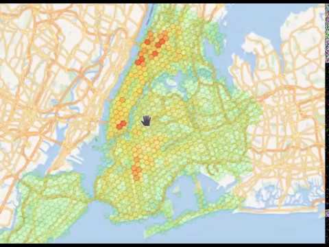
nyurik
on 19 Dec 2019
Nice @nyurik !!
You can also try it out live on https://www.tophap.com/ and see how it looks like ;-)

consulthys
on 19 Dec 2019
Thanks for the link! The site looks really nice. One of the primary reasons I did it is to see what it would look like on low zooms - how much of a tile warp would happen if someone attempted to analyze planet-scale data.
nyurik
on 19 Dec 2019
Related issues
 rpalsaxena
·
3Comments
rpalsaxena
·
3Comments
 ppf2
·
3Comments
ppf2
·
3Comments
 DhairyashilBhosale
·
3Comments
DhairyashilBhosale
·
3Comments
 abrahamduran
·
3Comments
abrahamduran
·
3Comments
 martijnvg
·
3Comments
martijnvg
·
3Comments
Most helpful comment
Hexagonal geo aggregation (Uber H3) support in ES would be a great feature, equal area buckets help with data visualization UX. Is it on roadmap?