Azure-docs: Get Navigable Lat and Long between two Units
[Enter feedback here]
This is not an issue but a query-
Is there an API or methodology available to get navigable lat and longs between two units, that can be used to draw a navigation line between the two points?
Expectation:
For now, I have hardcoded the points to get the expected result:
Document Details
⚠ Do not edit this section. It is required for docs.microsoft.com ➟ GitHub issue linking.
- ID: fa6d4f33-0311-2315-edef-b81c06fb3e0d
- Version Independent ID: f7cc6c67-470f-e3f2-1a5c-d71487a85034
- Content: Use Creator to create indoor maps
- Content Source: articles/azure-maps/tutorial-creator-indoor-maps.md
- Service: azure-maps
- GitHub Login: @anastasia-ms
- Microsoft Alias: v-stharr
 Druffl3
All 15 comments
Hello @Druffl3 Thanks for reaching out to us, we will update you soon on this.
 SatishBoddu-MSFT
on 28 Jul 2020
SatishBoddu-MSFT
on 28 Jul 2020
Currently, there is no way to retrieve lat/lon values for a specific unit within a facility. I have inquired as to whether or not this feature will be included or considered in the future. I will let you know when I hear from the project manager.
 anastasia-ms
on 28 Jul 2020
anastasia-ms
on 28 Jul 2020
Thanks for responding @anastasia-ms . There's an API in Point number 4 here: https://docs.microsoft.com/en-us/azure/azure-maps/tutorial-creator-indoor-maps#query-datasets-with-wfs-api , that actually provides us with lat and longs for units in the 'coordinates' tag. And here's a sample of it:
{
            "type": "Feature",
            "geometry": {
                "type": "Polygon",
                "coordinates": [
                    [
                        [
                            77.619268203272185,
                            13.045423111699277
                        ],
                        [
                            77.619332721784943,
                            13.045423111594745
                        ],
                        [
                            77.619332721899752,
                            13.045486366993508
                        ],
                        [
                            77.619268203370609,
                            13.045486367098038
                        ],
                        [
                            77.619268203272185,
                            13.045423111699277
                        ]
                    ]
                ]
            },
            "properties": {
                "originalId": "2fa3d39f-9b0b-4ed2-84e0-20488d8031a8",
                "categoryId": "CTG8",
                "isOpenArea": true,
                "isRoutable": true,
                "routeThroughBehavior": "allowed",
                "levelId": "LVL14",
                "occupants": [],
                "addressId": "DIR1",
                "name": "154"
            },
            "id": "UNIT26",
            "featureType": ""
        }
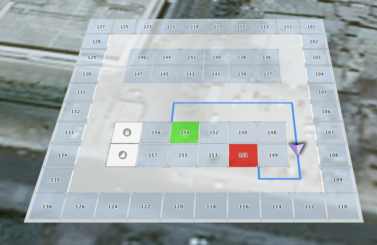
Wouldn't this be the coordinates of UNIT26? Based on this information only I could pick out relevant coordinates and offset it by some value, so that while drawing, the lines don't cut through the map (Screenshot can be seen in #59829 )
Am I wrong in assuming that these are coordinates(lat and long) for UNIT26?
Druffl3
on 29 Jul 2020
I think this would work. I may have some sample code for you. Stay tuned.
anastasia-ms
on 29 Jul 2020
Another customer is also looking into similar query on SO: Azure maps indoor module : How to draw a path between two points in indoor navigation using azure maps?
SatishBoddu-MSFT
on 29 Jul 2020
I have done same indoor map drawing path between 2 units(points of each unit hardcoded).
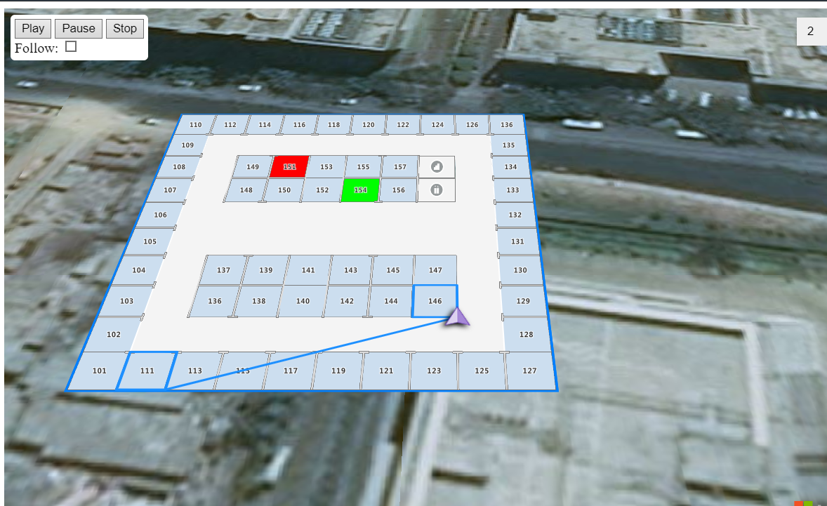
If you see the path(from 146 unit to 101 unit) shown as "straight line overlaps other units". Actually, line should not come like this(it should not overlap)
It's overlapping because of hard coded co-ordinate's . _So, if these list of co-ordinates comes from some API to draw a path, the line /path will get draw properly and it wont be a straight line._
I request someone look into this .
Thanks.
 DivyaVaniChinta
on 29 Jul 2020
DivyaVaniChinta
on 29 Jul 2020
Another customer is also looking into similar query on SO: Azure maps indoor module : How to draw a path between two points in indoor navigation using azure maps?
Hi @SatishBoddu-MSFT its me only :-)
DivyaVaniChinta
on 29 Jul 2020
I am looking into this. Will come back with my findings.
anastasia-ms
on 29 Jul 2020
Just to be clear. The coordinates that @SatishBoddu-MSFT referred to are the coordinates of a polygon in accordance with GeoJSON format, which uses the standard for GPS system . So yes, they are lat/lon coordinates. I am just trying to chase down a sample that I know is around.
anastasia-ms
on 29 Jul 2020
I spoke with the product manager on this, and apparently the info and solution to what you are trying to do is not yet ready to be released at this stage.
anastasia-ms
on 30 Jul 2020
@anastasia-ms , if it is not ready, Would it mean that it is being worked on or at least on the roadmap right? It will be very helpful if you guys can direct us towards a pre-release or a beta version of it, if already available.
Druffl3
on 30 Jul 2020
Yes. It is being worked on. I will update you as soon as I know anything.
anastasia-ms
on 30 Jul 2020
@Druffl3 , @DivyaVaniChinta
We have confirmation from the Product Team that Indoor routing is not yet supported, but it is planned in the future.
So please stay tuned on Azure Maps Indoor Documentation or Subscribe to Azure updates for all quick updates related to Azure Maps.
Thanks for your contribution!
SatishBoddu-MSFT
on 5 Aug 2020
Looking forward to it.
Druffl3
on 7 Aug 2020
Hello @Druffl3 Thanks for your contribution!
We will now proceed to close this thread. If there are further questions regarding this matter, please tag me in your reply. We will gladly continue the discussion and we will reopen the issue.
SatishBoddu-MSFT
on 7 Aug 2020
Related issues
 spottedmahn
·
3Comments
spottedmahn
·
3Comments
 varma31
·
3Comments
varma31
·
3Comments
 bdcoder2
·
3Comments
bdcoder2
·
3Comments
 AronT-TLV
·
3Comments
AronT-TLV
·
3Comments
 behnam89
·
3Comments
behnam89
·
3Comments
Most helpful comment
Yes. It is being worked on. I will update you as soon as I know anything.